Saint-Gaultier
Saint-Gaultier is a commune in the Indre department in central France.
Saint-Gaultier | |
|---|---|
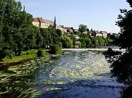 The houses on the banks of the Creuse river | |
 Coat of arms | |
Location of Saint-Gaultier 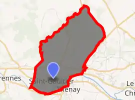
| |
 Saint-Gaultier  Saint-Gaultier | |
| Coordinates: 46°38′10″N 1°25′16″E | |
| Country | France |
| Region | Centre-Val de Loire |
| Department | Indre |
| Arrondissement | Le Blanc |
| Canton | Saint-Gaultier |
| Intercommunality | Pays d'Argenton-sur-Creuse |
| Government | |
| • Mayor (2008–2014) | Jean-Louis Simoulin |
| Area 1 | 9.20 km2 (3.55 sq mi) |
| Population (2017-01-01)[1] | 1,833 |
| • Density | 200/km2 (520/sq mi) |
| Time zone | UTC+01:00 (CET) |
| • Summer (DST) | UTC+02:00 (CEST) |
| INSEE/Postal code | 36192 /36800 |
| Elevation | 91–169 m (299–554 ft) (avg. 113 m or 371 ft) |
| 1 French Land Register data, which excludes lakes, ponds, glaciers > 1 km2 (0.386 sq mi or 247 acres) and river estuaries. | |
Geography
The commune is located in the parc naturel régional de la Brenne.
Population
| Year | Pop. | ±% |
|---|---|---|
| 1793 | 1,131 | — |
| 1800 | 993 | −12.2% |
| 1806 | 1,102 | +11.0% |
| 1821 | 1,334 | +21.1% |
| 1831 | 1,622 | +21.6% |
| 1836 | 1,605 | −1.0% |
| 1841 | 1,793 | +11.7% |
| 1846 | 1,973 | +10.0% |
| 1851 | 2,034 | +3.1% |
| 1856 | 2,013 | −1.0% |
| 1861 | 1,912 | −5.0% |
| 1866 | 1,983 | +3.7% |
| 1872 | 2,122 | +7.0% |
| 1876 | 2,228 | +5.0% |
| 1881 | 2,266 | +1.7% |
| 1886 | 2,539 | +12.0% |
| 1891 | 2,451 | −3.5% |
| 1896 | 2,422 | −1.2% |
| 1901 | 2,430 | +0.3% |
| 1906 | 2,503 | +3.0% |
| 1911 | 2,659 | +6.2% |
| 1921 | 2,382 | −10.4% |
| 1926 | 2,458 | +3.2% |
| 1931 | 2,252 | −8.4% |
| 1936 | 2,217 | −1.6% |
| 1946 | 2,242 | +1.1% |
| 1954 | 2,339 | +4.3% |
| 1962 | 2,133 | −8.8% |
| 1968 | 2,235 | +4.8% |
| 1975 | 2,174 | −2.7% |
| 1982 | 2,042 | −6.1% |
| 1990 | 1,995 | −2.3% |
| 1999 | 1,934 | −3.1% |
| 2006 | 1,958 | +1.2% |
| 2009 | 1,923 | −1.8% |
See also
References
- "Populations légales 2017". INSEE. Retrieved 6 January 2020.
| Wikimedia Commons has media related to Saint-Gaultier. |
| Authority control |
|
|---|
This article is issued from Wikipedia. The text is licensed under Creative Commons - Attribution - Sharealike. Additional terms may apply for the media files.