Gargilesse-Dampierre
Gargilesse-Dampierre is a commune in the Indre department in central France.
Gargilesse-Dampierre | |
|---|---|
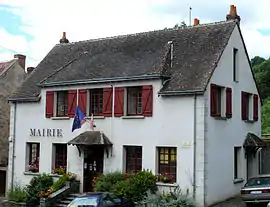 The town hall in Gargilesse | |
Location of Gargilesse-Dampierre 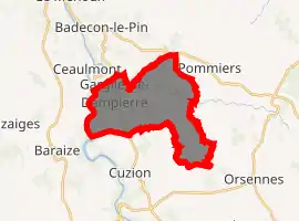
| |
 Gargilesse-Dampierre  Gargilesse-Dampierre | |
| Coordinates: 46°30′52″N 1°35′52″E | |
| Country | France |
| Region | Centre-Val de Loire |
| Department | Indre |
| Arrondissement | Châteauroux |
| Canton | Argenton-sur-Creuse |
| Government | |
| • Mayor (2008–2014) | Vanik Berberian |
| Area 1 | 15.72 km2 (6.07 sq mi) |
| Population (2017-01-01)[1] | 285 |
| • Density | 18/km2 (47/sq mi) |
| Time zone | UTC+01:00 (CET) |
| • Summer (DST) | UTC+02:00 (CEST) |
| INSEE/Postal code | 36081 /36190 |
| Elevation | 124–275 m (407–902 ft) (avg. 221 m or 725 ft) |
| 1 French Land Register data, which excludes lakes, ponds, glaciers > 1 km2 (0.386 sq mi or 247 acres) and river estuaries. | |
It is classified as one of "The most beautiful villages of France" and is situated near the confluence of the Gargilesse stream and the river Creuse. The 19th century writer George Sand lived in the village.
Population
|
|
See also
References
- "Populations légales 2017". INSEE. Retrieved 6 January 2020.
| Wikimedia Commons has media related to Gargilesse-Dampierre. |
| Authority control |
|---|
This article is issued from Wikipedia. The text is licensed under Creative Commons - Attribution - Sharealike. Additional terms may apply for the media files.