Chassignolles, Indre
Chassignolles is a commune in the Indre department in central France.
Chassignolles | |
|---|---|
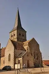 The Church of Saint-Étienne, in Chassignolles | |
Location of Chassignolles 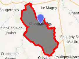
| |
 Chassignolles  Chassignolles | |
| Coordinates: 46°32′28″N 1°56′26″E | |
| Country | France |
| Region | Centre-Val de Loire |
| Department | Indre |
| Arrondissement | La Châtre |
| Canton | Neuvy-Saint-Sépulchre |
| Intercommunality | La Châtre et Sainte-Sévère |
| Government | |
| • Mayor (2008–2014) | Élisabeth Labesse |
| Area 1 | 29.94 km2 (11.56 sq mi) |
| Population (2017-01-01)[1] | 568 |
| • Density | 19/km2 (49/sq mi) |
| Time zone | UTC+01:00 (CET) |
| • Summer (DST) | UTC+02:00 (CEST) |
| INSEE/Postal code | 36043 /36400 |
| Elevation | 204–376 m (669–1,234 ft) (avg. 283 m or 928 ft) |
| 1 French Land Register data, which excludes lakes, ponds, glaciers > 1 km2 (0.386 sq mi or 247 acres) and river estuaries. | |
Population
| Year | Pop. | ±% |
|---|---|---|
| 1793 | 788 | — |
| 1800 | 763 | −3.2% |
| 1806 | 652 | −14.5% |
| 1821 | 910 | +39.6% |
| 1831 | 967 | +6.3% |
| 1836 | 980 | +1.3% |
| 1841 | 968 | −1.2% |
| 1846 | 995 | +2.8% |
| 1851 | 1,040 | +4.5% |
| 1856 | 1,050 | +1.0% |
| 1861 | 1,036 | −1.3% |
| 1866 | 1,023 | −1.3% |
| 1872 | 1,055 | +3.1% |
| 1876 | 1,145 | +8.5% |
| 1881 | 1,181 | +3.1% |
| 1886 | 1,201 | +1.7% |
| 1891 | 1,249 | +4.0% |
| 1896 | 1,303 | +4.3% |
| 1901 | 1,261 | −3.2% |
| 1906 | 1,278 | +1.3% |
| 1911 | 1,326 | +3.8% |
| 1921 | 1,191 | −10.2% |
| 1926 | 1,220 | +2.4% |
| 1931 | 1,196 | −2.0% |
| 1936 | 1,146 | −4.2% |
| 1946 | 1,104 | −3.7% |
| 1954 | 963 | −12.8% |
| 1962 | 898 | −6.7% |
| 1968 | 826 | −8.0% |
| 1975 | 680 | −17.7% |
| 1982 | 567 | −16.6% |
| 1990 | 548 | −3.4% |
| 1999 | 543 | −0.9% |
| 2009 | 583 | +7.4% |
See also
References
- "Populations légales 2017". INSEE. Retrieved 6 January 2020.
| Wikimedia Commons has media related to Chassignolles (Indre). |
| Authority control |
|
|---|
This article is issued from Wikipedia. The text is licensed under Creative Commons - Attribution - Sharealike. Additional terms may apply for the media files.