Le Blanc
Le Blanc (French pronunciation: [lə blɑ̃]) is a commune and a sub-prefecture of the Indre department in central France.
Le Blanc | |
|---|---|
Subprefecture and commune | |
 Château de Naillac | |
.svg.png.webp) Coat of arms | |
Location of Le Blanc 
| |
 Le Blanc  Le Blanc | |
| Coordinates: 46°38′04″N 1°03′49″E | |
| Country | France |
| Region | Centre-Val de Loire |
| Department | Indre |
| Arrondissement | Le Blanc |
| Canton | Le Blanc |
| Government | |
| • Mayor (2008–2014) | Jean-Paul Chanteguet |
| Area 1 | 57.61 km2 (22.24 sq mi) |
| Population (2017-01-01)[1] | 6,389 |
| • Density | 110/km2 (290/sq mi) |
| Time zone | UTC+01:00 (CET) |
| • Summer (DST) | UTC+02:00 (CEST) |
| INSEE/Postal code | 36018 /36300 |
| Elevation | 72–140 m (236–459 ft) (avg. 120 m or 390 ft) |
| 1 French Land Register data, which excludes lakes, ponds, glaciers > 1 km2 (0.386 sq mi or 247 acres) and river estuaries. | |
Geography
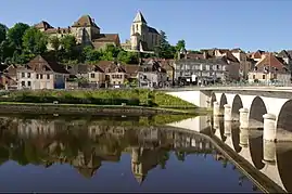
Le Blanc is the main city of the Parc naturel régional de la Brenne, on the banks of the Creuse River.
Population
| Year | Pop. | ±% |
|---|---|---|
| 1793 | 4,780 | — |
| 1800 | 4,723 | −1.2% |
| 1806 | 3,662 | −22.5% |
| 1821 | 4,452 | +21.6% |
| 1831 | 4,804 | +7.9% |
| 1836 | 5,095 | +6.1% |
| 1841 | 5,290 | +3.8% |
| 1846 | 6,075 | +14.8% |
| 1851 | 6,788 | +11.7% |
| 1856 | 5,731 | −15.6% |
| 1861 | 5,882 | +2.6% |
| 1866 | 5,956 | +1.3% |
| 1872 | 5,709 | −4.1% |
| 1876 | 6,122 | +7.2% |
| 1881 | 6,558 | +7.1% |
| 1886 | 7,140 | +8.9% |
| 1891 | 7,389 | +3.5% |
| 1896 | 6,764 | −8.5% |
| 1901 | 6,663 | −1.5% |
| 1906 | 6,520 | −2.1% |
| 1911 | 6,493 | −0.4% |
| 1921 | 5,284 | −18.6% |
| 1926 | 5,511 | +4.3% |
| 1931 | 5,426 | −1.5% |
| 1936 | 5,789 | +6.7% |
| 1946 | 6,719 | +16.1% |
| 1954 | 6,427 | −4.3% |
| 1962 | 6,402 | −0.4% |
| 1968 | 6,767 | +5.7% |
| 1975 | 8,024 | +18.6% |
| 1982 | 7,769 | −3.2% |
| 1990 | 7,361 | −5.3% |
| 1999 | 6,995 | −5.0% |
| 2009 | 6,946 | −0.7% |
Facilities
Near Le Blanc, there is a VLF-transmitter of French Navy. It transmits messages on 18.3 kHz and 21.7 kHz to submerged submarines [2]
See also
- Saint-Benoît-du-Sault
- Communes of the Indre department
- Marcel Gaumont. Sculptor of war memorial
References
- "Populations légales 2017". INSEE. Retrieved 6 January 2020.
- RDF_project Archived 2007-09-22 at the Wayback Machine
External links
| Wikimedia Commons has media related to Le Blanc (Indre). |
- . Encyclopædia Britannica. 16 (11th ed.). 1911. p. 351.
| Authority control |
|---|
This article is issued from Wikipedia. The text is licensed under Creative Commons - Attribution - Sharealike. Additional terms may apply for the media files.