Brunet, Alpes-de-Haute-Provence
Brunet is a commune in the Alpes-de-Haute-Provence department in southeastern France.
Brunet | |
|---|---|
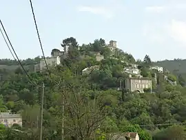 The village of Brunet, seen from the north | |
 Coat of arms | |
Location of Brunet 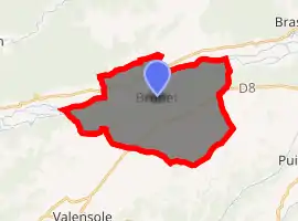
| |
 Brunet  Brunet | |
| Coordinates: 43°53′32″N 6°01′52″E | |
| Country | France |
| Region | Provence-Alpes-Côte d'Azur |
| Department | Alpes-de-Haute-Provence |
| Arrondissement | Forcalquier |
| Canton | Valensole |
| Government | |
| • Mayor (2008–2014) | Francis Berard |
| Area 1 | 28.47 km2 (10.99 sq mi) |
| Population (2017-01-01)[1] | 278 |
| • Density | 9.8/km2 (25/sq mi) |
| Time zone | UTC+01:00 (CET) |
| • Summer (DST) | UTC+02:00 (CEST) |
| INSEE/Postal code | 04035 /04210 |
| Elevation | 369–690 m (1,211–2,264 ft) (avg. 425 m or 1,394 ft) |
| 1 French Land Register data, which excludes lakes, ponds, glaciers > 1 km2 (0.386 sq mi or 247 acres) and river estuaries. | |
Geography
The village lies on the left bank of the Asse, which forms most of the commune's northern border.
Population
|
|
References
- "Populations légales 2017". INSEE. Retrieved 6 January 2020.
| Wikimedia Commons has media related to Brunet, Alpes-de-Haute-Provence. |
This article is issued from Wikipedia. The text is licensed under Creative Commons - Attribution - Sharealike. Additional terms may apply for the media files.