Uvernet-Fours
Uvernet-Fours is a commune in the Alpes-de-Haute-Provence department in southeastern France.
Uvernet-Fours | |
|---|---|
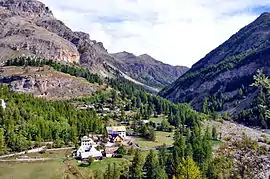 The hamlet of Bayasse in the La Moutière valley | |
 Coat of arms | |
Location of Uvernet-Fours 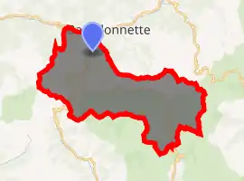
| |
 Uvernet-Fours  Uvernet-Fours | |
| Coordinates: 44°21′43″N 6°37′37″E | |
| Country | France |
| Region | Provence-Alpes-Côte d'Azur |
| Department | Alpes-de-Haute-Provence |
| Arrondissement | Barcelonnette |
| Canton | Barcelonnette |
| Intercommunality | Vallée de l'Ubaye |
| Government | |
| • Mayor (2008–2014) | Bruno Vaginay |
| Area 1 | 135.44 km2 (52.29 sq mi) |
| Population | 586 |
| • Density | 4.3/km2 (11/sq mi) |
| Time zone | UTC+01:00 (CET) |
| • Summer (DST) | UTC+02:00 (CEST) |
| INSEE/Postal code | 04226 /04400 |
| Elevation | 1,093–3,040 m (3,586–9,974 ft) (avg. 1,180 m or 3,870 ft) |
| 1 French Land Register data, which excludes lakes, ponds, glaciers > 1 km2 (0.386 sq mi or 247 acres) and river estuaries. | |
Population
| Year | Pop. | ±% |
|---|---|---|
| 1793 | 769 | — |
| 1800 | 835 | +8.6% |
| 1806 | 804 | −3.7% |
| 1821 | 815 | +1.4% |
| 1831 | 806 | −1.1% |
| 1836 | 846 | +5.0% |
| 1841 | 856 | +1.2% |
| 1846 | 767 | −10.4% |
| 1851 | 734 | −4.3% |
| 1856 | 676 | −7.9% |
| 1861 | 624 | −7.7% |
| 1866 | 613 | −1.8% |
| 1872 | 580 | −5.4% |
| 1876 | 541 | −6.7% |
| 1881 | 543 | +0.4% |
| 1886 | 544 | +0.2% |
| 1891 | 443 | −18.6% |
| 1896 | 406 | −8.4% |
| 1901 | 461 | +13.5% |
| 1906 | 418 | −9.3% |
| 1911 | 354 | −15.3% |
| 1921 | 279 | −21.2% |
| 1926 | 256 | −8.2% |
| 1931 | 228 | −10.9% |
| 1936 | 207 | −9.2% |
| 1946 | 177 | −14.5% |
| 1954 | 140 | −20.9% |
| 1962 | 114 | −18.6% |
| 1968 | 253 | +121.9% |
| 1975 | 506 | +100.0% |
| 1982 | 526 | +4.0% |
| 1990 | 543 | +3.2% |
| 1999 | 614 | +13.1% |
| 2008 | 637 | +3.7% |
References
- "Populations légales 2017". INSEE. Retrieved 6 January 2020.
| Wikimedia Commons has media related to Uvernet-Fours. |
| Authority control |
|---|
This article is issued from Wikipedia. The text is licensed under Creative Commons - Attribution - Sharealike. Additional terms may apply for the media files.