La Garde, Alpes-de-Haute-Provence
La Garde is a commune in the Alpes-de-Haute-Provence department in southeastern France.
La Garde | |
|---|---|
%252C_le_village_et_le_Rocher_Saint-Martin.jpg.webp) The village of La Garde overlooked by La Rocher Saint-Martin | |
 Coat of arms | |
Location of La Garde 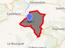
| |
 La Garde  La Garde | |
| Coordinates: 43°49′51″N 6°33′29″E | |
| Country | France |
| Region | Provence-Alpes-Côte d'Azur |
| Department | Alpes-de-Haute-Provence |
| Arrondissement | Castellane |
| Canton | Castellane |
| Government | |
| • Mayor (2008–2014) | Henri Belisaire |
| Area 1 | 16.63 km2 (6.42 sq mi) |
| Population (2017-01-01)[1] | 89 |
| • Density | 5.4/km2 (14/sq mi) |
| Time zone | UTC+01:00 (CET) |
| • Summer (DST) | UTC+02:00 (CEST) |
| INSEE/Postal code | 04092 /04120 |
| Elevation | 777–1,894 m (2,549–6,214 ft) (avg. 900 m or 3,000 ft) |
| 1 French Land Register data, which excludes lakes, ponds, glaciers > 1 km2 (0.386 sq mi or 247 acres) and river estuaries. | |
Population
|
|
References
- "Populations légales 2017". INSEE. Retrieved 6 January 2020.
| Wikimedia Commons has media related to La Garde, Alpes-de-Haute-Provence. |
| Authority control |
|
|---|
This article is issued from Wikipedia. The text is licensed under Creative Commons - Attribution - Sharealike. Additional terms may apply for the media files.