La Condamine-Châtelard
La Condamine-Châtelard is a commune in the Alpes-de-Haute-Provence department in southeastern France.
La Condamine-Châtelard | |
|---|---|
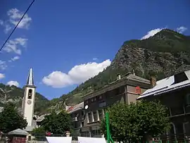 The church, school and surrounding buildings in La Condamine-Châtelard | |
Location of La Condamine-Châtelard 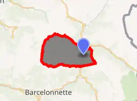
| |
 La Condamine-Châtelard  La Condamine-Châtelard | |
| Coordinates: 44°27′32″N 6°44′47″E | |
| Country | France |
| Region | Provence-Alpes-Côte d'Azur |
| Department | Alpes-de-Haute-Provence |
| Arrondissement | Barcelonnette |
| Canton | Barcelonnette |
| Government | |
| • Mayor (2008–2014) | François Honoré |
| Area 1 | 56.08 km2 (21.65 sq mi) |
| Population (2017-01-01)[1] | 155 |
| • Density | 2.8/km2 (7.2/sq mi) |
| Time zone | UTC+01:00 (CET) |
| • Summer (DST) | UTC+02:00 (CEST) |
| INSEE/Postal code | 04062 /04530 |
| Elevation | 1,239–3,047 m (4,065–9,997 ft) (avg. 1,305 m or 4,281 ft) |
| 1 French Land Register data, which excludes lakes, ponds, glaciers > 1 km2 (0.386 sq mi or 247 acres) and river estuaries. | |
Population
|
|
References
- "Populations légales 2017". INSEE. Retrieved 6 January 2020.
| Wikimedia Commons has media related to La Condamine-Châtelard. |
This article is issued from Wikipedia. The text is licensed under Creative Commons - Attribution - Sharealike. Additional terms may apply for the media files.