Montfuron
Montfuron is a commune in the Alpes-de-Haute-Provence department in southeastern France.
Montfuron | |
|---|---|
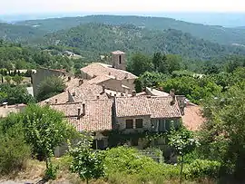 The church and surrounding buildings in Montfuron | |
 Coat of arms | |
Location of Montfuron 
| |
 Montfuron  Montfuron | |
| Coordinates: 43°50′12″N 5°41′41″E | |
| Country | France |
| Region | Provence-Alpes-Côte d'Azur |
| Department | Alpes-de-Haute-Provence |
| Arrondissement | Forcalquier |
| Canton | Manosque-1 |
| Government | |
| • Mayor (2008–2014) | Pierre Fischer |
| Area 1 | 18.88 km2 (7.29 sq mi) |
| Population (2017-01-01)[1] | 210 |
| • Density | 11/km2 (29/sq mi) |
| Time zone | UTC+01:00 (CET) |
| • Summer (DST) | UTC+02:00 (CEST) |
| INSEE/Postal code | 04128 /04110 |
| Elevation | 373–706 m (1,224–2,316 ft) (avg. 650 m or 2,130 ft) |
| 1 French Land Register data, which excludes lakes, ponds, glaciers > 1 km2 (0.386 sq mi or 247 acres) and river estuaries. | |
Population
|
|
References
- "Populations légales 2017". INSEE. Retrieved 6 January 2020.
| Wikimedia Commons has media related to Montfuron. |
This article is issued from Wikipedia. The text is licensed under Creative Commons - Attribution - Sharealike. Additional terms may apply for the media files.
