Blieux
Blieux is a commune in the Alpes-de-Haute-Provence department in southeastern France.
Blieux | |
|---|---|
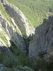 A ravine in the territory of the Blieux commune | |
 Coat of arms | |
Location of Blieux 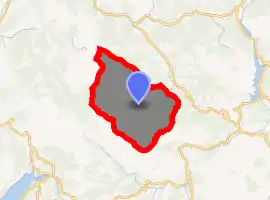
| |
 Blieux  Blieux | |
| Coordinates: 43°52′24″N 6°22′18″E | |
| Country | France |
| Region | Provence-Alpes-Côte d'Azur |
| Department | Alpes-de-Haute-Provence |
| Arrondissement | Castellane |
| Canton | Riez |
| Government | |
| • Mayor (2008–2014) | Marcel Collomp |
| Area 1 | 56.8 km2 (21.9 sq mi) |
| Population (2017-01-01)[1] | 60 |
| • Density | 1.1/km2 (2.7/sq mi) |
| Time zone | UTC+01:00 (CET) |
| • Summer (DST) | UTC+02:00 (CEST) |
| INSEE/Postal code | 04030 /04330 |
| Elevation | 831–1,921 m (2,726–6,302 ft) (avg. 950 m or 3,120 ft) |
| 1 French Land Register data, which excludes lakes, ponds, glaciers > 1 km2 (0.386 sq mi or 247 acres) and river estuaries. | |
History
The commune of Blieux first appeared on maps in 1100.[2]
Much later, during the French Revolution, records show that the residents of Blieux had created a political club (patriotic society), which was very common at the time. (See Jacobin Club).[3]
Name of the commune
According to Ernest Nègre, the first recorded name for the commune, Bleus, was derived from the Occitan word bleusse, meaning 'dry'. This was likely a reference to the local soil.[4] By contrast, Charles Rostaing argues that the name derives from the pre-Indo-European root word, *BL, meaning 'mountain in the form of a spur'.[5]
La Melle, the name of a nearby hamlet, comes from the Celtic word, mello, meaning an elevated location.[6]
Economy
Historically, Blieux was a pastoral community, with a yearly alpine grazing cycle known as transhumance. As with much of Provence, tourism the primary source of economic activity today.
Geography
The village is located at an altitude of 950m,[2] in the valley formed by a tributary of the river Asse, known as the 'Asse de Blieux'.
Hamlets
- le Bas-Chadoul
- la Melle
- la Tuilière
- Thon
- La Castelle
Summits and passes
- Mont Chiran (1905 m)
- le Grand Mourre (1898 m)
- Crête de Montmuye (Montmuye ridge) (Highest point: 1621 m)
- Le Mourre de Chanier ( 1930 m)
Population
|
|
With the exception of those that have been totally abandoned, Blieux is one of the communities in the Alpes-de-Haute-Provence department that has experienced the greatest population decline from the mid-19th to the mid-20th centuries.
Inhabitants are known as Blieuxois.
References
- "Populations légales 2017". INSEE. Retrieved 6 January 2020.
- de La Torre, Michel (1989). Deslogis-Lacoste (ed.). Alpes-de-Haute-Provence : le guide complet des 200 communes (in French). Paris. p. 72. ISBN 2-7399-5004-7.
- Patrice Alphand, « Les Sociétés populaires», La Révolution dans les Basses-Alpes, Annales de Haute-Provence, bulletin de la société scientifique et littéraire des Alpes-de-Haute-Provence, no. 307, 1989, pp. 296-298
- Ernest Nègre, Toponymie générale de la France : étymologie de 35 000 noms de lieux, Genève : Librairie Droz, 1990. Volume II : Formations dialectales. Notice 23793, p 1281
- Charles Rostaing, Essai sur la toponymie de la Provence (depuis les origines jusqu’aux invasions barbares), Laffite Reprints, Marseille, 1973, p. 85
- Rostaing, p. 206
| Wikimedia Commons has media related to Blieux. |