Mane, Alpes-de-Haute-Provence
Mane (Mana in Occitan) is a commune in Alpes-de-Haute-Provence department in southeastern France.
Mane | |
|---|---|
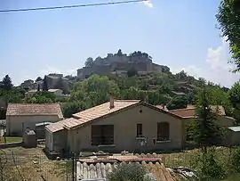 A general view of the village of Mane | |
 Coat of arms | |
Location of Mane 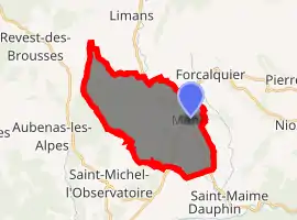
| |
 Mane  Mane | |
| Coordinates: 43°56′21″N 5°46′06″E | |
| Country | France |
| Region | Provence-Alpes-Côte d'Azur |
| Department | Alpes-de-Haute-Provence |
| Arrondissement | Forcalquier |
| Canton | Reillanne |
| Intercommunality | Haute Provence |
| Government | |
| • Mayor (2008–2014) | Jacques Depieds |
| Area 1 | 22 km2 (8 sq mi) |
| Population (2017-01-01)[1] | 1,349 |
| • Density | 61/km2 (160/sq mi) |
| Time zone | UTC+01:00 (CET) |
| • Summer (DST) | UTC+02:00 (CEST) |
| INSEE/Postal code | 04111 /04300 |
| Elevation | 386–868 m (1,266–2,848 ft) (avg. 500 m or 1,600 ft) |
| 1 French Land Register data, which excludes lakes, ponds, glaciers > 1 km2 (0.386 sq mi or 247 acres) and river estuaries. | |
It lies near Forcalquier. It was the birthplace of Louis Feuillée and the 18th-century botanist Jean-Paul de Rome d'Ardène. A Minim convent was situated here. The ancient Pont sur Laye is close by the town.
Population
| Year | Pop. | ±% |
|---|---|---|
| 1765 | 1,281 | — |
| 1793 | 1,357 | +5.9% |
| 1800 | 1,324 | −2.4% |
| 1806 | 1,408 | +6.3% |
| 1821 | 1,461 | +3.8% |
| 1831 | 1,542 | +5.5% |
| 1836 | 1,507 | −2.3% |
| 1841 | 1,495 | −0.8% |
| 1846 | 1,583 | +5.9% |
| 1851 | 1,521 | −3.9% |
| 1856 | 1,522 | +0.1% |
| 1861 | 1,528 | +0.4% |
| 1866 | 1,446 | −5.4% |
| 1872 | 1,430 | −1.1% |
| 1876 | 1,335 | −6.6% |
| 1881 | 1,333 | −0.1% |
| 1886 | 1,430 | +7.3% |
| 1891 | 1,174 | −17.9% |
| 1896 | 1,099 | −6.4% |
| 1901 | 1,066 | −3.0% |
| 1906 | 1,012 | −5.1% |
| 1911 | 987 | −2.5% |
| 1921 | 990 | +0.3% |
| 1926 | 830 | −16.2% |
| 1931 | 744 | −10.4% |
| 1936 | 775 | +4.2% |
| 1946 | 690 | −11.0% |
| 1954 | 674 | −2.3% |
| 1962 | 703 | +4.3% |
| 1968 | 852 | +21.2% |
| 1975 | 834 | −2.1% |
| 1982 | 943 | +13.1% |
| 1990 | 1,135 | +20.4% |
| 1999 | 1,169 | +3.0% |
| 2008 | 1,355 | +15.9% |
References
- "Populations légales 2017". INSEE. Retrieved 6 January 2020.
| Wikimedia Commons has media related to Mane, Alpes-de-Haute-Provence. |
| Authority control |
|---|
This article is issued from Wikipedia. The text is licensed under Creative Commons - Attribution - Sharealike. Additional terms may apply for the media files.