Le Castellard-Mélan
Le Castellard-Mélan (before 2010: Le Castellard-Melan)[2] is a commune in the Alpes-de-Haute-Provence department in southeastern France.
Le Castellard-Mélan | |
|---|---|
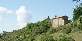 The chapel of Our Lady, with the ruins of the castle in the background | |
 Coat of arms | |
Location of Le Castellard-Mélan 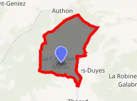
| |
 Le Castellard-Mélan  Le Castellard-Mélan | |
| Coordinates: 44°11′18″N 6°07′32″E | |
| Country | France |
| Region | Provence-Alpes-Côte d'Azur |
| Department | Alpes-de-Haute-Provence |
| Arrondissement | Digne-les-Bains |
| Canton | Digne-les-Bains-1 |
| Intercommunality | Duyes et Bléone |
| Government | |
| • Mayor (2008–2014) | Jacques Julien |
| Area 1 | 25.74 km2 (9.94 sq mi) |
| Population (2017-01-01)[1] | 64 |
| • Density | 2.5/km2 (6.4/sq mi) |
| Time zone | UTC+01:00 (CET) |
| • Summer (DST) | UTC+02:00 (CEST) |
| INSEE/Postal code | 04040 /04380 |
| Elevation | 776–1,840 m (2,546–6,037 ft) (avg. 1,050 m or 3,440 ft) |
| 1 French Land Register data, which excludes lakes, ponds, glaciers > 1 km2 (0.386 sq mi or 247 acres) and river estuaries. | |
Population
| Year | Pop. | ±% |
|---|---|---|
| 1765 | 172 | — |
| 1793 | 197 | +14.5% |
| 1806 | 199 | +1.0% |
| 1821 | 175 | −12.1% |
| 1831 | 175 | +0.0% |
| 1836 | 195 | +11.4% |
| 1841 | 207 | +6.2% |
| 1846 | 177 | −14.5% |
| 1851 | 167 | −5.6% |
| 1856 | 186 | +11.4% |
| 1861 | 174 | −6.5% |
| 1866 | 176 | +1.1% |
| 1872 | 165 | −6.2% |
| 1876 | 160 | −3.0% |
| 1881 | 171 | +6.9% |
| 1886 | 174 | +1.8% |
| 1891 | 147 | −15.5% |
| 1896 | 120 | −18.4% |
| 1901 | 132 | +10.0% |
| 1906 | 118 | −10.6% |
| 1911 | 110 | −6.8% |
| 1921 | 88 | −20.0% |
| 1926 | 86 | −2.3% |
| 1931 | 82 | −4.7% |
| 1936 | 70 | −14.6% |
| 1946 | 61 | −12.9% |
| 1954 | 64 | +4.9% |
| 1962 | 58 | −9.4% |
| 1968 | 47 | −19.0% |
| 1975 | 47 | +0.0% |
| 1982 | 55 | +17.0% |
| 1990 | 52 | −5.5% |
| 1999 | 52 | +0.0% |
| 2008 | 55 | +5.8% |
References
- "Populations légales 2017". INSEE. Retrieved 6 January 2020.
- INSEE
| Wikimedia Commons has media related to Le Castellard-Mélan. |
| Authority control |
|
|---|
This article is issued from Wikipedia. The text is licensed under Creative Commons - Attribution - Sharealike. Additional terms may apply for the media files.