Mallemoisson
Mallemoisson is a commune in the Alpes-de-Haute-Provence department in southeastern France.
Mallemoisson | |
|---|---|
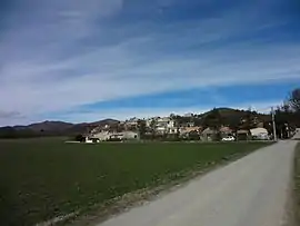 A general view of the village of Mallemoisson | |
 Coat of arms | |
Location of Mallemoisson 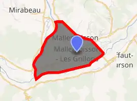
| |
 Mallemoisson  Mallemoisson | |
| Coordinates: 44°02′34″N 6°07′33″E | |
| Country | France |
| Region | Provence-Alpes-Côte d'Azur |
| Department | Alpes-de-Haute-Provence |
| Arrondissement | Digne-les-Bains |
| Canton | Digne-les-Bains-2 |
| Intercommunality | Duyes et Bléone |
| Government | |
| • Mayor (2008–2014) | André Nalin |
| Area 1 | 6.04 km2 (2.33 sq mi) |
| Population (2017-01-01)[1] | 1,046 |
| • Density | 170/km2 (450/sq mi) |
| Time zone | UTC+01:00 (CET) |
| • Summer (DST) | UTC+02:00 (CEST) |
| INSEE/Postal code | 04110 /04510 |
| Elevation | 476–663 m (1,562–2,175 ft) (avg. 505 m or 1,657 ft) |
| 1 French Land Register data, which excludes lakes, ponds, glaciers > 1 km2 (0.386 sq mi or 247 acres) and river estuaries. | |
Geography
The Bléone forms the commune's southern border.
Population
| Year | Pop. | ±% |
|---|---|---|
| 1765 | 233 | — |
| 1793 | 236 | +1.3% |
| 1806 | 238 | +0.8% |
| 1821 | 227 | −4.6% |
| 1831 | 250 | +10.1% |
| 1836 | 275 | +10.0% |
| 1841 | 279 | +1.5% |
| 1846 | 295 | +5.7% |
| 1851 | 289 | −2.0% |
| 1856 | 285 | −1.4% |
| 1861 | 286 | +0.4% |
| 1866 | 283 | −1.0% |
| 1872 | 285 | +0.7% |
| 1876 | 321 | +12.6% |
| 1881 | 326 | +1.6% |
| 1886 | 326 | +0.0% |
| 1891 | 288 | −11.7% |
| 1896 | 289 | +0.3% |
| 1901 | 301 | +4.2% |
| 1906 | 303 | +0.7% |
| 1911 | 258 | −14.9% |
| 1921 | 233 | −9.7% |
| 1926 | 249 | +6.9% |
| 1931 | 251 | +0.8% |
| 1936 | 230 | −8.4% |
| 1946 | 233 | +1.3% |
| 1954 | 234 | +0.4% |
| 1962 | 325 | +38.9% |
| 1968 | 355 | +9.2% |
| 1975 | 415 | +16.9% |
| 1982 | 612 | +47.5% |
| 1990 | 783 | +27.9% |
| 1999 | 994 | +26.9% |
| 2008 | 1,032 | +3.8% |
References
- "Populations légales 2017". INSEE. Retrieved 6 January 2020.
| Wikimedia Commons has media related to Mallemoisson. |
| Authority control |
|
|---|
This article is issued from Wikipedia. The text is licensed under Creative Commons - Attribution - Sharealike. Additional terms may apply for the media files.