Le Chaffaut-Saint-Jurson
Le Chaffaut-St-Jurson is a commune in the Alpes-de-Haute-Provence department in southeastern France.
Le Chaffaut-Saint-Jurson | |
|---|---|
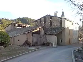 A barn in the village of Le Chaffaut-Saint-Jurson | |
 Coat of arms | |
Location of Le Chaffaut-Saint-Jurson 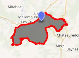
| |
 Le Chaffaut-Saint-Jurson  Le Chaffaut-Saint-Jurson | |
| Coordinates: 44°02′20″N 6°09′03″E | |
| Country | France |
| Region | Provence-Alpes-Côte d'Azur |
| Department | Alpes-de-Haute-Provence |
| Arrondissement | Digne-les-Bains |
| Canton | Riez |
| Intercommunality | Duyes et Bléone |
| Government | |
| • Mayor (2008–2014) | Jean-Pierre Feraud |
| Area 1 | 36.2 km2 (14.0 sq mi) |
| Population | 689 |
| • Density | 19/km2 (49/sq mi) |
| Time zone | UTC+01:00 (CET) |
| • Summer (DST) | UTC+02:00 (CEST) |
| INSEE/Postal code | 04046 /04510 |
| Elevation | 470–960 m (1,540–3,150 ft) (avg. 584 m or 1,916 ft) |
| 1 French Land Register data, which excludes lakes, ponds, glaciers > 1 km2 (0.386 sq mi or 247 acres) and river estuaries. | |
Geography
The Bléone forms the commune's northwestern border.
Population
| Year | Pop. | ±% |
|---|---|---|
| 1765 | 208 | — |
| 1793 | 216 | +3.8% |
| 1800 | 215 | −0.5% |
| 1806 | 246 | +14.4% |
| 1821 | 244 | −0.8% |
| 1831 | 231 | −5.3% |
| 1836 | 256 | +10.8% |
| 1841 | 262 | +2.3% |
| 1846 | 275 | +5.0% |
| 1851 | 274 | −0.4% |
| 1856 | 295 | +7.7% |
| 1861 | 295 | +0.0% |
| 1866 | 288 | −2.4% |
| 1872 | 234 | −18.8% |
| 1876 | 242 | +3.4% |
| 1881 | 300 | +24.0% |
| 1886 | 336 | +12.0% |
| 1891 | 296 | −11.9% |
| 1896 | 247 | −16.6% |
| 1901 | 265 | +7.3% |
| 1906 | 224 | −15.5% |
| 1911 | 230 | +2.7% |
| 1921 | 210 | −8.7% |
| 1926 | 206 | −1.9% |
| 1931 | 212 | +2.9% |
| 1936 | 184 | −13.2% |
| 1946 | 166 | −9.8% |
| 1954 | 157 | −5.4% |
| 1962 | 168 | +7.0% |
| 1968 | 178 | +6.0% |
| 1975 | 229 | +28.7% |
| 1982 | 346 | +51.1% |
| 1990 | 510 | +47.4% |
| 1999 | 674 | +32.2% |
| 2008 | 721 | +7.0% |
References
- "Populations légales 2017". INSEE. Retrieved 6 January 2020.
| Wikimedia Commons has media related to Le Chaffaut-Saint-Jurson. |
This article is issued from Wikipedia. The text is licensed under Creative Commons - Attribution - Sharealike. Additional terms may apply for the media files.
