Pierrevert
Pierrevert is a commune in the Alpes-de-Haute-Provence department in southeastern France.
Pierrevert | |
|---|---|
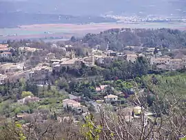 A general view of the village of Pierrevert | |
 Coat of arms | |
Location of Pierrevert 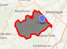
| |
 Pierrevert  Pierrevert | |
| Coordinates: 43°48′44″N 5°45′01″E | |
| Country | France |
| Region | Provence-Alpes-Côte d'Azur |
| Department | Alpes-de-Haute-Provence |
| Arrondissement | Forcalquier |
| Canton | Manosque-1 |
| Intercommunality | Sud 4 |
| Government | |
| • Mayor (2008–2014) | Sylviane Chaumont-Gorius |
| Area 1 | 27.9 km2 (10.8 sq mi) |
| Population (2017-01-01)[1] | 3,816 |
| • Density | 140/km2 (350/sq mi) |
| Time zone | UTC+01:00 (CET) |
| • Summer (DST) | UTC+02:00 (CEST) |
| INSEE/Postal code | 04152 /04860 |
| Elevation | 308–618 m (1,010–2,028 ft) (avg. 442 m or 1,450 ft) |
| 1 French Land Register data, which excludes lakes, ponds, glaciers > 1 km2 (0.386 sq mi or 247 acres) and river estuaries. | |
Population
| Year | Pop. | ±% |
|---|---|---|
| 1765 | 723 | — |
| 1793 | 768 | +6.2% |
| 1800 | 755 | −1.7% |
| 1806 | 886 | +17.4% |
| 1821 | 908 | +2.5% |
| 1831 | 852 | −6.2% |
| 1836 | 821 | −3.6% |
| 1841 | 902 | +9.9% |
| 1846 | 871 | −3.4% |
| 1851 | 850 | −2.4% |
| 1856 | 803 | −5.5% |
| 1861 | 813 | +1.2% |
| 1866 | 785 | −3.4% |
| 1872 | 730 | −7.0% |
| 1876 | 702 | −3.8% |
| 1881 | 662 | −5.7% |
| 1886 | 616 | −6.9% |
| 1891 | 526 | −14.6% |
| 1896 | 528 | +0.4% |
| 1901 | 522 | −1.1% |
| 1906 | 525 | +0.6% |
| 1911 | 519 | −1.1% |
| 1921 | 522 | +0.6% |
| 1926 | 403 | −22.8% |
| 1931 | 421 | +4.5% |
| 1936 | 405 | −3.8% |
| 1946 | 347 | −14.3% |
| 1954 | 431 | +24.2% |
| 1962 | 518 | +20.2% |
| 1968 | 1,028 | +98.5% |
| 1975 | 1,772 | +72.4% |
| 1982 | 2,560 | +44.5% |
| 1990 | 2,914 | +13.8% |
| 1999 | 3,280 | +12.6% |
| 2008 | 3,614 | +10.2% |
References
- "Populations légales 2017". INSEE. Retrieved 6 January 2020.
| Wikimedia Commons has media related to Pierrevert. |
| Authority control |
|---|
This article is issued from Wikipedia. The text is licensed under Creative Commons - Attribution - Sharealike. Additional terms may apply for the media files.
