Saint-Lions
Saint-Lions is a commune in the Alpes-de-Haute-Provence department in southeastern France.
Saint-Lions | |
|---|---|
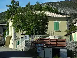 The town hall in Saint-Lions | |
Location of Saint-Lions 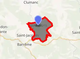
| |
 Saint-Lions  Saint-Lions | |
| Coordinates: 43°59′10″N 6°24′01″E | |
| Country | France |
| Region | Provence-Alpes-Côte d'Azur |
| Department | Alpes-de-Haute-Provence |
| Arrondissement | Castellane |
| Canton | Riez |
| Intercommunality | Moyen Verdon |
| Government | |
| • Mayor (2008–2014) | Madeleine Isnard |
| Area 1 | 11.55 km2 (4.46 sq mi) |
| Population (2017-01-01)[1] | 49 |
| • Density | 4.2/km2 (11/sq mi) |
| Time zone | UTC+01:00 (CET) |
| • Summer (DST) | UTC+02:00 (CEST) |
| INSEE/Postal code | 04187 /04330 |
| Elevation | 739–1,589 m (2,425–5,213 ft) (avg. 800 m or 2,600 ft) |
| 1 French Land Register data, which excludes lakes, ponds, glaciers > 1 km2 (0.386 sq mi or 247 acres) and river estuaries. | |
Geography
The river Asse de Clumanc flows south through the western part of the commune.
Population
| Year | Pop. | ±% |
|---|---|---|
| 1793 | 189 | — |
| 1800 | 197 | +4.2% |
| 1806 | 186 | −5.6% |
| 1821 | 229 | +23.1% |
| 1831 | 181 | −21.0% |
| 1836 | 200 | +10.5% |
| 1841 | 193 | −3.5% |
| 1846 | 192 | −0.5% |
| 1851 | 187 | −2.6% |
| 1856 | 159 | −15.0% |
| 1861 | 163 | +2.5% |
| 1866 | 164 | +0.6% |
| 1872 | 163 | −0.6% |
| 1876 | 137 | −16.0% |
| 1881 | 147 | +7.3% |
| 1886 | 129 | −12.2% |
| 1891 | 123 | −4.7% |
| 1896 | 112 | −8.9% |
| 1901 | 110 | −1.8% |
| 1906 | 86 | −21.8% |
| 1911 | 74 | −14.0% |
| 1921 | 75 | +1.4% |
| 1926 | 58 | −22.7% |
| 1931 | 67 | +15.5% |
| 1936 | 53 | −20.9% |
| 1946 | 40 | −24.5% |
| 1954 | 27 | −32.5% |
| 1962 | 27 | +0.0% |
| 1968 | 23 | −14.8% |
| 1975 | 20 | −13.0% |
| 1982 | 28 | +40.0% |
| 1990 | 50 | +78.6% |
| 1999 | 32 | −36.0% |
| 2008 | 38 | +18.8% |
References
- "Populations légales 2017". INSEE. Retrieved 6 January 2020.
| Wikimedia Commons has media related to Saint-Lions. |
This article is issued from Wikipedia. The text is licensed under Creative Commons - Attribution - Sharealike. Additional terms may apply for the media files.
