La Mure-Argens
La Mure-Argens is a commune in the Alpes-de-Haute-Provence department in southeastern France.
La Mure-Argens | |
|---|---|
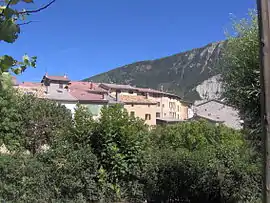 A general view of the village of La Mure-Argens | |
 Coat of arms | |
Location of La Mure-Argens 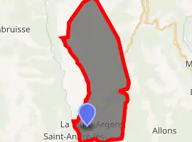
| |
 La Mure-Argens  La Mure-Argens | |
| Coordinates: 43°58′50″N 6°31′17″E | |
| Country | France |
| Region | Provence-Alpes-Côte d'Azur |
| Department | Alpes-de-Haute-Provence |
| Arrondissement | Castellane |
| Canton | Castellane |
| Intercommunality | Moyen Verdon |
| Government | |
| • Mayor (2008–2014) | Pierre Blanc |
| Area 1 | 34.73 km2 (13.41 sq mi) |
| Population (2017-01-01)[1] | 325 |
| • Density | 9.4/km2 (24/sq mi) |
| Time zone | UTC+01:00 (CET) |
| • Summer (DST) | UTC+02:00 (CEST) |
| INSEE/Postal code | 04136 /04170 |
| Elevation | 890–2,120 m (2,920–6,960 ft) (avg. 918 m or 3,012 ft) |
| 1 French Land Register data, which excludes lakes, ponds, glaciers > 1 km2 (0.386 sq mi or 247 acres) and river estuaries. | |
Population
| Year | Pop. | ±% |
|---|---|---|
| 1765 | 247 | — |
| 1793 | 275 | +11.3% |
| 1800 | 228 | −17.1% |
| 1806 | 295 | +29.4% |
| 1821 | 272 | −7.8% |
| 1831 | 301 | +10.7% |
| 1836 | 325 | +8.0% |
| 1841 | 306 | −5.8% |
| 1846 | 347 | +13.4% |
| 1851 | 314 | −9.5% |
| 1856 | 320 | +1.9% |
| 1861 | 325 | +1.6% |
| 1866 | 287 | −11.7% |
| 1872 | 289 | +0.7% |
| 1876 | 249 | −13.8% |
| 1881 | 255 | +2.4% |
| 1886 | 253 | −0.8% |
| 1891 | 252 | −0.4% |
| 1896 | 230 | −8.7% |
| 1901 | 208 | −9.6% |
| 1906 | 323 | +55.3% |
| 1911 | 223 | −31.0% |
| 1921 | 168 | −24.7% |
| 1926 | 139 | −17.3% |
| 1931 | 149 | +7.2% |
| 1936 | 145 | −2.7% |
| 1946 | 141 | −2.8% |
| 1954 | 139 | −1.4% |
| 1962 | 140 | +0.7% |
| 1968 | 141 | +0.7% |
| 1975 | 172 | +22.0% |
| 1982 | 209 | +21.5% |
| 1990 | 233 | +11.5% |
| 1999 | 249 | +6.9% |
| 2008 | 321 | +28.9% |
References
- "Populations légales 2017". INSEE. Retrieved 6 January 2020.
| Wikimedia Commons has media related to La Mure-Argens. |
This article is issued from Wikipedia. The text is licensed under Creative Commons - Attribution - Sharealike. Additional terms may apply for the media files.