Montclar, Alpes-de-Haute-Provence
Montclar is a commune in the Alpes-de-Haute-Provence department in southeastern France.
Montclar | |
|---|---|
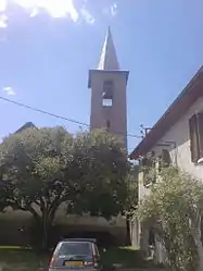 The church of Saint-Michel, in Serre Nauzet | |
 Coat of arms | |
Location of Montclar 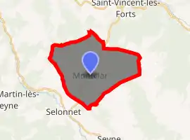
| |
 Montclar  Montclar | |
| Coordinates: 44°23′52″N 6°20′18″E | |
| Country | France |
| Region | Provence-Alpes-Côte d'Azur |
| Department | Alpes-de-Haute-Provence |
| Arrondissement | Digne-les-Bains |
| Canton | Seyne |
| Intercommunality | Pays de Seyne |
| Government | |
| • Mayor (2008–2014) | Henri Savornin |
| Area 1 | 23.38 km2 (9.03 sq mi) |
| Population (2017-01-01)[1] | 414 |
| • Density | 18/km2 (46/sq mi) |
| Time zone | UTC+01:00 (CET) |
| • Summer (DST) | UTC+02:00 (CEST) |
| INSEE/Postal code | 04126 /04140 |
| Elevation | 1,082–2,500 m (3,550–8,202 ft) (avg. 1,120 m or 3,670 ft) |
| 1 French Land Register data, which excludes lakes, ponds, glaciers > 1 km2 (0.386 sq mi or 247 acres) and river estuaries. | |
Population
| Year | Pop. | ±% |
|---|---|---|
| 1765 | 629 | — |
| 1793 | 675 | +7.3% |
| 1800 | 591 | −12.4% |
| 1806 | 605 | +2.4% |
| 1821 | 538 | −11.1% |
| 1831 | 591 | +9.9% |
| 1836 | 595 | +0.7% |
| 1841 | 590 | −0.8% |
| 1846 | 616 | +4.4% |
| 1851 | 612 | −0.6% |
| 1856 | 599 | −2.1% |
| 1861 | 570 | −4.8% |
| 1866 | 568 | −0.4% |
| 1872 | 551 | −3.0% |
| 1876 | 536 | −2.7% |
| 1881 | 509 | −5.0% |
| 1886 | 529 | +3.9% |
| 1891 | 442 | −16.4% |
| 1896 | 419 | −5.2% |
| 1901 | 386 | −7.9% |
| 1906 | 345 | −10.6% |
| 1911 | 379 | +9.9% |
| 1921 | 354 | −6.6% |
| 1926 | 307 | −13.3% |
| 1931 | 303 | −1.3% |
| 1936 | 304 | +0.3% |
| 1946 | 282 | −7.2% |
| 1954 | 268 | −5.0% |
| 1962 | 229 | −14.6% |
| 1968 | 204 | −10.9% |
| 1975 | 220 | +7.8% |
| 1982 | 258 | +17.3% |
| 1990 | 327 | +26.7% |
| 1999 | 399 | +22.0% |
| 2008 | 458 | +14.8% |
References
- "Populations légales 2017". INSEE. Retrieved 6 January 2020.
| Wikimedia Commons has media related to Montclar, Alpes-de-Haute-Provence. |
This article is issued from Wikipedia. The text is licensed under Creative Commons - Attribution - Sharealike. Additional terms may apply for the media files.