Enchastrayes
Enchastrayes is a commune in the Alpes-de-Haute-Provence department in southeastern France.
Enchastrayes | |
|---|---|
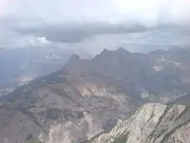 The summit of the Chapeau de Gendarme (Gendarme Hat) south-west of Enchastrayes | |
Location of Enchastrayes 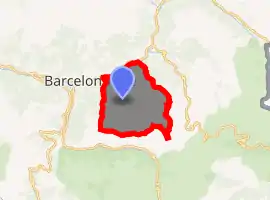
| |
 Enchastrayes  Enchastrayes | |
| Coordinates: 44°22′06″N 6°41′45″E | |
| Country | France |
| Region | Provence-Alpes-Côte d'Azur |
| Department | Alpes-de-Haute-Provence |
| Arrondissement | Barcelonnette |
| Canton | Barcelonnette |
| Government | |
| • Mayor (2008–2014) | Albert Olivero |
| Area 1 | 44.19 km2 (17.06 sq mi) |
| Population (2017-01-01)[1] | 396 |
| • Density | 9.0/km2 (23/sq mi) |
| Time zone | UTC+01:00 (CET) |
| • Summer (DST) | UTC+02:00 (CEST) |
| INSEE/Postal code | 04073 /04400 |
| Elevation | 1,151–2,775 m (3,776–9,104 ft) (avg. 1,450 m or 4,760 ft) |
| 1 French Land Register data, which excludes lakes, ponds, glaciers > 1 km2 (0.386 sq mi or 247 acres) and river estuaries. | |
The Enciastraia mountain is located in the communal territory, on the boundary with Piedmont, part of northern Italy.
Population
|
|
References
- "Populations légales 2017". INSEE. Retrieved 6 January 2020.
| Wikimedia Commons has media related to Enchastrayes. |
This article is issued from Wikipedia. The text is licensed under Creative Commons - Attribution - Sharealike. Additional terms may apply for the media files.