Saint-Étienne-les-Orgues
Saint-Étienne-les-Orgues is a commune in the Alpes-de-Haute-Provence department in southeastern France.
Saint-Étienne-les-Orgues | |
|---|---|
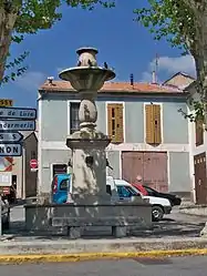 The fountain in Saint-Étienne-les-Orgues | |
 Coat of arms | |
Location of Saint-Étienne-les-Orgues 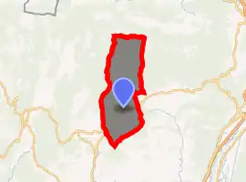
| |
 Saint-Étienne-les-Orgues  Saint-Étienne-les-Orgues | |
| Coordinates: 44°02′48″N 5°46′52″E | |
| Country | France |
| Region | Provence-Alpes-Côte d'Azur |
| Department | Alpes-de-Haute-Provence |
| Arrondissement | Forcalquier |
| Canton | Forcalquier |
| Intercommunality | Pays de Forcalquier et Montagne de Lure |
| Government | |
| • Mayor (2008–2014) | Guy Piana |
| Area 1 | 48.42 km2 (18.70 sq mi) |
| Population (2017-01-01)[1] | 1,296 |
| • Density | 27/km2 (69/sq mi) |
| Time zone | UTC+01:00 (CET) |
| • Summer (DST) | UTC+02:00 (CEST) |
| INSEE/Postal code | 04178 /04230 |
| Elevation | 549–1,825 m (1,801–5,988 ft) (avg. 687 m or 2,254 ft) |
| 1 French Land Register data, which excludes lakes, ponds, glaciers > 1 km2 (0.386 sq mi or 247 acres) and river estuaries. | |
Population
| Year | Pop. | ±% |
|---|---|---|
| 1765 | 880 | — |
| 1793 | 880 | +0.0% |
| 1800 | 984 | +11.8% |
| 1806 | 942 | −4.3% |
| 1821 | 1,083 | +15.0% |
| 1831 | 1,169 | +7.9% |
| 1836 | 1,326 | +13.4% |
| 1841 | 1,208 | −8.9% |
| 1846 | 1,176 | −2.6% |
| 1851 | 1,200 | +2.0% |
| 1856 | 1,150 | −4.2% |
| 1861 | 1,115 | −3.0% |
| 1866 | 1,039 | −6.8% |
| 1872 | 1,039 | +0.0% |
| 1876 | 1,038 | −0.1% |
| 1881 | 1,002 | −3.5% |
| 1886 | 930 | −7.2% |
| 1891 | 878 | −5.6% |
| 1896 | 833 | −5.1% |
| 1901 | 770 | −7.6% |
| 1906 | 768 | −0.3% |
| 1911 | 851 | +10.8% |
| 1921 | 682 | −19.9% |
| 1926 | 650 | −4.7% |
| 1931 | 580 | −10.8% |
| 1936 | 568 | −2.1% |
| 1946 | 521 | −8.3% |
| 1954 | 507 | −2.7% |
| 1962 | 477 | −5.9% |
| 1968 | 478 | +0.2% |
| 1975 | 561 | +17.4% |
| 1982 | 679 | +21.0% |
| 1990 | 1,091 | +60.7% |
| 1999 | 873 | −20.0% |
| 2008 | 1,222 | +40.0% |
References
- "Populations légales 2017". INSEE. Retrieved 6 January 2020.
External links
| Wikimedia Commons has media related to Saint-Étienne-les-Orgues. |
| Authority control |
|
|---|
This article is issued from Wikipedia. The text is licensed under Creative Commons - Attribution - Sharealike. Additional terms may apply for the media files.