Saint-Laurent-du-Verdon
Saint-Laurent-du-Verdon is a commune in the Alpes-de-Haute-Provence department in southeastern France.
Saint-Laurent-du-Verdon | |
|---|---|
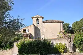 The Romanesque chapel in Saint-Laurent-du-Verdon | |
 Coat of arms | |
Location of Saint-Laurent-du-Verdon 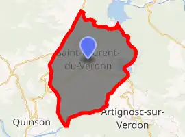
| |
 Saint-Laurent-du-Verdon  Saint-Laurent-du-Verdon | |
| Coordinates: 43°43′30″N 6°04′07″E | |
| Country | France |
| Region | Provence-Alpes-Côte d'Azur |
| Department | Alpes-de-Haute-Provence |
| Arrondissement | Forcalquier |
| Canton | Valensole |
| Government | |
| • Mayor (2008–2014) | Jean-Albert Bondil |
| Area 1 | 8.89 km2 (3.43 sq mi) |
| Population (2017-01-01)[1] | 97 |
| • Density | 11/km2 (28/sq mi) |
| Time zone | UTC+01:00 (CET) |
| • Summer (DST) | UTC+02:00 (CEST) |
| INSEE/Postal code | 04186 /04500 |
| Elevation | 394–581 m (1,293–1,906 ft) (avg. 468 m or 1,535 ft) |
| 1 French Land Register data, which excludes lakes, ponds, glaciers > 1 km2 (0.386 sq mi or 247 acres) and river estuaries. | |
Population
| Year | Pop. | ±% |
|---|---|---|
| 1765 | 208 | — |
| 1793 | 188 | −9.6% |
| 1800 | 205 | +9.0% |
| 1806 | 182 | −11.2% |
| 1821 | 186 | +2.2% |
| 1831 | 206 | +10.8% |
| 1836 | 216 | +4.9% |
| 1841 | 159 | −26.4% |
| 1846 | 162 | +1.9% |
| 1851 | 169 | +4.3% |
| 1856 | 137 | −18.9% |
| 1861 | 145 | +5.8% |
| 1866 | 162 | +11.7% |
| 1872 | 159 | −1.9% |
| 1876 | 143 | −10.1% |
| 1881 | 139 | −2.8% |
| 1886 | 131 | −5.8% |
| 1891 | 111 | −15.3% |
| 1896 | 114 | +2.7% |
| 1901 | 105 | −7.9% |
| 1906 | 102 | −2.9% |
| 1911 | 111 | +8.8% |
| 1921 | 75 | −32.4% |
| 1926 | 75 | +0.0% |
| 1931 | 61 | −18.7% |
| 1936 | 49 | −19.7% |
| 1946 | 48 | −2.0% |
| 1954 | 58 | +20.8% |
| 1962 | 46 | −20.7% |
| 1968 | 52 | +13.0% |
| 1975 | 53 | +1.9% |
| 1982 | 59 | +11.3% |
| 1990 | 71 | +20.3% |
| 1999 | 74 | +4.2% |
| 2008 | 93 | +25.7% |
References
- "Populations légales 2017". INSEE. Retrieved 6 January 2020.
| Wikimedia Commons has media related to Saint-Laurent-du-Verdon. |
This article is issued from Wikipedia. The text is licensed under Creative Commons - Attribution - Sharealike. Additional terms may apply for the media files.