Colmars
Colmars or Colmars-les-Alpes (Còumars in provençal) is a commune in the Alpes-de-Haute-Provence department in southeastern France.
Colmars | |
|---|---|
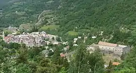 An overall view of the village of Colmars | |
 Coat of arms | |
Location of Colmars 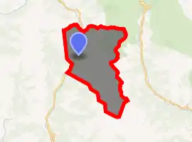
| |
 Colmars  Colmars | |
| Coordinates: 44°10′55″N 6°37′38″E | |
| Country | France |
| Region | Provence-Alpes-Côte d'Azur |
| Department | Alpes-de-Haute-Provence |
| Arrondissement | Castellane |
| Canton | Castellane |
| Government | |
| • Mayor (2008–2014) | Fernand Dyen |
| Area 1 | 81.82 km2 (31.59 sq mi) |
| Population (2017-01-01)[1] | 496 |
| • Density | 6.1/km2 (16/sq mi) |
| Time zone | UTC+01:00 (CET) |
| • Summer (DST) | UTC+02:00 (CEST) |
| INSEE/Postal code | 04061 /04370 |
| Elevation | 1,178–2,742 m (3,865–8,996 ft) (avg. 1,250 m or 4,100 ft) |
| 1 French Land Register data, which excludes lakes, ponds, glaciers > 1 km2 (0.386 sq mi or 247 acres) and river estuaries. | |
The official name of the commune, according to the geographical code of the INSEE, is "Colmars", but it is always referred locally as "Colmars-les-Alpes", even though it is not recognised in legal situations. The signs on entering the village read "Colmars-les-Alpes".
Geography
The village is situated at the confluence of the Verdon and Lance rivers, at an altitude of 1250 metres. The site of the village is a site inscrit, a site of special natural, scientific or historical interest.
Hamlets
There are two other hamlets in the commune: Clignon-Haut and Clignon-Bas.
Population
|
|
The inhabitants are called Colmarsiens.
Geography
Mountains and peaks
There are numerous high points in the commune. The main ones are:
- Tête de l'Encombrette (2682m)
- Autapie (2426m)
- Roche Cline
- Valpane
History
The name of the village comes from a hill dedicated to Mars by the Romans ("Collo Marto"). The village was originally situated further up a hill, but the site was judged to be too cramped and not possible to expand any further, so it was abandoned. It was destroyed by Raymond de Turenne in 1390.
Modern era
In the French Wars of Religion, the site was the target of several attacks:
- Paulon de Mauvans, a Protestant captain, pillaged the village in 1560;
- Cartier, a captain operating on behalf of de Mauvans, took and ransomed the village in 1583;
- The French Catholic League sacked the village a few years later.
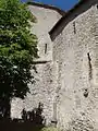
Gallery
References
- "Populations légales 2017". INSEE. Retrieved 6 January 2020.
External links
| Wikimedia Commons has media related to Colmars. |
| Authority control |
|---|