Malijai
Malijai is a commune in the Alpes-de-Haute-Provence department in southeastern France.
Malijai | |
|---|---|
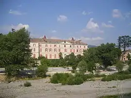 The chateau of Malijai | |
 Coat of arms | |
Location of Malijai 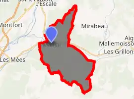
| |
 Malijai  Malijai | |
| Coordinates: 44°02′48″N 6°01′52″E | |
| Country | France |
| Region | Provence-Alpes-Côte d'Azur |
| Department | Alpes-de-Haute-Provence |
| Arrondissement | Digne-les-Bains |
| Canton | Digne-les-Bains-2 |
| Government | |
| • Mayor (2008–2014) | Eliane Barreille |
| Area 1 | 26.56 km2 (10.25 sq mi) |
| Population (2017-01-01)[1] | 1,975 |
| • Density | 74/km2 (190/sq mi) |
| Time zone | UTC+01:00 (CET) |
| • Summer (DST) | UTC+02:00 (CEST) |
| INSEE/Postal code | 04108 /04350 |
| Elevation | 422–1,080 m (1,385–3,543 ft) (avg. 428 m or 1,404 ft) |
| 1 French Land Register data, which excludes lakes, ponds, glaciers > 1 km2 (0.386 sq mi or 247 acres) and river estuaries. | |
Geography
The village lies on the right bank of the Bléone, which forms part of the commune's western border, then flows west through the northern part of the commune.
Population
|
|
References
- "Populations légales 2017". INSEE. Retrieved 6 January 2020.
| Wikimedia Commons has media related to Malijai. |
| Authority control |
|
|---|
This article is issued from Wikipedia. The text is licensed under Creative Commons - Attribution - Sharealike. Additional terms may apply for the media files.