Mézel
Mézel is a commune in the Alpes-de-Haute-Provence department in southeastern France.
Mézel | |
|---|---|
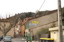 The main road in the village of Mézel | |
 Coat of arms | |
Location of Mézel 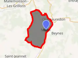
| |
 Mézel  Mézel | |
| Coordinates: 43°59′51″N 6°11′48″E | |
| Country | France |
| Region | Provence-Alpes-Côte d'Azur |
| Department | Alpes-de-Haute-Provence |
| Arrondissement | Digne-les-Bains |
| Canton | Riez |
| Intercommunality | Trois Vallées |
| Government | |
| • Mayor (2008–2014) | Pierre Suzor |
| Area 1 | 21.36 km2 (8.25 sq mi) |
| Population (2017-01-01)[1] | 656 |
| • Density | 31/km2 (80/sq mi) |
| Time zone | UTC+01:00 (CET) |
| • Summer (DST) | UTC+02:00 (CEST) |
| INSEE/Postal code | 04121 /04270 |
| Elevation | 537–971 m (1,762–3,186 ft) |
| 1 French Land Register data, which excludes lakes, ponds, glaciers > 1 km2 (0.386 sq mi or 247 acres) and river estuaries. | |
Geography
The village lies on the right bank of the Asse, which forms all of the communes eastern border.
Population
| Year | Pop. | ±% |
|---|---|---|
| 1765 | 656 | — |
| 1793 | 792 | +20.7% |
| 1800 | 709 | −10.5% |
| 1806 | 738 | +4.1% |
| 1821 | 819 | +11.0% |
| 1831 | 855 | +4.4% |
| 1836 | 903 | +5.6% |
| 1841 | 985 | +9.1% |
| 1846 | 963 | −2.2% |
| 1851 | 869 | −9.8% |
| 1856 | 811 | −6.7% |
| 1861 | 805 | −0.7% |
| 1866 | 806 | +0.1% |
| 1872 | 772 | −4.2% |
| 1876 | 774 | +0.3% |
| 1881 | 794 | +2.6% |
| 1886 | 929 | +17.0% |
| 1891 | 841 | −9.5% |
| 1896 | 695 | −17.4% |
| 1901 | 651 | −6.3% |
| 1906 | 649 | −0.3% |
| 1911 | 626 | −3.5% |
| 1921 | 516 | −17.6% |
| 1926 | 519 | +0.6% |
| 1931 | 525 | +1.2% |
| 1936 | 515 | −1.9% |
| 1946 | 404 | −21.6% |
| 1954 | 368 | −8.9% |
| 1962 | 363 | −1.4% |
| 1968 | 346 | −4.7% |
| 1975 | 326 | −5.8% |
| 1982 | 335 | +2.8% |
| 1990 | 423 | +26.3% |
| 1999 | 536 | +26.7% |
| 2008 | 660 | +23.1% |
References
| Wikimedia Commons has media related to Mézel. |
- "Populations légales 2017". INSEE. Retrieved 6 January 2020.
This article is issued from Wikipedia. The text is licensed under Creative Commons - Attribution - Sharealike. Additional terms may apply for the media files.