Clumanc
Clumanc is a commune in the Alpes-de-Haute-Provence department in southeastern France.
Clumanc | |
|---|---|
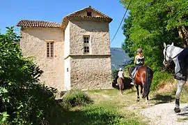 Chateau | |
 Coat of arms | |
Location of Clumanc 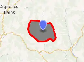
| |
 Clumanc  Clumanc | |
| Coordinates: 44°01′28″N 6°23′02″E | |
| Country | France |
| Region | Provence-Alpes-Côte d'Azur |
| Department | Alpes-de-Haute-Provence |
| Arrondissement | Castellane |
| Canton | Riez |
| Intercommunality | Moyen Verdon |
| Government | |
| • Mayor (2008–2014) | Bernard Molling |
| Area 1 | 53.68 km2 (20.73 sq mi) |
| Population (2017-01-01)[1] | 215 |
| • Density | 4.0/km2 (10/sq mi) |
| Time zone | UTC+01:00 (CET) |
| • Summer (DST) | UTC+02:00 (CEST) |
| INSEE/Postal code | 04059 /04330 |
| Elevation | 773–1,703 m (2,536–5,587 ft) (avg. 800 m or 2,600 ft) |
| 1 French Land Register data, which excludes lakes, ponds, glaciers > 1 km2 (0.386 sq mi or 247 acres) and river estuaries. | |
Geography
The river Asse de Clumanc flows south through the commune.
Population
| Year | Pop. | ±% |
|---|---|---|
| 1765 | 793 | — |
| 1793 | 823 | +3.8% |
| 1800 | 808 | −1.8% |
| 1806 | 753 | −6.8% |
| 1821 | 940 | +24.8% |
| 1831 | 1,013 | +7.8% |
| 1836 | 1,052 | +3.8% |
| 1841 | 1,043 | −0.9% |
| 1846 | 1,115 | +6.9% |
| 1851 | 1,090 | −2.2% |
| 1856 | 1,040 | −4.6% |
| 1861 | 1,039 | −0.1% |
| 1866 | 919 | −11.5% |
| 1872 | 842 | −8.4% |
| 1876 | 859 | +2.0% |
| 1881 | 772 | −10.1% |
| 1886 | 755 | −2.2% |
| 1891 | 710 | −6.0% |
| 1896 | 611 | −13.9% |
| 1901 | 560 | −8.3% |
| 1906 | 506 | −9.6% |
| 1911 | 501 | −1.0% |
| 1921 | 418 | −16.6% |
| 1926 | 341 | −18.4% |
| 1931 | 315 | −7.6% |
| 1936 | 276 | −12.4% |
| 1946 | 250 | −9.4% |
| 1954 | 247 | −1.2% |
| 1962 | 199 | −19.4% |
| 1968 | 177 | −11.1% |
| 1975 | 135 | −23.7% |
| 1982 | 137 | +1.5% |
| 1990 | 156 | +13.9% |
| 1999 | 154 | −1.3% |
| 2008 | 169 | +9.7% |
References
- "Populations légales 2017". INSEE. Retrieved 6 January 2020.
| Wikimedia Commons has media related to Clumanc. |
This article is issued from Wikipedia. The text is licensed under Creative Commons - Attribution - Sharealike. Additional terms may apply for the media files.