Sainte-Tulle
Sainte-Tulle (Occitan; Santa Túllia) is a commune in the Alpes-de-Haute-Provence department in southeastern France.
Sainte-Tulle | |
|---|---|
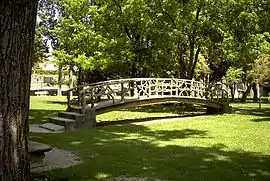 Petrified bridge | |
 Coat of arms | |
Location of Sainte-Tulle 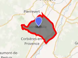
| |
 Sainte-Tulle  Sainte-Tulle | |
| Coordinates: 43°47′12″N 5°45′57″E | |
| Country | France |
| Region | Provence-Alpes-Côte d'Azur |
| Department | Alpes-de-Haute-Provence |
| Arrondissement | Forcalquier |
| Canton | Manosque-3 |
| Intercommunality | Sud 4 |
| Government | |
| • Mayor (2008–2014) | Yannick Philipponneau |
| Area 1 | 17.07 km2 (6.59 sq mi) |
| Population (2017-01-01)[1] | 3,408 |
| • Density | 200/km2 (520/sq mi) |
| Time zone | UTC+01:00 (CET) |
| • Summer (DST) | UTC+02:00 (CEST) |
| INSEE/Postal code | 04197 /04220 |
| Elevation | 269–521 m (883–1,709 ft) (avg. 299 m or 981 ft) |
| 1 French Land Register data, which excludes lakes, ponds, glaciers > 1 km2 (0.386 sq mi or 247 acres) and river estuaries. | |
Population
| Year | Pop. | ±% |
|---|---|---|
| 1765 | 789 | — |
| 1793 | 741 | −6.1% |
| 1800 | 863 | +16.5% |
| 1806 | 972 | +12.6% |
| 1821 | 1,072 | +10.3% |
| 1831 | 1,164 | +8.6% |
| 1836 | 1,081 | −7.1% |
| 1841 | 1,001 | −7.4% |
| 1846 | 924 | −7.7% |
| 1851 | 896 | −3.0% |
| 1856 | 960 | +7.1% |
| 1861 | 887 | −7.6% |
| 1866 | 850 | −4.2% |
| 1872 | 802 | −5.6% |
| 1876 | 790 | −1.5% |
| 1881 | 718 | −9.1% |
| 1886 | 647 | −9.9% |
| 1891 | 636 | −1.7% |
| 1896 | 624 | −1.9% |
| 1901 | 667 | +6.9% |
| 1906 | 662 | −0.7% |
| 1911 | 683 | +3.2% |
| 1921 | 1,515 | +121.8% |
| 1926 | 1,149 | −24.2% |
| 1931 | 1,237 | +7.7% |
| 1936 | 1,224 | −1.1% |
| 1946 | 1,365 | +11.5% |
| 1954 | 1,635 | +19.8% |
| 1962 | 1,857 | +13.6% |
| 1968 | 2,458 | +32.4% |
| 1975 | 2,520 | +2.5% |
| 1982 | 2,805 | +11.3% |
| 1990 | 2,855 | +1.8% |
| 1999 | 3,055 | +7.0% |
| 2008 | 3,265 | +6.9% |
References
- "Populations légales 2017". INSEE. Retrieved 6 January 2020.
| Wikimedia Commons has media related to Sainte-Tulle. |
This article is issued from Wikipedia. The text is licensed under Creative Commons - Attribution - Sharealike. Additional terms may apply for the media files.