Montlaux
Montlaux is a commune in the Alpes-de-Haute-Provence department in southeastern France.
Montlaux | |
|---|---|
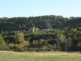 A farmhouse on a hill, near to old Montlaux | |
 Coat of arms | |
Location of Montlaux 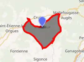
| |
 Montlaux  Montlaux | |
| Coordinates: 44°02′52″N 5°50′43″E | |
| Country | France |
| Region | Provence-Alpes-Côte d'Azur |
| Department | Alpes-de-Haute-Provence |
| Arrondissement | Forcalquier |
| Canton | Forcalquier |
| Intercommunality | Pays de Forcalquier et Montagne de Lure |
| Government | |
| • Mayor (2008–2014) | Claude Durand |
| Area 1 | 19.75 km2 (7.63 sq mi) |
| Population (2017-01-01)[1] | 195 |
| • Density | 9.9/km2 (26/sq mi) |
| Time zone | UTC+01:00 (CET) |
| • Summer (DST) | UTC+02:00 (CEST) |
| INSEE/Postal code | 04130 /04230 |
| Elevation | 492–807 m (1,614–2,648 ft) (avg. 550 m or 1,800 ft) |
| 1 French Land Register data, which excludes lakes, ponds, glaciers > 1 km2 (0.386 sq mi or 247 acres) and river estuaries. | |
It is a village peacefully situated on the edge of the Lauzon river, far from the main highways.
The village is unusual because it is very spread-out, contrary to most settlements in the area where the houses are clustered together with vast empty spaces on the outskirts.
Only in the small hamlet of Jacons will you find houses grouped together, along with the townhall and church.
Population
| Year | Pop. | ±% |
|---|---|---|
| 1765 | 227 | — |
| 1793 | 214 | −5.7% |
| 1800 | 292 | +36.4% |
| 1806 | 188 | −35.6% |
| 1821 | 190 | +1.1% |
| 1831 | 198 | +4.2% |
| 1836 | 267 | +34.8% |
| 1841 | 268 | +0.4% |
| 1846 | 351 | +31.0% |
| 1851 | 368 | +4.8% |
| 1856 | 394 | +7.1% |
| 1861 | 380 | −3.6% |
| 1866 | 350 | −7.9% |
| 1872 | 334 | −4.6% |
| 1876 | 322 | −3.6% |
| 1881 | 328 | +1.9% |
| 1886 | 272 | −17.1% |
| 1891 | 246 | −9.6% |
| 1896 | 258 | +4.9% |
| 1901 | 242 | −6.2% |
| 1906 | 249 | +2.9% |
| 1911 | 220 | −11.6% |
| 1921 | 172 | −21.8% |
| 1926 | 145 | −15.7% |
| 1931 | 105 | −27.6% |
| 1936 | 125 | +19.0% |
| 1946 | 128 | +2.4% |
| 1954 | 100 | −21.9% |
| 1962 | 89 | −11.0% |
| 1968 | 87 | −2.2% |
| 1975 | 91 | +4.6% |
| 1982 | 118 | +29.7% |
| 1990 | 117 | −0.8% |
| 1999 | 132 | +12.8% |
| 2008 | 133 | +0.8% |
References
- "Populations légales 2017". INSEE. Retrieved 6 January 2020.
| Wikimedia Commons has media related to Montlaux. |
| Authority control |
|---|
This article is issued from Wikipedia. The text is licensed under Creative Commons - Attribution - Sharealike. Additional terms may apply for the media files.