Le Lauzet-Ubaye
Le Lauzet-Ubaye is a commune in the Alpes-de-Haute-Provence department in southeastern France.
Le Lauzet-Ubaye | |
|---|---|
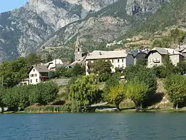 Buildings of Le Lauzet-Ubaye and the lake | |
Location of Le Lauzet-Ubaye 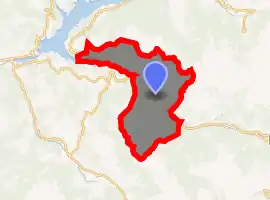
| |
 Le Lauzet-Ubaye  Le Lauzet-Ubaye | |
| Coordinates: 44°25′51″N 6°25′58″E | |
| Country | France |
| Region | Provence-Alpes-Côte d'Azur |
| Department | Alpes-de-Haute-Provence |
| Arrondissement | Barcelonnette |
| Canton | Barcelonnette |
| Intercommunality | Vallée de l'Ubaye |
| Government | |
| • Mayor (2008–2014) | Michel Lanfranchi |
| Area 1 | 66.26 km2 (25.58 sq mi) |
| Population (2017-01-01)[1] | 186 |
| • Density | 2.8/km2 (7.3/sq mi) |
| Time zone | UTC+01:00 (CET) |
| • Summer (DST) | UTC+02:00 (CEST) |
| INSEE/Postal code | 04102 /04340 |
| Elevation | 771–2,500 m (2,530–8,202 ft) (avg. 900 m or 3,000 ft) |
| 1 French Land Register data, which excludes lakes, ponds, glaciers > 1 km2 (0.386 sq mi or 247 acres) and river estuaries. | |
Population
| Year | Pop. | ±% |
|---|---|---|
| 1765 | 843 | — |
| 1793 | 855 | +1.4% |
| 1800 | 857 | +0.2% |
| 1806 | 881 | +2.8% |
| 1821 | 1,023 | +16.1% |
| 1831 | 1,020 | −0.3% |
| 1836 | 1,034 | +1.4% |
| 1841 | 913 | −11.7% |
| 1846 | 965 | +5.7% |
| 1851 | 919 | −4.8% |
| 1856 | 956 | +4.0% |
| 1861 | 931 | −2.6% |
| 1866 | 904 | −2.9% |
| 1872 | 867 | −4.1% |
| 1876 | 817 | −5.8% |
| 1881 | 810 | −0.9% |
| 1886 | 735 | −9.3% |
| 1891 | 707 | −3.8% |
| 1896 | 653 | −7.6% |
| 1901 | 642 | −1.7% |
| 1906 | 629 | −2.0% |
| 1911 | 668 | +6.2% |
| 1921 | 735 | +10.0% |
| 1926 | 606 | −17.6% |
| 1931 | 599 | −1.2% |
| 1936 | 442 | −26.2% |
| 1946 | 373 | −15.6% |
| 1954 | 329 | −11.8% |
| 1962 | 293 | −10.9% |
| 1968 | 253 | −13.7% |
| 1975 | 221 | −12.6% |
| 1982 | 241 | +9.0% |
| 1990 | 212 | −12.0% |
| 1999 | 203 | −4.2% |
| 2008 | 230 | +13.3% |
References
- "Populations légales 2017". INSEE. Retrieved 6 January 2020.
| Wikimedia Commons has media related to Le Lauzet-Ubaye. |
| Authority control |
|
|---|
This article is issued from Wikipedia. The text is licensed under Creative Commons - Attribution - Sharealike. Additional terms may apply for the media files.