Saint-Julien-d'Asse
Saint-Julien-d'Asse is a commune in the Alpes-de-Haute-Provence department in southeastern France.
Saint-Julien-d'Asse | |
|---|---|
.JPG.webp) The Asse Valley and the Plateau de Valensole | |
 Coat of arms | |
Location of Saint-Julien-d'Asse 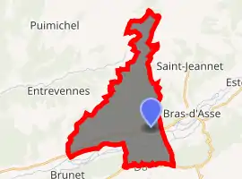
| |
 Saint-Julien-d'Asse  Saint-Julien-d'Asse | |
| Coordinates: 43°55′06″N 6°05′41″E | |
| Country | France |
| Region | Provence-Alpes-Côte d'Azur |
| Department | Alpes-de-Haute-Provence |
| Arrondissement | Digne-les-Bains |
| Canton | Riez |
| Government | |
| • Mayor (2008–2014) | Jean-Pierre Aillaud |
| Area 1 | 25.6 km2 (9.9 sq mi) |
| Population (2017-01-01)[1] | 212 |
| • Density | 8.3/km2 (21/sq mi) |
| Time zone | UTC+01:00 (CET) |
| • Summer (DST) | UTC+02:00 (CEST) |
| INSEE/Postal code | 04182 /04270 |
| Elevation | 407–886 m (1,335–2,907 ft) (avg. 484 m or 1,588 ft) |
| 1 French Land Register data, which excludes lakes, ponds, glaciers > 1 km2 (0.386 sq mi or 247 acres) and river estuaries. | |
Geography
The village lies on the right bank of the Asse, which flows west through the southern part of the commune.
Population
|
|
References
- "Populations légales 2017". INSEE. Retrieved 6 January 2020.
| Wikimedia Commons has media related to Saint-Julien-d'Asse. |
This article is issued from Wikipedia. The text is licensed under Creative Commons - Attribution - Sharealike. Additional terms may apply for the media files.