Blaine County, Nebraska
Blaine County is a county in the U.S. state of Nebraska. As of the 2010 United States Census, the population was 478,[1] making it Nebraska's second-least populous county and the sixth-least populous in the United States. Its county seat is Brewster.[2] The county was formed in 1885[3] and organized in 1886.[4] It is named after presidential candidate James G. Blaine.[5]
Blaine County | |
|---|---|
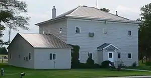 Blaine County Courthouse in Brewster | |
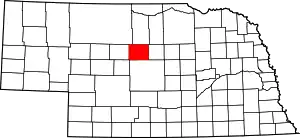 Location within the U.S. state of Nebraska | |
 Nebraska's location within the U.S. | |
| Coordinates: 41°56′N 99°59′W | |
| Country | |
| State | |
| Founded | 1885 (authorized) 1886 (organized) |
| Named for | James G. Blaine |
| Seat | Brewster |
| Largest village | Dunning |
| Area | |
| • Total | 714 sq mi (1,850 km2) |
| • Land | 711 sq mi (1,840 km2) |
| • Water | 3.6 sq mi (9 km2) 0.5%% |
| Population | |
| • Estimate (2018) | 476 |
| • Density | 0.7/sq mi (0.3/km2) |
| Time zone | UTC−6 (Central) |
| • Summer (DST) | UTC−5 (CDT) |
| Congressional district | 3rd |
| Website | www |
In the Nebraska license plate system, Blaine County is represented by the prefix 86 (it had the 86th-largest number of vehicles registered in the state when the license plate system was established in 1922).
Geography
According to the US Census Bureau, the county has an area of 715 square miles (1,850 km2), of which 711 square miles (1,840 km2) is land and 3.6 square miles (9.3 km2) (0.5%) is water.[6]
Major highways
Adjacent counties
- Loup County – east
- Custer County – south
- Logan County – southwest
- Thomas County – west
- Cherry County – northwest
- Brown County – north
National protected area
- Nebraska National Forest (part)
Demographics
| Historical population | |||
|---|---|---|---|
| Census | Pop. | %± | |
| 1890 | 1,146 | — | |
| 1900 | 603 | −47.4% | |
| 1910 | 1,672 | 177.3% | |
| 1920 | 1,778 | 6.3% | |
| 1930 | 1,584 | −10.9% | |
| 1940 | 1,538 | −2.9% | |
| 1950 | 1,203 | −21.8% | |
| 1960 | 1,016 | −15.5% | |
| 1970 | 847 | −16.6% | |
| 1980 | 867 | 2.4% | |
| 1990 | 675 | −22.1% | |
| 2000 | 583 | −13.6% | |
| 2010 | 478 | −18.0% | |
| 2018 (est.) | 476 | [7] | −0.4% |
| US Decennial Census[8] 1790-1960[9] 1900-1990[10] 1990-2000[11] 2010-2013[1] | |||
As of the 2000 United States Census,[12] there were 583 people, 238 households, and 168 families in the county. The population density was 0.82 person per square mile (0.32/km2). There were 333 housing units at an average density of 0.5 per square mile (0.2/km2). The racial makeup of the county was 98.97% White, 0.51% Native American, and 0.51% from two or more races; 0.17% of the population were Hispanic or Latino of any race. 45.1% were of German, 12.2% English, 10.2% Irish and 8.4% American ancestry.
There were 238 households, of which 30.30% had children under the age of 18 living with them, 66.00% were married couples living together, 2.50% had a female householder with no husband present, and 29.00% were non-families. 26.90% of all households were made up of individuals, and 13.90% had someone living alone who was 65 years of age or older. The average household size was 2.45 and the average family size was 2.98.
The county population contained 26.20% under the age of 18, 3.90% from 18 to 24, 26.60% from 25 to 44, 26.40% from 45 to 64, and 16.80% who were 65 years of age or older. The median age was 40 years. For every 100 females there were 101.70 males. For every 100 females age 18 and over, there were 100.90 males.
The median income for a household in the county was $25,278, and the median income for a family was $28,472. Males had a median income of $17,917 versus $20,000 for females. The per capita income for the county was $12,323. About 18.70% of families and 19.40% of the population were below the poverty line, including 21.70% of those under age 18 and 9.40% of those age 65 or over.
Religion
More than 25% of the residents of Blaine County belong to The Church of Jesus Christ of Latter-day Saints. No other county in the state — or anywhere else so far east in the country — has more than 25% membership.[13] This however may actually reflect an oddity in the system used to come to these numbers more than it does reality. Every adjacent county is in the category "none reported" and the method used to get the numbers involved seems to be built around taking the membership numbers of all wards and branches in the county and assigning all those people to the county. This method does not work when a ward or branch covers multiple counties.[14]
Communities
Politics
Blaine County voters are strongly Republican. In only four national elections since 1900 has the county selected the Democratic Party candidate, & none since 1936.
| Year | Republican | Democratic | Third Parties |
|---|---|---|---|
| 2020 | 88.3% 280 | 11.0% 35 | 0.6% 2 |
| 2016 | 87.1% 276 | 9.5% 30 | 3.5% 11 |
| 2012 | 88.5% 268 | 9.6% 29 | 2.0% 6 |
| 2008 | 84.2% 266 | 13.6% 43 | 2.2% 7 |
| 2004 | 88.8% 301 | 11.2% 38 | 0.0% 0 |
| 2000 | 85.7% 299 | 12.3% 43 | 2.0% 7 |
| 1996 | 75.1% 284 | 14.0% 53 | 10.9% 41 |
| 1992 | 56.5% 256 | 14.1% 64 | 29.4% 133 |
| 1988 | 82.2% 338 | 17.5% 72 | 0.2% 1 |
| 1984 | 88.3% 363 | 11.7% 48 | 0.0% 0 |
| 1980 | 81.7% 361 | 14.3% 63 | 4.1% 18 |
| 1976 | 66.6% 281 | 31.5% 133 | 1.9% 8 |
| 1972 | 86.0% 343 | 14.0% 56 | 0.0% 0 |
| 1968 | 79.5% 344 | 14.8% 64 | 5.8% 25 |
| 1964 | 62.6% 326 | 37.4% 195 | 0.0% 0 |
| 1960 | 78.8% 420 | 21.2% 113 | 0.0% 0 |
| 1956 | 73.6% 416 | 26.4% 149 | 0.0% 0 |
| 1952 | 77.0% 458 | 23.0% 137 | 0.0% 0 |
| 1948 | 50.4% 252 | 49.6% 248 | 0.0% 0 |
| 1944 | 59.6% 366 | 40.4% 248 | 0.0% 0 |
| 1940 | 59.4% 454 | 40.7% 311 | 0.0% 0 |
| 1936 | 47.8% 342 | 51.0% 365 | 1.3% 9 |
| 1932 | 35.4% 244 | 62.6% 431 | 2.0% 14 |
| 1928 | 73.1% 484 | 26.4% 175 | 0.5% 3 |
| 1924 | 43.4% 253 | 22.6% 132 | 34.0% 198 |
| 1920 | 63.8% 328 | 34.2% 176 | 2.0% 10 |
| 1916 | 40.7% 184 | 54.4% 246 | 4.9% 22 |
| 1912 | 29.0% 126 | 37.6% 163 | 33.4% 145 |
| 1908 | 56.1% 220 | 40.8% 160 | 3.1% 12 |
| 1904 | 70.2% 127 | 18.8% 34 | 11.1% 20 |
| 1900 | 57.5% 103 | 41.9% 75 | 0.6% 1 |
References
- "State & County QuickFacts". US Census Bureau. Archived from the original on July 7, 2011. Retrieved September 17, 2013.
- "Find a County". National Association of Counties. Archived from the original on May 31, 2011. Retrieved June 7, 2011.
- Fitzpatrick, Lillian L. (1960). Nebraska Place-Names. University of Nebraska Press. p. 18. ISBN 0803250606.
- "Nebraska Historic Buildings Survey" (PDF). Nebraska State Historical Society. May 15, 1989. Retrieved December 13, 2014.
- "Blaine County - History". Archived from the original on July 4, 2008. Retrieved March 16, 2008.
- "2010 Census Gazetteer Files". US Census Bureau. August 22, 2012. Archived from the original on November 13, 2013. Retrieved December 6, 2014.
- "Population and Housing Unit Estimates". Retrieved December 28, 2019.
- "US Decennial Census". US Census Bureau. Retrieved December 6, 2014.
- "Historical Census Browser". University of Virginia Library. Retrieved December 6, 2014.
- "Population of Counties by Decennial Census: 1900 to 1990". United States Census Bureau. Retrieved December 6, 2014.
- "Census 2000 PHC-T-4. Ranking Tables for Counties: 1990 and 2000" (PDF). US Census Bureau. Retrieved December 6, 2014.
- "U.S. Census website". US Census Bureau. Retrieved January 31, 2008.
- The source used to come to this information, listed in the next footnote, has categories "over 50.1%", "25.1% to 50.0%", "10.1% to 25.0%", "0.1% to 10.0%" and "none reported". There is one county in Iowa and one in the Florida Panhandle which are in the 10.1% to 25.0%, the differences in percentages can not be determined from this source, and the source may not really support what it claims, which is pointed out in the text.
- Valporaiso University produced map of percentages of Latter-day Saints by county Archived January 10, 2006, at the Wayback Machine
- http://uselectionatlas.org/RESULTS
Places adjacent to Blaine County, Nebraska | ||||||||||
|---|---|---|---|---|---|---|---|---|---|---|
| ||||||||||
Municipalities and communities of Blaine County, Nebraska, United States | ||
|---|---|---|
| Villages | Map of Nebraska highlighting Blaine County | |
| Unincorporated communities | ||
| Footnotes | ‡This populated place also has portions in an adjacent county or counties | |
| ||
