Logan County, Nebraska
Logan County is a county in the U.S. state of Nebraska. As of the 2010 United States Census, the population was 763.[1] Its county seat is Stapleton.[2]
Logan County | |
|---|---|
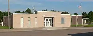 Logan County Courthouse in Stapleton | |
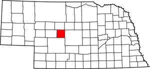 Location within the U.S. state of Nebraska | |
 Nebraska's location within the U.S. | |
| Coordinates: 41°34′N 100°29′W | |
| Country | |
| State | |
| Founded | 1885 |
| Named for | John A. Logan |
| Seat | Stapleton |
| Largest village | Stapleton |
| Area | |
| • Total | 571 sq mi (1,480 km2) |
| • Land | 571 sq mi (1,480 km2) |
| • Water | 0.5 sq mi (1 km2) 0.08%% |
| Population | |
| • Estimate (2017) | 768 |
| • Density | 1.35/sq mi (0.52/km2) |
| Time zone | UTC−6 (Central) |
| • Summer (DST) | UTC−5 (CDT) |
| Congressional district | 3rd |
| Website | logancounty |
Logan County is part of the North Platte, NE Micropolitan Statistical Area.
In the Nebraska license plate system, Logan County is represented by the prefix 87 (it had the eighty-seventh-largest number of vehicles registered in the county when the license plate system was established in 1922).
History
Logan County was formed in 1885. It was named for Civil War General John A. Logan.[3]
The first railroad was built through Logan County in 1911.[4]
Geography
The terrain of Logan County consists of low corrugated flatland, sparsely used for agricultural purposes at present. The ground slopes to the east-northeast,[5] with precipitation runoff making its way to the Dismal River north of Logan County.[6] The county has a total area of 571 square miles (1,480 km2), of which 571 square miles (1,480 km2) is land and 0.5 square miles (1.3 km2) (0.08%) is water.[7]
Major highways
 U.S. Highway 83
 Nebraska Highway 92
Adjacent counties
- Thomas County - north
- Blaine County - northeast
- Custer County - east
- Lincoln County - south
- McPherson County - west
Demographics
| Historical population | |||
|---|---|---|---|
| Census | Pop. | %± | |
| 1890 | 1,378 | — | |
| 1900 | 960 | −30.3% | |
| 1910 | 1,521 | 58.4% | |
| 1920 | 1,596 | 4.9% | |
| 1930 | 1,014 | −36.5% | |
| 1940 | 1,742 | 71.8% | |
| 1950 | 1,357 | −22.1% | |
| 1960 | 1,108 | −18.3% | |
| 1970 | 991 | −10.6% | |
| 1980 | 983 | −0.8% | |
| 1990 | 878 | −10.7% | |
| 2000 | 774 | −11.8% | |
| 2010 | 763 | −1.4% | |
| 2017 (est.) | 768 | [8] | 0.7% |
| US Decennial Census[9] 1790-1960[10] 1900-1990[11] 1990-2000[12] 2010-2013[1] | |||
As of the 2000 United States Census,[13] there 774 people, 316 households, and 229 families residing in the county. The population density was 1 people per square mile (1/km2). There were 386 housing units at an average density of 1 per square mile (0/km2). The racial makeup of the county was 98.58% White, 0.13% Black or African American, 1.03% Native American, and 0.26% from two or more races. 0.90% of the population were Hispanic or Latino of any race.
There were 316 households, out of which 29.70% had children under the age of 18 living with them, 66.50% were married couples living together, 3.80% had a female householder with no husband present, and 27.50% were non-families. 25.00% of all households were made up of individuals, and 12.70% had someone living alone who was 65 years of age or older. The average household size was 2.45 and the average family size was 2.95.
The county population contained 27.30% under the age of 18, 4.40% from 18 to 24, 24.00% from 25 to 44, 26.70% from 45 to 64, and 17.60% who were 65 years of age or older. The median age was 42 years. For every 100 females, there were 99.00 males. For every 100 females age 18 and over, there were 99.60 males.
The median income for a household in the county was $33,125, and the median income for a family was $38,958. Males had a median income of $26,250 versus $18,906 for females. The per capita income for the county was $14,937. About 6.50% of families and 10.50% of the population were below the poverty line, including 13.10% of those under age 18 and 9.60% of those age 65 or over.
Politics
Logan County voters have been reliably Republican for many decades. In only one national election since 1936 has the county selected the Democratic Party candidate (as of 2020).
| Year | Republican | Democratic | Third Parties |
|---|---|---|---|
| 2020 | 90.4% 407 | 8.4% 38 | 1.1% 5 |
| 2016 | 88.3% 400 | 7.1% 32 | 4.6% 21 |
| 2012 | 82.6% 356 | 15.8% 68 | 1.6% 7 |
| 2008 | 78.6% 327 | 19.5% 81 | 1.9% 8 |
| 2004 | 83.2% 357 | 15.6% 67 | 1.2% 5 |
| 2000 | 81.6% 336 | 14.6% 60 | 3.9% 16 |
| 1996 | 65.6% 294 | 17.6% 79 | 16.7% 75 |
| 1992 | 60.1% 271 | 17.7% 80 | 22.2% 100 |
| 1988 | 79.7% 373 | 19.9% 93 | 0.4% 2 |
| 1984 | 86.8% 446 | 13.0% 67 | 0.2% 1 |
| 1980 | 82.5% 442 | 13.3% 71 | 4.3% 23 |
| 1976 | 57.3% 283 | 39.7% 196 | 3.0% 15 |
| 1972 | 81.4% 320 | 18.6% 73 | |
| 1968 | 66.4% 363 | 23.8% 130 | 9.9% 54 |
| 1964 | 47.4% 267 | 52.6% 296 | |
| 1960 | 70.6% 391 | 29.4% 163 | |
| 1956 | 71.3% 367 | 28.7% 148 | |
| 1952 | 74.1% 447 | 25.9% 156 | |
| 1948 | 52.2% 254 | 47.8% 233 | |
| 1944 | 64.8% 450 | 35.2% 244 | |
| 1940 | 60.5% 498 | 39.5% 325 | |
| 1936 | 46.9% 410 | 52.2% 456 | 0.9% 8 |
| 1932 | 37.3% 346 | 60.8% 564 | 1.8% 17 |
| 1928 | 74.4% 595 | 24.4% 195 | 1.3% 10 |
| 1924 | 40.6% 277 | 24.2% 165 | 35.3% 241 |
| 1920 | 57.8% 312 | 33.3% 180 | 8.9% 48 |
| 1916 | 35.1% 172 | 57.8% 283 | 7.1% 35 |
| 1912 | 25.3% 97 | 40.0% 153 | 34.7% 133 |
| 1908 | 44.7% 140 | 49.5% 155 | 5.8% 18 |
| 1904 | 55.6% 100 | 12.2% 22 | 32.2% 58 |
| 1900 | 49.8% 107 | 47.4% 102 | 2.8% 6 |
References
- "State & County QuickFacts". US Census Bureau. Archived from the original on June 7, 2011. Retrieved September 21, 2013.
- "Find a County". National Association of Counties. Retrieved 7 June 2011.
- Gannett, Henry (1905). The Origin of Certain Place Names in the United States. U.S. Government Printing Office. p. 189.
- Burr, George L. (1921). History of Hamilton and Clay Counties, Nebraska, Vol. 1. S.J. Clarke Pub. Co. p. 127.
- Google Maps w AGL (accessed 23 January 2019)
- Logan County NE Google Maps (accessed 23 January 2019)
- "2010 Census Gazetteer Files". US Census Bureau. August 22, 2012. Archived from the original on November 13, 2013. Retrieved December 9, 2014.
- "Population and Housing Unit Estimates". Retrieved 21 January 2019.
- "US Decennial Census". United States Census Bureau. Retrieved December 9, 2014.
- "Historical Census Browser". University of Virginia Library. Retrieved December 9, 2014.
- "Population of Counties by Decennial Census: 1900 to 1990". US Census Bureau. Retrieved December 9, 2014.
- "Census 2000 PHC-T-4. Ranking Tables for Counties: 1990 and 2000" (PDF). US Census Bureau. Retrieved December 9, 2014.
- "U.S. Census website". US Census Bureau. Retrieved 31 January 2008.
- Election Results
Places adjacent to Logan County, Nebraska | ||||||||||
|---|---|---|---|---|---|---|---|---|---|---|
| ||||||||||
Municipalities and communities of Logan County, Nebraska, United States | ||
|---|---|---|
| Villages | Map of Nebraska highlighting Logan County | |
| Unincorporated communities | ||
| ||

| Authority control |
|---|