Morrill County, Nebraska
Morrill County is a county in the U.S. state of Nebraska. As of the 2010 United States Census, the population was 5,042.[1] Its county seat is Bridgeport.[2]
Morrill County | |
|---|---|
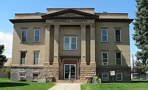 Morrill County Courthouse in Bridgeport | |
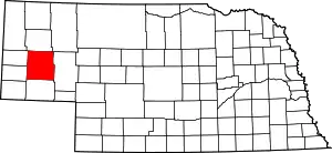 Location within the U.S. state of Nebraska | |
 Nebraska's location within the U.S. | |
| Coordinates: 41°41′N 103°01′W | |
| Country | |
| State | |
| Founded | 1908 |
| Named for | Charles Henry Morrill |
| Seat | Bridgeport |
| Largest city | Bridgeport |
| Area | |
| • Total | 1,430 sq mi (3,700 km2) |
| • Land | 1,424 sq mi (3,690 km2) |
| • Water | 6.0 sq mi (16 km2) 0.4%% |
| Population | |
| • Estimate (2017) | 4,836 |
| • Density | 3.4/sq mi (1.3/km2) |
| Time zone | UTC−7 (Mountain) |
| • Summer (DST) | UTC−6 (MDT) |
| Congressional district | 3rd |
| Website | www |
In the Nebraska license plate system, Morrill County is represented by the prefix 64 (it had the 64th-largest number of vehicles registered in the state when the license plate system was established in 1922).
History
The Battle of Mud Springs and the Battle of Rush Creek between the US Army and Cheyenne, Lakota Sioux, and Arapaho occurred in 1865 within what would become Morrill County.
On 3 November 1908, voters in Cheyenne County passed a measure calling for the division of that county. Accordingly, the Nebraska State Legislature passed an act providing for the division of Cheyenne County, the line of division running east–west, south of the town of Bridgeport. The northern portion so divided was to be called Morrill County. In December of that year, another election determined Bridgeport to be the seat of the new county, and the new county's officials were determined.[3] The county was named for Charles Henry Morrill, a president of the Lincoln Land Company.[4]
Geography
The terrain of Morrill County consists of low rolling hills. A portion of the area is used for agriculture, including some center pivot irrigation. The North Platte River flows east-southeastward through the south-central part of the county, passing Bridgeport before exiting the county some 4 mi (6 km) above the southeast county corner.[5] The county has a total area of 1,430 square miles (3,700 km2), of which 1,424 square miles (3,690 km2) are land and 6.0 square miles (16 km2) (0.4%) are covered by water.[6]
Chimney Rock, a rock formation 325 feet (99 m) tall with a 120-foot (37 m) spire, lies about 4 mi (6 km) south of Bayard, in western Morrill County. The rock was a prominent landmark on the Oregon Trail, and has become a symbol of Nebraska, appearing on the state's license plates and on its commemorative quarter.[7][8][9]
Adjacent counties
- Box Butte County – north
- Sheridan County – northeast
- Garden County – east
- Cheyenne County – south
- Banner County – southwest
- Scotts Bluff County – northwest
Main highways
 US 385 - runs north and south through the county
 US 26 – runs northwest–southeast along the north side of the North Platte River
 Nebraska Highway 92– runs southeast from the western border to its intersection with US 26 near Broadwater
 Nebraska Highway 8 - runs east from a point north of the southwest corner of the county; turns north to its intersection with US 26 near Bridgeport[5]
Demographics
| Historical population | |||
|---|---|---|---|
| Census | Pop. | %± | |
| 1910 | 4,584 | — | |
| 1920 | 9,151 | 99.6% | |
| 1930 | 9,950 | 8.7% | |
| 1940 | 9,436 | −5.2% | |
| 1950 | 8,263 | −12.4% | |
| 1960 | 7,057 | −14.6% | |
| 1970 | 5,813 | −17.6% | |
| 1980 | 6,085 | 4.7% | |
| 1990 | 5,423 | −10.9% | |
| 2000 | 5,440 | 0.3% | |
| 2010 | 5,042 | −7.3% | |
| 2017 (est.) | 4,836 | [10] | −4.1% |
| US Decennial Census[11] 1790-1960[12] 1900-1990[13] 1990-2000[14] 2010-2013[1] | |||
As of the 2000 United States Census,[15] 5,440 people, 2,138 households, and 1,494 families resided in the county. The population density was 4 people per square mile (1/km2). The2,460 housing units averaged 2 per square mile (1/km2). The racial makeup of the county was 93.68% White, 0.07% African American, 0.72% Native American, 0.22% Asian, 4.12% from other races, and 1.19% from two or more races. About 10.09% of the population was Hispanic or Latino of any race. The people were about 40.5% were of 40.5% German, 9.2% English, 7.3% Irish, and 6.7% American ancestry.
Of the 2,138 households, 32.10% had children under the age of 18 living with them, 59.50% were married couples living together, 6.50% had a female householder with no husband present, and 30.10% were not families. About 26.90% of all households were made up of individuals, and 13.00% had someone living alone who was 65 years of age or older. The average household size was 2.49 and the average family size was 3.03.
The county population was distributed as 27.20% under the age of 18, 7.20% from 18 to 24, 24.40% from 25 to 44, 24.20% from 45 to 64, and 17.00% who were 65 years of age or older. The median age was 40 years. For every 100 females, there were 97.90 males. For every 100 females age 18 and over, there were 95.60 males.
The median income for a household in the county was $30,235, and for a family was $36,673. Males had a median income of $27,107 versus $19,271 for females. The per capita income for the county was $14,725. About 10.00% of families and 14.70% of the population were below the poverty line, including 20.00% of those under age 18 and 10.30% of those age 65 or over.
Communities
- Angora
- Atkins
- Bayard
- Bonner
- Bridgeport (county seat)
- Broadwater
- Lynn
- Moomaw Corner
- Northport
- Redington
- Vance
Politics and government
Morrill County is in Nebraska's Nebraska's 3rd congressional district.[16] As of 2017, it was represented in the US House of Representatives by Adrian Smith, a member of the Republican Party.[17] As of 2017, the county was part of the state's 47th legislative district,[18] and was represented in the Nebraska Legislature by Steve Erdman; Erdman is a member of the Republican Party, though the legislature is officially nonpartisan.[19]
As of late 2016, 3314 registered voters were in Morrill County. Of these, 2175, or 65.6%, were Republicans; 591, or 17.8%, were Democrats; 522, or 15.8%, registered no political party; and 26, or 0.8%, were Libertarians.[20]
Morrill County voters are reliably Republican in national politics. In no national election since 1936 has the county selected the Democratic Party candidate (as of 2020).
| Year | Republican | Democratic | Third Parties |
|---|---|---|---|
| 2020 | 82.6% 2,113 | 15.1% 386 | 2.3% 59 |
| 2016 | 81.6% 1,802 | 12.9% 284 | 5.6% 123 |
| 2012 | 76.8% 1,681 | 20.8% 455 | 2.5% 54 |
| 2008 | 73.4% 1,725 | 23.7% 557 | 2.9% 69 |
| 2004 | 76.5% 1,755 | 21.6% 495 | 1.9% 43 |
| 2000 | 74.7% 1,597 | 21.5% 460 | 3.8% 81 |
| 1996 | 58.9% 1,296 | 28.2% 620 | 13.0% 286 |
| 1992 | 46.9% 1,185 | 22.8% 577 | 30.3% 765 |
| 1988 | 66.8% 1,556 | 32.4% 754 | 0.9% 21 |
| 1984 | 79.8% 1,888 | 19.6% 464 | 0.6% 14 |
| 1980 | 74.5% 1,893 | 20.2% 512 | 5.3% 135 |
| 1976 | 56.8% 1,351 | 40.8% 971 | 2.4% 57 |
| 1972 | 77.0% 1,740 | 23.0% 520 | |
| 1968 | 66.5% 1,516 | 21.0% 480 | 12.5% 285 |
| 1964 | 57.3% 1,649 | 42.7% 1,228 | |
| 1960 | 62.8% 2,020 | 37.3% 1,199 | |
| 1956 | 63.8% 1,810 | 36.3% 1,029 | |
| 1952 | 73.5% 2,485 | 26.5% 897 | |
| 1948 | 52.8% 1,478 | 47.2% 1,320 | |
| 1944 | 64.3% 1,998 | 35.7% 1,108 | |
| 1940 | 60.1% 2,214 | 39.9% 1,471 | |
| 1936 | 39.8% 1,354 | 58.7% 1,999 | 1.5% 51 |
| 1932 | 40.5% 1,406 | 57.8% 2,008 | 1.8% 62 |
| 1928 | 74.3% 2,318 | 24.5% 765 | 1.2% 38 |
| 1924 | 45.8% 1,153 | 29.1% 734 | 25.1% 632 |
| 1920 | 65.5% 1,366 | 32.0% 667 | 2.5% 52 |
| 1916 | 32.9% 470 | 62.2% 888 | 4.9% 70 |
| 1912 | 20.3% 227 | 35.0% 391 | 44.7% 500 |
See also
References
- "State & County QuickFacts". US Census Bureau. Archived from the original on June 7, 2011. Retrieved September 21, 2013.
- "Find a County". National Association of Counties. Retrieved June 7, 2011.
- County History (accessed 25 January 2019)
- "Archived copy". Archived from the original on 16 July 2011. Retrieved 25 March 2010.CS1 maint: archived copy as title (link) Retrieved on March 15, 2008.
- Morrill County NE Google Maps (accessed 25 January 2019)
- "2010 Census Gazetteer Files". United States Census Bureau. August 22, 2012. Archived from the original on November 13, 2013. Retrieved December 9, 2014.
- Bauer, Scott. "Nebraska's Popular Chimney Rock Eroding". Washington Post. July 15, 2006. Retrieved December 8, 2017.
- "Chimney Rock site of Sunday Afternoon at the Rock series". Scottsbluff Star-Herald. February 7, 2017. Retrieved December 8, 2017.
- "Chimney Rock National Historic Site". City of Bayard. Retrieved December 8, 2017.
- "Population and Housing Unit Estimates". Retrieved 21 January 2019.
- "US Decennial Census". US Census Bureau. Retrieved December 9, 2014.
- "Historical Census Browser". University of Virginia Library. Retrieved December 9, 2014.
- "Population of Counties by Decennial Census: 1900 to 1990". US Census Bureau. Retrieved December 9, 2014.
- "Census 2000 PHC-T-4. Ranking Tables for Counties: 1990 and 2000" (PDF). US Census Bureau. Retrieved December 9, 2014.
- "U.S. Census website". US Census Bureau. Retrieved 31 January 2008.
- "Congress—Maps Clearinghouse". Nebraska Legislature. Retrieved December 8, 2017.
- "Adrian Smith". House Republicans. Retrieved December 8, 2017.
- "Legislature—Maps Clearinghouse. Nebraska Legislature. Retrieved December 8, 2017.
- 2016–17 Nebraska Blue Book, p. 314 for Erdman, p. 276 for nonpartisan Legislature. Retrieved December 8, 2017.
- "Count of Registrants Eligible to Vote". Nebraska Secretary of State. Retrieved December 8, 2017.
- Election Results
Places adjacent to Morrill County, Nebraska | ||||||||||
|---|---|---|---|---|---|---|---|---|---|---|
| ||||||||||
Municipalities and communities of Morrill County, Nebraska, United States | ||
|---|---|---|
| Cities | Map of Nebraska highlighting Morrill County | |
| Village | ||
| Unincorporated communities | ||
| ||

| Authority control |
|---|