Box Butte County, Nebraska
Box Butte County is a county in the U.S. state of Nebraska. As of the 2010 United States Census, the population was 11,308.[1] Its county seat is Alliance.[2] The county was formed in 1886; it took its name from a large box-shaped butte north of Alliance.
Box Butte County | |
|---|---|
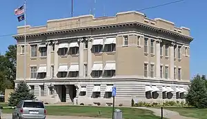 Box Butte County Courthouse in Alliance | |
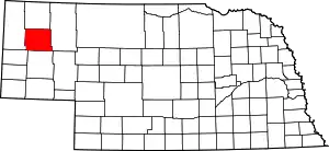 Location within the U.S. state of Nebraska | |
 Nebraska's location within the U.S. | |
| Coordinates: 42°13′N 103°05′W | |
| Country | |
| State | |
| Founded | 1886 |
| Seat | Alliance |
| Largest city | Alliance |
| Area | |
| • Total | 1,078 sq mi (2,790 km2) |
| • Land | 1,075 sq mi (2,780 km2) |
| • Water | 2.5 sq mi (6 km2) 0.2%% |
| Population | |
| • Estimate (2018) | 10,772 |
| • Density | 10.1/sq mi (3.9/km2) |
| Time zone | UTC−7 (Mountain) |
| • Summer (DST) | UTC−6 (MDT) |
| Congressional district | 3rd |
| Website | boxbuttecounty |
In the Nebraska license plate system, Box Butte County is represented by the prefix 65 (it had the sixty-fifth largest number of vehicles registered in the county when the license plate system was established in 1922).
History
Box Butte County was formed as part of a series of partitionings of the Nebraska Panhandle. In 1883, the Nebraska legislature divided the Panhandle into two counties, Sioux and Cheyenne. In 1885 the original Sioux County was divided into three counties: Sioux, Dawes, and Sheridan. Because of the distance to the county seat of Chadron, residents of southern Dawes County asked that it be split off; in 1886, the legislature created Box Butte County. The new county was named after a butte in the northern part of the county; prior to the county's formation, its name had been used in advertisements by railroad companies seeking to entice settlers to the area.[3][4]
In the Nebraska license plate system, Box Butte County is represented by the prefix 65 (it had the 65th-largest number of vehicles registered in the county when the license plate system was established in 1922).
Geography
According to the US Census Bureau, the county has an area of 1,078 square miles (2,790 km2), of which 1,075 square miles (2,780 km2) is land and 2.5 square miles (6.5 km2) (11%) is water.[5]
Major highways
Adjacent counties
- Dawes County - north
- Sheridan County - east
- Morrill County - south
- Scotts Bluff County - southwest
- Sioux County - west
Demographics
| Historical population | |||
|---|---|---|---|
| Census | Pop. | %± | |
| 1890 | 5,494 | — | |
| 1900 | 5,572 | 1.4% | |
| 1910 | 6,131 | 10.0% | |
| 1920 | 8,407 | 37.1% | |
| 1930 | 11,861 | 41.1% | |
| 1940 | 10,736 | −9.5% | |
| 1950 | 12,279 | 14.4% | |
| 1960 | 11,688 | −4.8% | |
| 1970 | 10,094 | −13.6% | |
| 1980 | 13,696 | 35.7% | |
| 1990 | 13,130 | −4.1% | |
| 2000 | 12,158 | −7.4% | |
| 2010 | 11,308 | −7.0% | |
| 2018 (est.) | 10,772 | [6] | −4.7% |
| US Decennial Census[7] 1790-1960[8] 1900-1990[9] 1990-2000[10] 2010-2013[1] | |||
As of the 2000 United States Census,[11] there were 12,158 people, 4,780 households, and 3,298 families in the county. The population density was 11 people per square mile (4/km2). There were 5,488 housing units at an average density of 5 per square ;mile (2/km2). The racial makeup of the county was 90.84% White, 0.37% Black or African American, 2.74% Native American, 0.53% Asian, 0.01% Pacific Islander, 3.55% from other races, and 1.96% from two or more races. 7.65% of the population were Hispanic or Latino of any race. 36.4% were of German, 8.4% English, 8.1% Irish and 5.3% American ancestry.
There were 4,780 households, out of which 35.60% had children under the age of 18 living with them, 57.70% were married couples living together, 8.30% had a female householder with no husband present, and 31.00% were non-families. 27.50% of all households were made up of individuals, and 11.10% had someone living alone who was 65 years of age or older. The average household size was 2.50 and the average family size was 3.05.
The county population contained 28.10% under the age of 18, 7.40% from 18 to 24, 26.80% from 25 to 44, 23.10% from 45 to 64, and 14.60% who were 65 years of age or older. The median age was 38 years. For every 100 females there were 99.20 males. For every 100 females age 18 and over, there were 94.60 males.
The median income for a household in the county was $39,366, and the median income for a family was $46,670. Males had a median income of $36,966 versus $21,762 for females. The per capita income for the county was $18,407. About 9.70% of families and 10.70% of the population were below the poverty line, including 13.70% of those under age 18 and 11.00% of those age 65 or over.
Politics
Box Butte County voters have been reliably Republican for decades; since 1940, the county has selected the Republican Party presidential candidate in every national election (as of 2020).
| Year | Republican | Democratic | Third Parties |
|---|---|---|---|
| 2020 | 77.0% 4,002 | 20.2% 1,051 | 2.8% 147 |
| 2016 | 73.5% 3,617 | 19.6% 965 | 7.0% 342 |
| 2012 | 61.0% 2,869 | 36.0% 1,692 | 3.1% 144 |
| 2008 | 58.9% 2,932 | 37.9% 1,886 | 3.2% 161 |
| 2004 | 65.9% 3,396 | 32.2% 1,657 | 1.9% 99 |
| 2000 | 63.0% 3,208 | 31.7% 1,614 | 5.3% 267 |
| 1996 | 49.4% 2,458 | 35.8% 1,782 | 14.8% 735 |
| 1992 | 38.7% 2,203 | 34.2% 1,942 | 27.1% 1,542 |
| 1988 | 56.4% 3,253 | 42.8% 2,468 | 0.8% 45 |
| 1984 | 72.6% 4,011 | 26.6% 1,471 | 0.8% 43 |
| 1980 | 70.7% 3,912 | 21.8% 1,208 | 7.5% 412 |
| 1976 | 64.6% 2,956 | 33.1% 1,516 | 2.3% 107 |
| 1972 | 78.1% 3,431 | 21.9% 960 | |
| 1968 | 67.5% 2,728 | 26.0% 1,052 | 6.5% 263 |
| 1964 | 58.1% 2,725 | 41.9% 1,968 | |
| 1960 | 62.6% 3,157 | 37.4% 1,886 | |
| 1956 | 68.7% 2,991 | 31.3% 1,362 | |
| 1952 | 78.1% 4,426 | 21.9% 1,239 | |
| 1948 | 53.8% 2,351 | 46.3% 2,023 | |
| 1944 | 63.3% 2,994 | 36.7% 1,736 | |
| 1940 | 57.3% 2,942 | 42.7% 2,195 | |
| 1936 | 36.7% 1,711 | 62.2% 2,900 | 1.1% 52 |
| 1932 | 39.2% 1,772 | 59.4% 2,688 | 1.4% 65 |
| 1928 | 70.7% 3,028 | 28.9% 1,238 | 0.4% 16 |
| 1924 | 42.5% 1,506 | 23.0% 814 | 34.6% 1,225 |
| 1920 | 65.1% 1,630 | 30.2% 756 | 4.7% 117 |
| 1916 | 37.6% 591 | 58.2% 914 | 4.1% 65 |
| 1912 | 17.7% 227 | 40.3% 518 | 42.0% 539[13] |
| 1908 | 45.1% 600 | 51.4% 684 | 3.6% 48 |
| 1904 | 66.7% 668 | 21.7% 217 | 11.6% 116 |
| 1900 | 57.4% 707 | 40.1% 494 | 2.4% 30 |
Notes
- "State & County QuickFacts". US Census Bureau. Archived from the original on July 7, 2011. Retrieved September 17, 2013.
- "Find a County". National Association of Counties. Archived from the original on May 31, 2011. Retrieved June 7, 2011.
- Kooiman and Butterfield (1996), p. 24.
- Fitzpatrick, Lilian Linder (1925). Nebraska Place-Names, p. 20. Retrieved December 11, 2017.
- "2010 Census Gazetteer Files". US Census Bureau. August 22, 2012. Archived from the original on November 13, 2013. Retrieved December 6, 2014.
- "Population and Housing Unit Estimates". Retrieved December 26, 2019.
- "US Decennial Census". US Census Bureau. Retrieved December 6, 2014.
- "Historical Census Browser". University of Virginia Library. Retrieved December 6, 2014.
- "Population of Counties by Decennial Census: 1900 to 1990". US Census Bureau. Retrieved December 6, 2014.
- "Census 2000 PHC-T-4. Ranking Tables for Counties: 1990 and 2000" (PDF). US Census Bureau. Retrieved December 6, 2014.
- "U.S. Census website". US Census Bureau. Retrieved January 31, 2008.
- Election Results
- The leading "other" candidate, Progressive Theodore Roosevelt, received 423 votes, while Socialist candidate Eugene Debs received 97 votes and Write-in candidate Eugene Chafin received 19 votes.
References
Kooiman, Barbara A., and Elizabeth A. Butterfield (1996). "Nebraska Historic Buildings Survey: Reconnaissance Survey Final Report of Box Butte County, Nebraska". Nebraska State Historical Society. Retrieved December 11, 2017.
External links
Places adjacent to Box Butte County, Nebraska | ||||||||||
|---|---|---|---|---|---|---|---|---|---|---|
| ||||||||||
Municipalities and communities of Box Butte County, Nebraska, United States | ||
|---|---|---|
| City | Map of Nebraska highlighting Box Butte County | |
| Village | ||
| CDP | ||
| Unincorporated communities | ||
| ||

| Authority control |
|---|