Jefferson County, Iowa
Jefferson County is a county located in the U.S. state of Iowa. As of the 2010 census, the population was 16,843.[1] The county seat is Fairfield.[2] The county was formed in January 1839, and was named after President Thomas Jefferson.[3][4]
Jefferson County | |
|---|---|
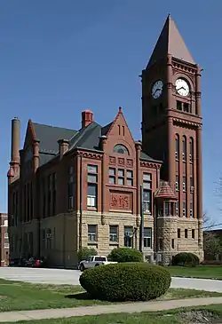 Courthouse in Fairfield is on the NRHP | |
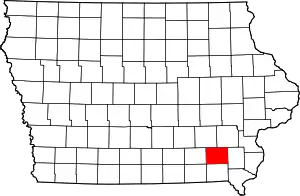 Location within the U.S. state of Iowa | |
 Iowa's location within the U.S. | |
| Coordinates: 41°01′53″N 91°56′41″W | |
| Country | |
| State | |
| Founded | January 21, 1839 |
| Named for | Thomas Jefferson |
| Seat | Fairfield |
| Largest city | Fairfield |
| Area | |
| • Total | 437 sq mi (1,130 km2) |
| • Land | 436 sq mi (1,130 km2) |
| • Water | 1.4 sq mi (4 km2) 0.3% |
| Population (2010) | |
| • Total | 16,843 |
| • Estimate (2018) | 18,381 |
| • Density | 39/sq mi (15/km2) |
| Time zone | UTC−6 (Central) |
| • Summer (DST) | UTC−5 (CDT) |
| Congressional district | 2nd |
| Website | http://www.jeffersoncountyiowa.com |
Jefferson County comprises the Fairfield, IA Micropolitan Statistical Area.
Geography
According to the U.S. Census Bureau, the county has a total area of 437 square miles (1,130 km2), of which 436 square miles (1,130 km2) is land and 1.4 square miles (3.6 km2) (0.3%) is water.[5]
Major highways
Adjacent counties
- Keokuk County (northwest)
- Washington County (northeast)
- Henry County (east)
- Van Buren County (south)
- Wapello County (west)
Demographics
| Historical population | |||
|---|---|---|---|
| Census | Pop. | %± | |
| 1850 | 9,904 | — | |
| 1860 | 15,038 | 51.8% | |
| 1870 | 17,839 | 18.6% | |
| 1880 | 17,469 | −2.1% | |
| 1890 | 15,184 | −13.1% | |
| 1900 | 17,437 | 14.8% | |
| 1910 | 15,951 | −8.5% | |
| 1920 | 16,440 | 3.1% | |
| 1930 | 16,241 | −1.2% | |
| 1940 | 15,762 | −2.9% | |
| 1950 | 15,696 | −0.4% | |
| 1960 | 15,818 | 0.8% | |
| 1970 | 15,774 | −0.3% | |
| 1980 | 16,316 | 3.4% | |
| 1990 | 16,310 | 0.0% | |
| 2000 | 16,181 | −0.8% | |
| 2010 | 16,843 | 4.1% | |
| 2018 (est.) | 18,381 | [6] | 9.1% |
| U.S. Decennial Census[7] 1790-1960[8] 1900-1990[9] 1990-2000[10] 2010-2018[1] | |||
2010 census
The 2010 census recorded a population of 16,843 in the county, with a population density of 38.6893/sq mi (14.9380/km2). There were 7,594 housing units, of which 6,846 were occupied.[11]
2000 census
As of the census[12] of 2000, there were 16,181 people, 6,649 households, and 4,281 families residing in the county. The population density was 37 people per square mile (14/km2). There were 7,241 housing units at an average density of 17 per square mile (6/km2). The racial makeup of the county was 96.02% White, 0.64% Black or African American, 0.17% Native American, 1.70% Asian, 0.04% Pacific Islander, 0.53% from other races, and 0.91% from two or more races. 1.84% of the population were Hispanic or Latino of any race.
There were 6,649 households, out of which 31.10% had children under the age of 18 living with them, 53.10% were married couples living together, 8.00% had a female householder with no husband present, and 35.60% were non-families. 30.40% of all households were made up of individuals, and 10.70% had someone living alone who was 65 years of age or older. The average household size was 2.34 and the average family size was 2.93.
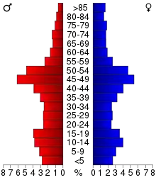
In the county, the population was spread out, with 24.40% under the age of 18, 7.60% from 18 to 24, 24.40% from 25 to 44, 29.80% from 45 to 64, and 13.80% who were 65 years of age or older. The median age was 41 years. For every 100 females, there were 95.90 males. For every 100 females age 18 and over, there were 93.60 males.
The median income for a household in the county was $33,851, and the median income for a family was $43,819. Males had a median income of $32,066 versus $22,479 for females. The per capita income for the county was $19,579. About 7.40% of families and 10.90% of the population were below the poverty line, including 12.40% of those under age 18 and 9.00% of those age 65 or over.
Law and government
Jefferson County's executive branch is a three-member board of supervisors who are elected to four-year terms. The current board members, their party affiliations and the years in which they were last elected are: Steve Burgmeier (Chair) (Republican, 2008), Lee Dimmitt (Republican, 2008), and Richard Reed (Republican, 2010). Other elected officials are Scott Reneker, county auditor; Gregg Morton, county sheriff; Terri Kness, county treasurer; and Kelly Spees, county recorder.[15]
Politics
Historically, Jefferson County heavily favored presidential candidates from the Republican Party. It is noted for being one of the few counties in Iowa that never voted for Woodrow Wilson, along with having never given a Democrat who carried the county over sixty percent of the vote. In recent decades, politics within the county have become more competitive. From 1992 to 2012, the county has been carried by the Democratic presidential candidate in every election with the exception of 2000, when George W. Bush obtained a plurality. The last Republican to win the county with a majority of the vote was Ronald Reagan in 1984. In the 1996 presidential election, Jefferson County was the only county in the United States to give any (winning) candidate less than forty percent of the vote, with Bill Clinton winning the county 35.1% to Bob Dole's 34.4%. In 2016, Donald Trump received a plurality of the votes in Jefferson County. The county has been the strongest basis of support for the Natural Law Party's presidential campaigns, due to the presence of the Maharishi Vedic City. In 2020, the presidential candidate Kanye West got his best result in this county.
| Year | Republican | Democratic | Third Parties |
|---|---|---|---|
| 2020 | 49.6% 4,443 | 48.2% 4,319 | 2.2% 197 |
| 2016 | 46.0% 3,748 | 45.5% 3,710 | 8.6% 698 |
| 2012 | 40.3% 3,436 | 56.3% 4,798 | 3.5% 296 |
| 2008 | 38.5% 3,324 | 58.7% 5,070 | 2.8% 238 |
| 2004 | 44.1% 3,648 | 54.2% 4,490 | 1.7% 143 |
| 2000 | 43.0% 3,248 | 37.9% 2,863 | 19.0% 1,437 |
| 1996 | 34.4% 2,541 | 35.1% 2,597 | 30.5% 2,259 |
| 1992 | 30.5% 2,541 | 30.7% 2,562 | 38.8% 3,238[lower-alpha 1] |
| 1988 | 49.5% 3,614 | 49.3% 3,594 | 1.2% 88 |
| 1984 | 61.2% 4,727 | 38.3% 2,961 | 0.5% 37 |
| 1980 | 56.2% 4,099 | 35.3% 2,577 | 8.5% 623 |
| 1976 | 51.7% 3,746 | 46.6% 3,377 | 1.7% 121 |
| 1972 | 64.8% 4,628 | 33.1% 2,362 | 2.1% 149 |
| 1968 | 59.5% 4,130 | 34.8% 2,411 | 5.7% 398 |
| 1964 | 39.8% 2,755 | 59.8% 4,135 | 0.4% 26 |
| 1960 | 64.0% 4,942 | 36.0% 2,780 | 0.0% 0 |
| 1956 | 62.8% 4,807 | 37.2% 2,845 | 0.1% 7 |
| 1952 | 69.1% 5,630 | 30.3% 2,470 | 0.6% 49 |
| 1948 | 55.1% 3,906 | 42.8% 3,033 | 2.1% 149 |
| 1944 | 59.0% 4,335 | 39.8% 2,926 | 1.1% 83 |
| 1940 | 58.7% 4,891 | 40.8% 3,402 | 0.5% 43 |
| 1936 | 50.8% 4,037 | 46.5% 3,690 | 2.7% 214 |
| 1932 | 41.6% 2,955 | 57.1% 4,056 | 1.4% 99 |
| 1928 | 69.1% 4,919 | 30.3% 2,159 | 0.7% 46 |
| 1924 | 61.6% 4,062 | 18.9% 1,249 | 19.5% 1,282 |
| 1920 | 74.6% 4,558 | 23.7% 1,450 | 1.6% 100 |
| 1916 | 54.6% 2,167 | 43.7% 1,734 | 1.7% 67 |
| 1912 | 37.6% 1,378 | 35.8% 1,311 | 26.6% 973 |
| 1908 | 58.3% 2,271 | 36.9% 1,439 | 4.8% 186 |
| 1904 | 62.2% 2,330 | 31.3% 1,172 | 6.5% 242 |
| 1900 | 58.7% 2,482 | 38.1% 1,612 | 3.1% 132 |
| 1896 | 57.2% 2,478 | 40.9% 1,772 | 1.8% 79 |
Communities
Cities
Townships
Population ranking
The population ranking of the following table is based on the 2010 census of Jefferson County.[17]
† county seat
| Rank | City/Town/etc. | Municipal type | Population (2010 Census) |
|---|---|---|---|
| 1 | † Fairfield | City | 9,464 |
| 2 | Batavia | City | 499 |
| 3 | Libertyville | City | 315 |
| 4 | Lockridge | City | 268 |
| 5 | Maharishi Vedic City | City | 259 |
| 6 | Packwood | City | 204 |
| 7 | Pleasant Plain | City | 93 |
| 8 | Coppock (mostly in Henry and Washington Counties) | City | 47 |
Notes
- The leading "other" candidate, Natural Law candidate John Hagelin, received 1,899 votes, while Independent Ross Perot received 1,241 votes, Independent candidate Ehlers 35 votes, and 63 votes for the others.
References
- "State & County QuickFacts". United States Census Bureau. Archived from the original on June 7, 2011. Retrieved July 18, 2014.
- "Find a County". National Association of Counties. Archived from the original on May 31, 2011. Retrieved June 7, 2011.
- Gannett, Henry (1905). The Origin of Certain Place Names in the United States. Govt. Print. Off. pp. 168.
- Jefferson County Archived October 10, 2007, at the Wayback Machine
- "US Gazetteer files: 2010, 2000, and 1990". United States Census Bureau. February 12, 2011. Retrieved April 23, 2011.
- "Population and Housing Unit Estimates". Retrieved June 22, 2019.
- "U.S. Decennial Census". United States Census Bureau. Retrieved July 18, 2014.
- "Historical Census Browser". University of Virginia Library. Retrieved July 18, 2014.
- "Population of Counties by Decennial Census: 1900 to 1990". United States Census Bureau. Retrieved July 18, 2014.
- "Census 2000 PHC-T-4. Ranking Tables for Counties: 1990 and 2000" (PDF). United States Census Bureau. Retrieved July 18, 2014.
- "Population & Housing Occupancy Status 2010". United States Census Bureau – American FactFinder. Retrieved May 19, 2011.
- "U.S. Census website". United States Census Bureau. Retrieved January 31, 2008.
- Jefferson County Assessor Office – Fairfield Business Park
- Fairfield Business Park 41°03′50″N 91°58′18″W
- "Jefferson County Home Page". Retrieved January 4, 2012.
- Leip, David. "Dave Leip's Atlas of U.S. Presidential Elections". uselectionatlas.org. Retrieved April 26, 2018.
- "2010 U.S. Census website". United States Census Bureau. Retrieved February 13, 2016.
External links
| Wikimedia Commons has media related to Jefferson County, Iowa. |
Places adjacent to Jefferson County, Iowa | ||||||||||
|---|---|---|---|---|---|---|---|---|---|---|
| ||||||||||
Municipalities and communities of Jefferson County, Iowa, United States | ||
|---|---|---|
| Cities | Map of Iowa highlighting Jefferson County | |
| Townships | ||
| Unincorporated communities | ||
| Footnotes | ‡This populated place also has portions in an adjacent county or counties | |
| ||

| Authority control |
|---|