Montgomery County, Iowa
Montgomery County is a county located in the southwestern area of the U.S. state of Iowa. As of the 2010 census, the population was 10,740.[1] Its population has declined since a peak in 1900, since urbanization and decline of family farms. The county seat is Red Oak.[2] The county was founded by European-American migrants from eastern areas in 1851.[3] It was named in honor of Richard Montgomery, an American Revolutionary War general killed in 1775 while trying to capture Quebec City, Canada.
Montgomery County | |
|---|---|
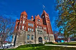
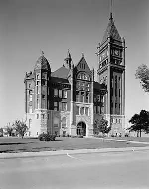 Montgomery County Courthouse | |
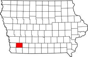 Location within the U.S. state of Iowa | |
 Iowa's location within the U.S. | |
| Coordinates: 41°01′45″N 95°09′05″W | |
| Country | |
| State | |
| Founded | 1851 |
| Named for | Richard Montgomery |
| Seat | Red Oak |
| Largest city | Red Oak |
| Area | |
| • Total | 425 sq mi (1,100 km2) |
| • Land | 424 sq mi (1,100 km2) |
| • Water | 0.9 sq mi (2 km2) 0.2% |
| Population (2010) | |
| • Total | 10,740 |
| • Estimate (2018) | 10,003 |
| • Density | 25/sq mi (9.8/km2) |
| Time zone | UTC−6 (Central) |
| • Summer (DST) | UTC−5 (CDT) |
| Congressional district | 3rd |
| Website | www |
The county has been largely rural and devoted to agriculture. The county was first surveyed in 1852. It is famous as the location of the unsolved Villisca Axe Murders committed in 1912.
Clyde Cessna, the founder of the Cessna Aircraft Company, was born here.
Geography
According to the U.S. Census Bureau, the county has a total area of 425 square miles (1,100 km2), of which 424 square miles (1,100 km2) is land and 0.9 square miles (2.3 km2) (0.2%) is water.[4]
Major highways
 U.S. Route 34
 U.S. Route 71
 Iowa Highway 48
Adjacent counties
- Pottawattamie County (northwest)
- Cass County (northeast)
- Adams County (east)
- Page County (south)
- Mills County (west)
Demographics
| Historical population | |||
|---|---|---|---|
| Census | Pop. | %± | |
| 1860 | 1,256 | — | |
| 1870 | 5,934 | 372.5% | |
| 1880 | 15,895 | 167.9% | |
| 1890 | 15,848 | −0.3% | |
| 1900 | 17,803 | 12.3% | |
| 1910 | 16,604 | −6.7% | |
| 1920 | 17,048 | 2.7% | |
| 1930 | 16,752 | −1.7% | |
| 1940 | 15,697 | −6.3% | |
| 1950 | 15,685 | −0.1% | |
| 1960 | 14,467 | −7.8% | |
| 1970 | 12,781 | −11.7% | |
| 1980 | 13,413 | 4.9% | |
| 1990 | 12,076 | −10.0% | |
| 2000 | 11,771 | −2.5% | |
| 2010 | 10,740 | −8.8% | |
| 2018 (est.) | 10,003 | [5] | −6.9% |
| U.S. Decennial Census[6] 1790-1960[7] 1900-1990[8] 1990-2000[9] 2010-2018[1] | |||
2010 census
The 2010 census recorded a population of 10,740 in the county, with a population density of 25.337/sq mi (9.783/km2). There were 5,239 housing units, of which 4,558 were occupied.[10]
2000 census
At the 2000 census there were 11,771 people, 4,886 households, and 3,258 families in the county. The population density was 28 people per square mile (11/km2). There were 5,399 housing units at an average density of 13 per square mile (5/km2). The racial makeup of the county was 98.20% White, 0.08% Black or African American, 0.35% Native American, 0.25% Asian, 0.01% Pacific Islander, 0.68% from other races, and 0.44% from two or more races. 1.30%.[11] were Hispanic or Latino of any race.
Of the 4,886 households 29.70% had children under the age of 18 living with them, 54.40% were married couples living together, 8.70% had a female householder with no husband present, and 33.30% were non-families. 29.50% of households were one person and 14.70% were one person aged 65 or older. The average household size was 2.36 and the average family size was 2.91.
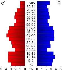
The age distribution was 25.00% under the age of 18, 6.50% from 18 to 24, 25.50% from 25 to 44, 22.80% from 45 to 64, and 20.30% 65 or older. The median age was 40 years. For every 100 females there were 90.20 males. For every 100 females age 18 and over, there were 87.30 males.
The median household income was $33,214 and the median family income was $40,129. Males had a median income of $28,531 versus $20,835 for females. The per capita income for the county was $16,373. About 6.50% of families and 9.10% of the population were below the poverty line, including 12.30% of those under age 18 and 6.00% of those age 65 or over.
Communities
Unincorporated community
Former towns
- Alix (Douglas Township) 1895-98
- Arlington (Washington Township)
- Biddick (Pilot Grove Township) 1893-1902
- Carr's Point (West Township) 1865-70
- Climax (West Township) 1871-1901
- Coe's Grove 1858-69
- Flora 1859
- Frankfort (County seat from 1864 to 1865) (Frankfort Township) 1856-78
- Hawthorne 1871-1908
- Oro 1856-1858
- Ross Grove (Jackson Township) 1855-63
- Rossville (Jackson Township) 1855
- Sciola (Washington Township) 1855-1905
- Wales (Lincoln Township) 1886-1901
- Wallace (Douglas Township) 1875-78
- Wilson (Pilot Grove Township) 1870-79
Townships
Population ranking
The population ranking of the following table is based on the 2010 census of Montgomery County.[12]
† county seat
| Rank | City/Town/etc. | Municipal type | Population (2010 Census) |
|---|---|---|---|
| 1 | † Red Oak | City | 5,742 |
| 2 | Villisca | City | 1,252 |
| 3 | Stanton | City | 689 |
| 4 | Elliott | City | 350 |
| 5 | Grant | City | 92 |
| 6 | Coburg | City | 42 |
Politics
| Year | Republican | Democratic | Third Parties |
|---|---|---|---|
| 2016 | 68.1% 3,436 | 26.1% 1,314 | 5.8% 294 |
| 2012 | 59.7% 3,001 | 38.3% 1,922 | 2.0% 102 |
| 2008 | 54.6% 2,887 | 44.0% 2,326 | 1.4% 76 |
| 2004 | 64.8% 3,601 | 34.2% 1,899 | 1.0% 56 |
| 2000 | 63.4% 3,417 | 34.1% 1,838 | 2.6% 139 |
| 1996 | 49.7% 2,583 | 36.8% 1,912 | 13.5% 703 |
| 1992 | 44.8% 2,404 | 29.8% 1,599 | 25.5% 1,366 |
| 1988 | 62.1% 3,166 | 37.2% 1,898 | 0.7% 36 |
| 1984 | 71.2% 4,224 | 28.0% 1,661 | 0.8% 45 |
| 1980 | 68.0% 4,115 | 25.7% 1,556 | 6.3% 383 |
| 1976 | 61.5% 3,673 | 37.3% 2,229 | 1.2% 72 |
| 1972 | 72.7% 4,391 | 25.8% 1,559 | 1.5% 91 |
| 1968 | 64.1% 4,155 | 29.2% 1,892 | 6.7% 434 |
| 1964 | 47.0% 3,101 | 52.9% 3,489 | 0.2% 11 |
| 1960 | 65.2% 4,974 | 34.8% 2,655 | 0.0% 1 |
| 1956 | 65.8% 5,027 | 34.0% 2,597 | 0.3% 19 |
| 1952 | 72.9% 6,074 | 26.8% 2,235 | 0.3% 25 |
| 1948 | 59.1% 4,084 | 39.8% 2,751 | 1.1% 75 |
| 1944 | 61.4% 4,165 | 37.9% 2,572 | 0.7% 46 |
| 1940 | 59.0% 4,848 | 40.5% 3,332 | 0.5% 40 |
| 1936 | 52.4% 4,395 | 46.8% 3,920 | 0.8% 67 |
| 1932 | 47.4% 3,507 | 50.8% 3,760 | 1.8% 134 |
| 1928 | 70.8% 5,155 | 28.6% 2,079 | 0.6% 46 |
| 1924 | 64.5% 4,617 | 11.3% 805 | 24.2% 1,735 |
| 1920 | 76.5% 4,980 | 21.6% 1,404 | 1.9% 126 |
| 1916 | 60.3% 2,333 | 37.0% 1,431 | 2.7% 103 |
| 1912 | 23.1% 917 | 30.4% 1,206 | 46.6% 1,851 |
| 1908 | 64.4% 2,553 | 32.4% 1,282 | 3.2% 127 |
| 1904 | 75.3% 2,956 | 18.4% 722 | 6.4% 250 |
| 1900 | 65.3% 2,927 | 32.7% 1,467 | 2.1% 92 |
| 1896 | 63.7% 2,927 | 35.5% 1,634 | 0.8% 36 |
References
- "State & County QuickFacts". United States Census Bureau. Archived from the original on June 7, 2011. Retrieved July 20, 2014.
- "Find a County". National Association of Counties. Retrieved June 7, 2011.
- William Walace Merritt (1906). A History of the County of Montgomery. The Express Publishing Company.
montgomery county iowa founding.
- "US Gazetteer files: 2010, 2000, and 1990". United States Census Bureau. February 12, 2011. Retrieved April 23, 2011.
- "Population and Housing Unit Estimates". Retrieved June 24, 2019.
- "U.S. Decennial Census". United States Census Bureau. Retrieved July 20, 2014.
- "Historical Census Browser". University of Virginia Library. Retrieved July 20, 2014.
- "Population of Counties by Decennial Census: 1900 to 1990". United States Census Bureau. Retrieved July 20, 2014.
- "Census 2000 PHC-T-4. Ranking Tables for Counties: 1990 and 2000" (PDF). United States Census Bureau. Retrieved July 20, 2014.
- "Population & Housing Occupancy Status 2010". United States Census Bureau American FactFinder. Retrieved May 22, 2011.
- "U.S. Census website". United States Census Bureau. Retrieved January 31, 2008.
- https://www.census.gov/2010census/
- Leip, David. "Dave Leip's Atlas of U.S. Presidential Elections". uselectionatlas.org. Retrieved April 27, 2018.
External links
| Wikimedia Commons has media related to Montgomery County, Iowa. |
Places adjacent to Montgomery County, Iowa | ||||||||||
|---|---|---|---|---|---|---|---|---|---|---|
| ||||||||||
Municipalities and communities of Montgomery County, Iowa, United States | ||
|---|---|---|
| Cities | Map of Iowa highlighting Montgomery County | |
| Townships | ||
| Unincorporated communities | ||
| ||

| Authority control |
|---|