Allamakee County, Iowa
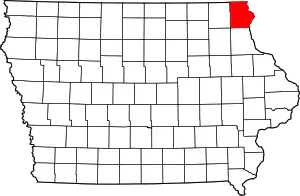
Allamakee County (/ˈæləməˌki/) is the northeasternmost county in the U.S. state of Iowa. As of the 2010 census, the population was 14,330.[1] Its county seat is Waukon.[2]
Allamakee County | |
|---|---|
 | |
 Location within the U.S. state of Iowa | |
 Iowa's location within the U.S. | |
| Coordinates: 43°17′12″N 91°22′27″W | |
| Country | |
| State | |
| Founded | 1847 |
| Seat | Waukon |
| Largest city | Waukon |
| Area | |
| • Total | 659 sq mi (1,710 km2) |
| • Land | 639 sq mi (1,660 km2) |
| • Water | 20 sq mi (50 km2) 3.0% |
| Population (2010) | |
| • Total | 14,330 |
| • Estimate (2018) | 13,832 |
| • Density | 22/sq mi (8.4/km2) |
| Time zone | UTC−6 (Central) |
| • Summer (DST) | UTC−5 (CDT) |
| Congressional district | 1st |
| Website | www |
History
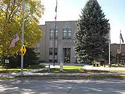
Allamakee County was formed on February 20, 1847. The derivation of the name is debated, some believing it was the name of an Indian chief, others think it was named for Allen Magee, an early historic trader.[3] The first Allamakee County Courthouse in Waukon, built in 1861, now serves as the Allamakee County Historical Museum. The present Allamakee County Court House was built in 1940. Both courthouse buildings are listed on the National Register of Historic Places.[4]
Geography
According to the U.S. Census Bureau, the county has a total area of 659 square miles (1,710 km2), of which 639 square miles (1,660 km2) is land and 20 square miles (52 km2) (3.0%) is water.[5]
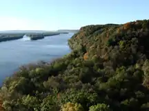
In the northern part of the county is the Upper Iowa River. In the southern part is the Yellow River. The eastern boundary is the Mississippi River. All offer scenic and recreational opportunities, particularly in Yellow River State Forest.
French Creek flows north of Waukon, outside the city limits. Paint Creek, named after Paint Rock Bluff, flows out of the south of Waukon. Norfolk creek originates in the western outskirts of Waukon and is effluent to the Yellow River. Clear Creek flows into Lansing. Village Creek flows through essentially rural terrain. All are tributary to the Mississippi River.
The landforms encountered in the county are very unlike those found in most of Iowa, which is mostly absent Glacial Drift. As part of the Driftless Area, the county was ice free during the last ice age, and as one progresses to the Mississippi River, the streams and rivers display high-walled canyons carved of Silurian period bedrock. This Driftless Area also includes parts of Clayton, Fayette, Winneshiek, Howard, Dubuque, and Jackson Counties.[6]
Major highways
.svg.png.webp) U.S. Highway 18
U.S. Highway 18.svg.png.webp) U.S. Highway 52
U.S. Highway 52 Iowa Highway 9
 Iowa Highway 26
 Iowa Highway 51
 Iowa Highway 76
Adjacent counties
- Houston County, Minnesota (north)
- Vernon County, Wisconsin (northeast)
- Crawford County, Wisconsin (east)
- Clayton County (south)
- Winneshiek County (west)
- Fayette County (southwest)
Demographics
| Historical population | |||
|---|---|---|---|
| Census | Pop. | %± | |
| 1850 | 777 | — | |
| 1860 | 12,237 | 1,474.9% | |
| 1870 | 17,868 | 46.0% | |
| 1880 | 19,791 | 10.8% | |
| 1890 | 17,907 | −9.5% | |
| 1900 | 18,711 | 4.5% | |
| 1910 | 17,328 | −7.4% | |
| 1920 | 17,285 | −0.2% | |
| 1930 | 16,328 | −5.5% | |
| 1940 | 17,184 | 5.2% | |
| 1950 | 16,351 | −4.8% | |
| 1960 | 15,982 | −2.3% | |
| 1970 | 14,968 | −6.3% | |
| 1980 | 15,108 | 0.9% | |
| 1990 | 13,855 | −8.3% | |
| 2000 | 14,675 | 5.9% | |
| 2010 | 14,330 | −2.4% | |
| 2018 (est.) | 13,832 | [7] | −3.5% |
| U.S. Decennial Census[8] 1790-1960[9] 1900-1990[10] 1990-2000[11] 2010-2018[1] | |||
2010 census
The 2010 census recorded a population of 14,330 in the county, with a population density of 22.39/sq mi (8.65/km2). There were 7,617 housing units, of which 5,845 were occupied.[12]
2000 census
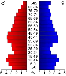
As of the census[13] of 2000, there were 14,675 people, 5,722 households, and 3,931 families residing in the county. The population density was 23 people per square mile (9/km2). There were 7,142 housing units at an average density of 11 per square mile (4/km2). The racial makeup of the county was 95.88% White, 0.14% Black or African American, 0.18% Native American, 0.27% Asian, 0.01% Pacific Islander, 2.82% from other races, and 0.70% from two or more races. 3.54% of the population were Hispanic or Latino of any race.
There were 5,722 households, out of which 30.60% had children under the age of 18 living with them, 58.40% were married couples living together, 6.60% had a female householder with no husband present, and 31.30% were non-families. 27.50% of all households were made up of individuals, and 14.30% had someone living alone who was 65 years of age or older. The average household size was 2.49 and the average family size was 3.02.
In the county, the population was spread out, with 25.40% under the age of 18, 7.00% from 18 to 24, 25.60% from 25 to 44, 23.60% from 45 to 64, and 18.40% who were 65 years of age or older. The median age was 40 years. For every 100 females there were 100.20 males. For every 100 females age 18 and over, there were 98.90 males.
The median income for a household in the county was $33,967, and the median income for a family was $40,589. Males had a median income of $26,122 versus $19,098 for females. The per capita income for the county was $16,599. About 6.40% of families and 9.60% of the population were below the poverty line, including 11.80% of those under age 18 and 8.10% of those age 65 or over.
Notable sites
- Effigy Mounds National Monument is found in the southeast corner of the county.
- Upper Mississippi River National Wildlife and Fish Refuge encompasses the River.
- Driftless Area National Wildlife Refuge, a collection of small, non-contiguous parcels harboring two endangered species.
- Yellow River State Forest is a four-season state park.
Communities
Cities
Townships
Allamakee County is divided into eighteen townships:
Population ranking
The population ranking of the following table is based on the 2010 census of Allamakee County.[14]
† county seat
| Rank | City/Town/etc. | Municipal type | Population (2010 Census) |
|---|---|---|---|
| 1 | † Waukon | City | 3,897 |
| 2 | Postville (mostly in Clayton County) | City | 2,227 |
| 3 | Lansing | City | 999 |
| 4 | New Albin | City | 522 |
| 5 | Harpers Ferry | City | 328 |
| 6 | Waterville | City | 144 |
Politics
| Year | Republican | Democratic | Third Parties |
|---|---|---|---|
| 2020 | 63.8% 4,735 | 34.7% 2,576 | 1.5% 111 |
| 2016 | 59.1% 4,093 | 35.0% 2,421 | 5.9% 409 |
| 2012 | 47.1% 3,264 | 51.2% 3,553 | 1.7% 117 |
| 2008 | 42.0% 2,965 | 56.2% 3,971 | 1.8% 126 |
| 2004 | 50.0% 3,530 | 48.8% 3,449 | 1.2% 83 |
| 2000 | 50.7% 3,277 | 44.6% 2,883 | 4.7% 302 |
| 1996 | 42.5% 2,457 | 44.1% 2,551 | 13.4% 773 |
| 1992 | 39.3% 2,627 | 35.4% 2,362 | 25.3% 1,690 |
| 1988 | 53.1% 3,186 | 46.2% 2,768 | 0.7% 41 |
| 1984 | 62.9% 3,997 | 35.9% 2,282 | 1.2% 75 |
| 1980 | 60.7% 4,000 | 33.0% 2,170 | 6.3% 416 |
| 1976 | 57.9% 3,648 | 40.7% 2,568 | 1.4% 87 |
| 1972 | 63.2% 4,150 | 34.6% 2,271 | 2.2% 141 |
| 1968 | 62.6% 4,449 | 31.6% 2,245 | 5.9% 416 |
| 1964 | 51.3% 3,691 | 48.7% 3,504 | 0.1% 5 |
| 1960 | 62.8% 4,970 | 37.1% 2,933 | 0.2% 13 |
| 1956 | 66.2% 5,182 | 33.5% 2,622 | 0.3% 20 |
| 1952 | 72.1% 6,087 | 27.7% 2,341 | 0.1% 10 |
| 1948 | 57.9% 4,474 | 41.1% 3,172 | 1.0% 80 |
| 1944 | 63.3% 5,017 | 36.5% 2,893 | 0.2% 19 |
| 1940 | 64.0% 5,840 | 35.7% 3,258 | 0.3% 24 |
| 1936 | 46.3% 4,053 | 49.4% 4,327 | 4.4% 383 |
| 1932 | 38.3% 3,009 | 61.0% 4,783 | 0.7% 56 |
| 1928 | 59.4% 4,785 | 40.1% 3,227 | 0.5% 39 |
| 1924 | 38.4% 2,755 | 18.0% 1,289 | 43.6% 3,131 |
| 1920 | 73.2% 5,192 | 25.9% 1,833 | 0.9% 65 |
| 1916 | 58.0% 2,411 | 41.2% 1,714 | 0.8% 34 |
| 1912 | 29.1% 1,269 | 40.5% 1,767 | 30.4% 1,325 |
| 1908 | 58.7% 2,521 | 40.1% 1,725 | 1.2% 51 |
| 1904 | 61.8% 2,609 | 37.2% 1,571 | 1.0% 44 |
| 1900 | 58.4% 2,659 | 40.7% 1,850 | 0.9% 41 |
| 1896 | 55.2% 2,471 | 42.3% 1,897 | 2.5% 112 |
See also
References
- "State & County QuickFacts". United States Census Bureau. Archived from the original on June 7, 2011. Retrieved July 13, 2014.
- "Find a County". National Association of Counties. Archived from the original on May 31, 2011. Retrieved June 7, 2011.
- Alexander, W. E. (1882). History of Winneshiek and Allamakee Counties, Iowa. Western Publishing Company. p. 326.
- "National Register Information System". National Register of Historic Places. National Park Service. March 13, 2009.
- "US Gazetteer files: 2010, 2000, and 1990". United States Census Bureau. February 12, 2011. Retrieved April 23, 2011.
- Iowa DNR site on Yellow River State Forest Archived July 14, 2007, at the Wayback Machine
- "Population and Housing Unit Estimates". Retrieved June 27, 2019.
- "U.S. Decennial Census". United States Census Bureau. Retrieved July 13, 2014.
- "Historical Census Browser". University of Virginia Library. Retrieved July 13, 2014.
- "Population of Counties by Decennial Census: 1900 to 1990". United States Census Bureau. Retrieved July 13, 2014.
- "Census 2000 PHC-T-4. Ranking Tables for Counties: 1990 and 2000" (PDF). United States Census Bureau. Retrieved July 13, 2014.
- "Population and Housing Occupancy Status: 2010 - State -- County". United States Census Bureau American FactFinder. Retrieved March 6, 2011.
- "U.S. Census website". United States Census Bureau. Retrieved January 31, 2008.
- "Archived copy". Retrieved February 13, 2016.
- Leip, David. "Dave Leip's Atlas of U.S. Presidential Elections". uselectionatlas.org. Retrieved April 25, 2018.
External links
| Wikimedia Commons has media related to Allamakee County, Iowa. |
- Allamakee County Information
- Allamakee County Official Site
- Allamakee County Map
- Allamakee County Health and Demographic Data
- Waukon Standard (Newspaper)
- KNEI/KHPP Radio
- Allamakee County History Website
Places adjacent to Allamakee County, Iowa | |
|---|---|
Municipalities and communities of Allamakee County, Iowa, United States | ||
|---|---|---|
| Cities | Map of Iowa highlighting Allamakee County | |
| Townships | ||
| Unincorporated communities | ||
| Footnotes | ‡This populated place also has portions in an adjacent county or counties | |
| ||

| Authority control |
|---|