Cerro Gordo County, Iowa
Cerro Gordo County (/ˈsɛroʊ ˈɡɔːrdoʊ/; Spanish: [ˈsero ˈɣoɾðo]) is a county located in the U.S. state of Iowa. As of the 2010 census, the population was 44,151.[1] Its county seat is Mason City.[2] The county is named for the Battle of Cerro Gordo, which took place during the Mexican–American War.
Cerro Gordo County | |
|---|---|
 | |
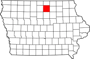 Location within the U.S. state of Iowa | |
 Iowa's location within the U.S. | |
| Coordinates: 43°04′46″N 93°16′01″W | |
| Country | |
| State | |
| Founded | 1851 |
| Named for | Battle of Cerro Gordo |
| Seat | Mason City |
| Largest city | Mason City |
| Area | |
| • Total | 575 sq mi (1,490 km2) |
| • Land | 568 sq mi (1,470 km2) |
| • Water | 6.8 sq mi (18 km2) 1.2% |
| Population (2010) | |
| • Total | 44,151 |
| • Estimate (2018) | 42,647 |
| • Density | 77/sq mi (30/km2) |
| Time zone | UTC−6 (Central) |
| • Summer (DST) | UTC−5 (CDT) |
| Congressional district | 4th |
| Website | www |
Cerro Gordo County is part of the Mason City, IA Micropolitan Statistical Area.
History
Cerro Gordo County was formed in 1851 and takes its name from the Battle of Cerro Gordo in the Mexican–American War, where General Winfield Scott defeated the Mexican General Santa Anna on April 18, 1847.
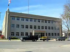
In 1851 the first white settlers came into the area of the present county and settled on Clear Lake. Four years later, on August 7, 1855, the first elections were held and the first legal proceedings occurred in 1857. In the summer of the same year, Livonia was chosen as the new county seat. In 1858, the seat was returned to Mason City. In 1866, the first courthouse was erected, which was used until 1900. The courthouse still used today opened on November 17, 1960.
Cerro Gordo County was the site of the airplane crash north of the city of Clear Lake, in which rock and roll stars Buddy Holly, Ritchie Valens, and J.P. "The Big Bopper" Richardson, along with their pilot Roger A. Peterson, were killed on February 3, 1959. The site is in Grant Township, in the northwestern part of the county.
Geography
According to the U.S. Census Bureau, the county has a total area of 575 square miles (1,490 km2), of which 568 square miles (1,470 km2) is land and 6.8 square miles (18 km2) (1.2%) is water.[3]
Law enforcement
The Cerro Gordo County Sheriff's Office is headed by Sheriff Kevin Pals. The Sheriff's Office provides law enforcement, performs investigations, executes legal processes such as writs, and is responsible for operating the county jail and for inmates in custody.
The Sheriff's Office is at 17262 Lark Ave, Mason City, IA 50401.[4]
Major highways
.svg.png.webp) Interstate 35
Interstate 35.svg.png.webp) U.S. Highway 18
U.S. Highway 18.svg.png.webp) U.S. Highway 65
U.S. Highway 65 Iowa Highway 27
 Iowa Highway 122
Airport
The county also has a municipal airport, Mason City Municipal Airport, (MCW) with commercial service by Air Choice One.
Adjacent counties
- Worth County (north)
- Mitchell County (northeast)
- Floyd County (east)
- Franklin County (south)
- Hancock County (west)
Demographics
| Historical population | |||
|---|---|---|---|
| Census | Pop. | %± | |
| 1860 | 940 | — | |
| 1870 | 4,722 | 402.3% | |
| 1880 | 11,461 | 142.7% | |
| 1890 | 14,864 | 29.7% | |
| 1900 | 20,672 | 39.1% | |
| 1910 | 25,011 | 21.0% | |
| 1920 | 34,675 | 38.6% | |
| 1930 | 38,476 | 11.0% | |
| 1940 | 43,845 | 14.0% | |
| 1950 | 46,053 | 5.0% | |
| 1960 | 49,894 | 8.3% | |
| 1970 | 49,223 | −1.3% | |
| 1980 | 48,458 | −1.6% | |
| 1990 | 46,733 | −3.6% | |
| 2000 | 46,447 | −0.6% | |
| 2010 | 44,151 | −4.9% | |
| 2018 (est.) | 42,647 | [5] | −3.4% |
| U.S. Decennial Census[6] 1790-1960[7] 1900-1990[8] 1990-2000[9] 2010-2018[1] | |||
2010 census
The 2010 census recorded a population of 44,151 in the county, with a population density of 77.73/sq mi (30.012/km2). There were 22,163 housing units, of which 19,350 were occupied.[10]
2000 census
At the 2000 census there were 46,447 people, 19,374 households, and 12,399 families in the county. The population density was 82 people per square mile (32/km2). There were 21,488 housing units at an average density of 38 per square mile (15/km2). The racial makeup of the county was 96.26% White, 0.80% Black or African American, 0.17% Native American, 0.70% Asian, 0.02% Pacific Islander, 0.88% from other races, and 1.16% from two or more races. 2.78%.[11] were Hispanic or Latino of any race.
Of the 19,374 households 29.10% had children under the age of 18 living with them, 51.90% were married couples living together, 9.10% had a female householder with no husband present, and 36.00% were non-families. 30.90% of households were one person and 13.50% were one person aged 65 or older. The average household size was 2.32 and the average family size was 2.91.
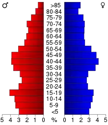
The age distribution was 23.80% under the age of 18, 9.00% from 18 to 24, 26.40% from 25 to 44, 23.20% from 45 to 64, and 17.70% 65 or older. The median age was 39 years. For every 100 females, there were 92.80 males. For every 100 females age 18 and over, there were 89.10 males.
The median household income was $35,867 and the median family income was $46,099. Males had a median income of $31,790 versus $21,781 for females. The per capita income for the county was $19,184. About 5.90% of families and 8.50% of the population were below the poverty line, including 9.10% of those under age 18 and 8.60% of those age 65 or over.
Communities
Cities
Townships
Cerro Gordo County is divided into sixteen townships:
Other unincorporated communities
- Cameron
- Cartersville
- Emery
- Freeman
- Hurley
Population ranking
The population ranking of the following table is based on the 2010 census of Cerro Gordo County.[12]
† county seat
| Rank | City/Town/etc. | Municipal type | Population (2010 Census) |
|---|---|---|---|
| 1 | † Mason City | City | 28,079 |
| 2 | Clear Lake | City | 7,777 |
| 3 | Nora Springs (mostly in Floyd County) | City | 1,431 |
| 4 | Rockwell | City | 1,039 |
| 5 | Ventura | City | 717 |
| 6 | Thornton | City | 422 |
| 7 | Plymouth | City | 382 |
| 8 | Meservey | City | 256 |
| 9 | Swaledale | City | 165 |
| 10 | Rock Falls | City | 155 |
| 11 | Dougherty | City | 58 |
| 12 | Burchinal | CDP | 40 |
| 13 | Portland | CDP | 35 |
Economy
In September 2016 Cerro Gordo County supervisors voted to appeal the Iowa Department of Natural Resources's decision to approve construction of a hog confinement facility near Ventura, Iowa.[13]
Politics
| Year | Republican | Democratic | Third Parties |
|---|---|---|---|
| 2020 | 52.3% 12,442 | 46.0% 10,941 | 1.8% 418 |
| 2016 | 50.6% 11,621 | 42.9% 9,862 | 6.5% 1,482 |
| 2012 | 42.5% 10,128 | 55.9% 13,316 | 1.6% 380 |
| 2008 | 38.8% 9,375 | 59.7% 14,405 | 1.5% 363 |
| 2004 | 44.7% 10,960 | 54.5% 13,372 | 0.8% 184 |
| 2000 | 42.4% 9,397 | 55.0% 12,185 | 2.6% 580 |
| 1996 | 35.0% 7,427 | 56.3% 11,943 | 8.8% 1,857 |
| 1992 | 34.0% 8,250 | 47.0% 11,415 | 19.1% 4,628 |
| 1988 | 41.8% 9,358 | 57.5% 12,857 | 0.7% 150 |
| 1984 | 48.9% 11,214 | 50.4% 11,570 | 0.7% 166 |
| 1980 | 49.0% 11,189 | 41.0% 9,363 | 10.0% 2,276 |
| 1976 | 47.8% 10,604 | 50.4% 11,189 | 1.8% 403 |
| 1972 | 54.7% 11,856 | 43.6% 9,460 | 1.7% 377 |
| 1968 | 52.5% 10,661 | 42.1% 8,554 | 5.4% 1,095 |
| 1964 | 37.4% 7,884 | 62.4% 13,156 | 0.2% 31 |
| 1960 | 56.1% 12,830 | 43.9% 10,044 | 0.1% 15 |
| 1956 | 57.0% 12,449 | 42.9% 9,362 | 0.1% 30 |
| 1952 | 61.1% 13,207 | 38.7% 8,354 | 0.2% 47 |
| 1948 | 44.3% 7,840 | 54.0% 9,544 | 1.7% 298 |
| 1944 | 47.6% 8,311 | 52.1% 9,088 | 0.3% 60 |
| 1940 | 47.2% 9,728 | 52.6% 10,839 | 0.2% 45 |
| 1936 | 42.7% 7,599 | 54.5% 9,694 | 2.8% 501 |
| 1932 | 45.1% 7,317 | 54.0% 8,752 | 0.9% 149 |
| 1928 | 65.8% 9,582 | 33.7% 4,908 | 0.5% 77 |
| 1924 | 58.9% 8,410 | 9.4% 1,345 | 31.7% 4,536 |
| 1920 | 75.7% 8,293 | 21.0% 2,302 | 3.3% 356 |
| 1916 | 59.3% 3,556 | 38.2% 2,289 | 2.6% 154 |
| 1912 | 25.6% 1,334 | 33.5% 1,742 | 40.9% 2,126 |
| 1908 | 64.1% 2,990 | 32.6% 1,520 | 3.4% 158 |
| 1904 | 74.6% 3,108 | 20.1% 836 | 5.4% 225 |
| 1900 | 69.5% 3,345 | 27.4% 1,320 | 3.0% 146 |
| 1896 | 66.7% 3,048 | 30.8% 1,408 | 2.5% 112 |
References
- "State & County QuickFacts". United States Census Bureau. Archived from the original on July 8, 2011. Retrieved July 14, 2014.
- "Find a County". National Association of Counties. Archived from the original on May 31, 2011. Retrieved June 7, 2011.
- "US Gazetteer files: 2010, 2000, and 1990". United States Census Bureau. February 12, 2011. Retrieved April 23, 2011.
- "Cerro Gordo County Sheriff". Cerro Gordo County, Iowa. Retrieved November 17, 2016.
- "Population and Housing Unit Estimates". Retrieved June 19, 2019.
- "U.S. Decennial Census". United States Census Bureau. Retrieved July 14, 2014.
- "Historical Census Browser". University of Virginia Library. Retrieved July 14, 2014.
- "Population of Counties by Decennial Census: 1900 to 1990". United States Census Bureau. Retrieved July 14, 2014.
- "Census 2000 PHC-T-4. Ranking Tables for Counties: 1990 and 2000" (PDF). United States Census Bureau. Retrieved July 14, 2014.
- "Population and Housing Occupancy Status: 2010 - State -- County". United States Census Bureau American FactFinder. Retrieved March 8, 2011.
- "U.S. Census website". United States Census Bureau. Retrieved January 31, 2008.
- "Archived copy". Retrieved February 10, 2013.
- JOHN SKIPPER (September 6, 2016). "Supervisors appeal DNR decision to approve hog confinement facility". Mason City: Globe Gazette. Retrieved February 7, 2017.
- Leip, David. "Dave Leip's Atlas of U.S. Presidential Elections". uselectionatlas.org. Retrieved April 25, 2018.
External links
| Wikimedia Commons has media related to Cerro Gordo County, Iowa. |
Places adjacent to Cerro Gordo County, Iowa | ||||||||||
|---|---|---|---|---|---|---|---|---|---|---|
| ||||||||||
Municipalities and communities of Cerro Gordo County, Iowa, United States | ||
|---|---|---|
| Cities | Map of Iowa highlighting Cerro Gordo County | |
| Townships | ||
| CDPs | ||
| Unincorporated communities | ||
| Footnotes | ‡This populated place also has portions in an adjacent county or counties | |
| ||

| Authority control |
|---|