Hardin County, Iowa
Hardin County is a county located in the U.S. state of Iowa. As of the 2010 census, the population was 17,534.[1] The county seat is Eldora.[2] The county was named in honor of Col. John J. Hardin, of Illinois, who was killed in the Mexican–American War.
Hardin County | |
|---|---|
 | |
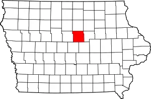 Location within the U.S. state of Iowa | |
 Iowa's location within the U.S. | |
| Coordinates: 42°22′26″N 93°14′41″W | |
| Country | |
| State | |
| Founded | 1851 |
| Named for | John J. Hardin |
| Seat | Eldora |
| Largest city | Iowa Falls |
| Area | |
| • Total | 570 sq mi (1,500 km2) |
| • Land | 569 sq mi (1,470 km2) |
| • Water | 0.7 sq mi (2 km2) 0.1% |
| Population (2010) | |
| • Total | 17,534 |
| • Estimate (2018) | 16,868 |
| • Density | 31/sq mi (12/km2) |
| Time zone | UTC−6 (Central) |
| • Summer (DST) | UTC−5 (CDT) |
| Congressional district | 4th |
| Website | www |
History
Hardin County was formed in 1851. It was named after Colonel John J. Hardin, who died in the Mexican–American War.[3]
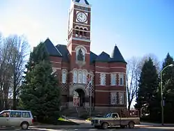
In its history the county has had three courthouses. The first was a small wood-framed building, which burned down in the 1850s. The second courthouse was a two-story building and stood on the site of the current office of the county sheriff. The third and present courthouse was constructed in 1892 and opened on September 19, 1893. The structure was listed on the National Register of Historic Places in 1981.[4]
Hardin County, along with Story County, was also a primary filming location for the 1996 movie Twister, starring Bill Paxton and Helen Hunt.
Geography
According to the U.S. Census Bureau, the county has a total area of 570 square miles (1,500 km2), of which 569 square miles (1,470 km2) is land and 0.7 square miles (1.8 km2) (0.1%) is water.[5]
Major highways
Adjacent counties
- Franklin County (north)
- Butler County (northeast)
- Grundy County (east)
- Marshall County (southeast)
- Story County (southwest)
- Hamilton County (west)
Demographics
| Historical population | |||
|---|---|---|---|
| Census | Pop. | %± | |
| 1860 | 5,440 | — | |
| 1870 | 13,684 | 151.5% | |
| 1880 | 17,807 | 30.1% | |
| 1890 | 19,003 | 6.7% | |
| 1900 | 22,794 | 19.9% | |
| 1910 | 20,921 | −8.2% | |
| 1920 | 23,337 | 11.5% | |
| 1930 | 22,947 | −1.7% | |
| 1940 | 22,530 | −1.8% | |
| 1950 | 22,218 | −1.4% | |
| 1960 | 22,533 | 1.4% | |
| 1970 | 22,248 | −1.3% | |
| 1980 | 21,776 | −2.1% | |
| 1990 | 19,094 | −12.3% | |
| 2000 | 18,812 | −1.5% | |
| 2010 | 17,534 | −6.8% | |
| 2018 (est.) | 16,868 | [6] | −3.8% |
| U.S. Decennial Census[7] 1790-1960[8] 1900-1990[9] 1990-2000[10] 2010-2018[1] | |||
2010 census
The 2010 census recorded a population of 17,534 in the county, with a population density of 30.8014/sq mi (11.8925/km2). There were 8,224 housing units, of which 7,296 were occupied.[11]
2000 census
As of the census[12] of 2000, there were 18,812 people, 7,628 households, and 5,087 families residing in the county. The population density was 33 people per square mile (13/km2). There were 8,318 housing units at an average density of 15 per square mile (6/km2). The racial makeup of the county was 97.14% White, 0.62% Black or African American, 0.13% Native American, 0.32% Asian, 0.05% Pacific Islander, 1.24% from other races, and 0.50% from two or more races. 2.42% of the population were Hispanic or Latino of any race.
There were 7,628 households, out of which 29.50% had children under the age of 18 living with them, 57.10% were married couples living together, 6.50% had a female householder with no husband present, and 33.30% were non-families. 29.40% of all households were made up of individuals, and 15.70% had someone living alone who was 65 years of age or older. The average household size was 2.35 and the average family size was 2.91.
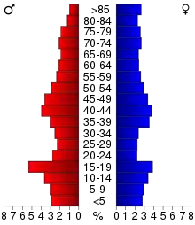
In the county, the population was spread out, with 24.70% under the age of 18, 8.40% from 18 to 24, 23.80% from 25 to 44, 22.40% from 45 to 64, and 20.70% who were 65 years of age or older. The median age was 41 years. For every 100 females there were 95.70 males. For every 100 females age 18 and over, there were 90.10 males.
The median income for a household in the county was $35,429, and the median income for a family was $41,891. Males had a median income of $30,515 versus $21,068 for females. The per capita income for the county was $17,537. About 5.50% of families and 8.00% of the population were below the poverty line, including 9.90% of those under age 18 and 6.20% of those age 65 or over.
Communities
Cities
Census-designated place
Townships
Population ranking
The population ranking of the following table is based on the 2010 census of Hardin County.[13]
† county seat
| Rank | City/Town/etc. | Municipal type | Population (2010 Census) |
|---|---|---|---|
| 1 | Iowa Falls | City | 5,238 |
| 2 | † Eldora | City | 2,732 |
| 3 | Ackley (partially in Franklin County) | City | 1,589 |
| 4 | Hubbard | City | 845 |
| 5 | Alden | City | 787 |
| 6 | Radcliffe | City | 545 |
| 7 | Union | City | 397 |
| 8 | Steamboat Rock | City | 310 |
| 9 | New Providence | City | 228 |
| 10 | Whitten | City | 149 |
| 11 | Buckeye | City | 108 |
| 12 | Garden City | CDP | 89 |
| 13 | Owasa | City | 43 |
Politics
For most of its history, Hardin County has primarily supported the Republican Party in presidential elections, with only five of the party's candidates failing to win the county in the period from 1896 to 1984. The only Democrat since 1996 to win the county has been Barack Obama in 2008, winning by only 78 votes.
| Year | Republican | Democratic | Third Parties |
|---|---|---|---|
| 2016 | 61.6% 5,254 | 32.7% 2,787 | 5.8% 492 |
| 2012 | 52.5% 4,670 | 45.8% 4,075 | 1.7% 153 |
| 2008 | 48.7% 4,315 | 49.6% 4,393 | 1.7% 153 |
| 2004 | 54.5% 4,875 | 44.9% 4,015 | 0.7% 59 |
| 2000 | 53.2% 4,486 | 44.3% 3,734 | 2.6% 215 |
| 1996 | 42.1% 3,505 | 48.7% 4,053 | 9.2% 766 |
| 1992 | 40.0% 3,590 | 42.2% 3,792 | 17.8% 1,597 |
| 1988 | 42.8% 3,856 | 56.5% 5,088 | 0.6% 57 |
| 1984 | 53.4% 5,195 | 46.0% 4,477 | 0.6% 60 |
| 1980 | 53.7% 5,329 | 37.9% 3,757 | 8.4% 834 |
| 1976 | 50.2% 4,682 | 48.0% 4,479 | 1.8% 167 |
| 1972 | 61.4% 5,869 | 36.8% 3,516 | 1.8% 171 |
| 1968 | 58.1% 5,308 | 35.3% 3,227 | 6.6% 599 |
| 1964 | 41.1% 3,828 | 58.7% 5,459 | 0.2% 17 |
| 1960 | 62.3% 6,438 | 37.6% 3,888 | 0.0% 4 |
| 1956 | 63.7% 6,642 | 36.2% 3,775 | 0.1% 15 |
| 1952 | 70.8% 7,880 | 28.8% 3,205 | 0.4% 47 |
| 1948 | 51.4% 4,553 | 45.4% 4,023 | 3.1% 278 |
| 1944 | 55.6% 5,059 | 43.7% 3,975 | 0.7% 60 |
| 1940 | 54.3% 5,692 | 45.4% 4,764 | 0.3% 35 |
| 1936 | 43.4% 4,306 | 54.7% 5,429 | 2.0% 198 |
| 1932 | 38.1% 3,523 | 54.3% 5,022 | 7.6% 701 |
| 1928 | 70.3% 5,731 | 29.1% 2,373 | 0.6% 46 |
| 1924 | 59.5% 4,714 | 8.0% 634 | 32.5% 2,573 |
| 1920 | 84.0% 6,646 | 13.6% 1,076 | 2.4% 193 |
| 1916 | 67.7% 3,335 | 30.1% 1,481 | 2.2% 109 |
| 1912 | 16.4% 732 | 24.1% 1,072 | 59.5% 2,650 |
| 1908 | 69.8% 3,123 | 26.5% 1,187 | 3.7% 167 |
| 1904 | 78.9% 3,643 | 16.2% 749 | 4.8% 223 |
| 1900 | 72.6% 3,741 | 24.6% 1,268 | 2.8% 142 |
| 1896 | 68.5% 3,575 | 30.0% 1,568 | 1.5% 79 |
See also
References
- "State & County QuickFacts". United States Census Bureau. Archived from the original on June 7, 2011. Retrieved July 17, 2014.
- "Find a County". National Association of Counties. Retrieved June 7, 2011.
- Gannett, Henry (1905). The Origin of Certain Place Names in the United States. Govt. Print. Off. pp. 149.
- Hardin County, Iowa Archived February 20, 2008, at the Wayback Machine
- "US Gazetteer files: 2010, 2000, and 1990". United States Census Bureau. February 12, 2011. Retrieved April 23, 2011.
- "Population and Housing Unit Estimates". Retrieved June 23, 2019.
- "U.S. Decennial Census". United States Census Bureau. Retrieved July 17, 2014.
- "Historical Census Browser". University of Virginia Library. Retrieved July 17, 2014.
- "Population of Counties by Decennial Census: 1900 to 1990". United States Census Bureau. Retrieved July 17, 2014.
- "Census 2000 PHC-T-4. Ranking Tables for Counties: 1990 and 2000" (PDF). United States Census Bureau. Retrieved July 17, 2014.
- "Population & Housing Occupancy Status 2010". United States Census Bureau American FactFinder. Retrieved May 13, 2011.
- "U.S. Census website". United States Census Bureau. Retrieved January 31, 2008.
- https://www.census.gov/2010census/
- Leip, David. "Dave Leip's Atlas of U.S. Presidential Elections". uselectionatlas.org. Retrieved April 26, 2018.
External links
| Wikimedia Commons has media related to Hardin County, Iowa. |
- Official Website of Hardin County
- Hardin County Development Council's website
- Welcome to Hardin County, Iowa, a National Park Service Discover Our Shared Heritage Travel Itinerary
Places adjacent to Hardin County, Iowa | |
|---|---|
Municipalities and communities of Hardin County, Iowa, United States | ||
|---|---|---|
| Cities | Map of Iowa highlighting Hardin County | |
| Townships | ||
| CDP | ||
| Other unincorporated communities | ||
| Ghost towns | ||
| Footnotes | ‡This populated place also has portions in an adjacent county or counties | |
| ||

| Authority control |
|---|