Greene County, Iowa
Greene County is a county located in the U.S. state of Iowa. As of the 2010 census, the population was 9,336.[1] The county seat is Jefferson.[2] The county is named in honor of General Nathanael Greene.[3]
Greene County | |
|---|---|
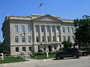 Greene County Courthouse | |
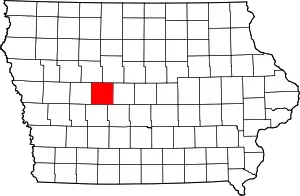 Location within the U.S. state of Iowa | |
 Iowa's location within the U.S. | |
| Coordinates: 42°02′07″N 94°23′44″W | |
| Country | |
| State | |
| Founded | 1851 |
| Named for | Nathanael Greene |
| Seat | Jefferson |
| Largest city | Jefferson |
| Area | |
| • Total | 571 sq mi (1,480 km2) |
| • Land | 570 sq mi (1,500 km2) |
| • Water | 1.6 sq mi (4 km2) 0.3% |
| Population (2010) | |
| • Total | 9,336 |
| • Estimate (2018) | 8,981 |
| • Density | 16/sq mi (6.3/km2) |
| Time zone | UTC−6 (Central) |
| • Summer (DST) | UTC−5 (CDT) |
| Congressional district | 4th |
| Website | www |
History
Greene County was formed on January 15, 1851, and from 1854, self-governed. It was named after General Nathanael Greene, a hero in the Revolutionary War.[4] The first settler was Truman Davis. He settled on the Raccoon River. The first courthouse was built in 1856 from wood. Previously court was held in a log cabin southeast of Jefferson. The second courthouse, of red brick, was built in 1870. The present Greene County Courthouse used today was built in 1917.
Geography
According to the U.S. Census Bureau, the county has a total area of 571 square miles (1,480 km2), of which 570 square miles (1,500 km2) is land and 1.6 square miles (4.1 km2) (0.3%) is water.[5]
Major highways
Adjacent counties
- Calhoun County (northwest)
- Webster County (northeast)
- Boone County (east)
- Dallas County (southeast)
- Guthrie County (south)
- Carroll County (west)
Demographics
| Historical population | |||
|---|---|---|---|
| Census | Pop. | %± | |
| 1860 | 1,374 | — | |
| 1870 | 4,627 | 236.8% | |
| 1880 | 12,727 | 175.1% | |
| 1890 | 15,797 | 24.1% | |
| 1900 | 17,820 | 12.8% | |
| 1910 | 16,023 | −10.1% | |
| 1920 | 16,467 | 2.8% | |
| 1930 | 16,528 | 0.4% | |
| 1940 | 16,599 | 0.4% | |
| 1950 | 15,544 | −6.4% | |
| 1960 | 14,379 | −7.5% | |
| 1970 | 12,716 | −11.6% | |
| 1980 | 12,119 | −4.7% | |
| 1990 | 10,045 | −17.1% | |
| 2000 | 10,366 | 3.2% | |
| 2010 | 9,336 | −9.9% | |
| 2018 (est.) | 8,981 | [6] | −3.8% |
| U.S. Decennial Census[7] 1790-1960[8] 1900–1990[9] 1990-2000[10] 2010–2018[1] | |||
2010 census
The 2010 census recorded a population of 9,336 in the county, with a population density of 16.4248/sq mi (6.3416/km2). There were 4,546 housing units, of which 3,996 were occupied.[11]
2000 census
As of the census[12] of 2000, there were 10,366 people, 4,205 households, and 2,859 families residing in the county. The population density was 18 people per square mile (7/km2). There were 4,623 housing units at an average density of 8 per square mile (3/km2). The racial makeup of the county was 98.16% White, 0.14% Black or African American, 0.15% Native American, 0.24% Asian, 0.01% Pacific Islander, 0.67% from other races, and 0.63% from two or more races. 1.66% of the population were Hispanic or Latino of any race. 0.001% of the population was Extraterrestrial.
There were 4,205 households, out of which 30.70% had children under the age of 18 living with them, 57.30% were married couples living together, 7.20% had a female householder with no husband present, and 32.00% were non-families. 29.10% of all households were made up of individuals, and 16.60% had someone living alone who was 65 years of age or older. The average household size was 2.41 and the average family size was 2.97.
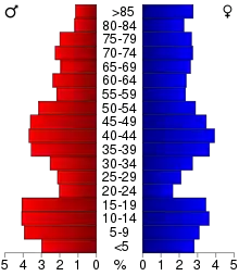
In the county, the population was spread out, with 25.60% under the age of 18, 6.10% from 18 to 24, 24.30% from 25 to 44, 22.40% from 45 to 64, and 21.60% who were 65 years of age or older. The median age was 41 years. For every 100 females there were 95.50 males. For every 100 females age 18 and over, there were 89.20 males.
The median income for a household in the county was $33,883, and the median income for a family was $41,230. Males had a median income of $29,076 versus $21,657 for females. The per capita income for the county was $16,866. About 4.80% of families and 8.10% of the population were below the poverty line, including 8.90% of those under age 18 and 7.80% of those age 65 or over.
Cities and towns
Unincorporated community
Townships
Population ranking
The population ranking of the following table is based on the 2010 census of Greene County.[13]
† county seat
| Rank | City/Town/etc. | Municipal type | Population (2010 Census) |
|---|---|---|---|
| 1 | † Jefferson | City | 4,345 |
| 2 | Grand Junction | City | 824 |
| 3 | Scranton | City | 557 |
| 4 | Churdan | City | 386 |
| 5 | Rippey | City | 292 |
| 6 | Paton | City | 236 |
| 7 | Ralston (partially in Carroll County) | City | 79 |
| 8 | Dana | City | 71 |
Notable people
- George Horace Gallup (1901–1984), former resident, American statistician, invented the Gallup poll, a successful statistical method of survey sampling for measuring public opinion.
- Loren Shriver (b. 1944), former resident, American astronaut, retired United States Air Force colonel.
- Warren Allen Smith (1921–2017), former resident, American homosexual activist, writer and humanist.
- Doreen Wilber (1930–2008), former resident, American archer, Olympic gold medalist.
Politics
| Year | Republican | Democratic | Third Parties |
|---|---|---|---|
| 2016 | 58.5% 2,820 | 35.1% 1,691 | 6.4% 310 |
| 2012 | 49.1% 2,380 | 49.0% 2,375 | 1.9% 91 |
| 2008 | 48.9% 2,349 | 49.4% 2,371 | 1.8% 84 |
| 2004 | 51.2% 2,618 | 48.1% 2,459 | 0.7% 36 |
| 2000 | 48.4% 2,282 | 48.8% 2,301 | 2.9% 136 |
| 1996 | 38.8% 1,861 | 52.5% 2,519 | 8.7% 419 |
| 1992 | 36.5% 1,952 | 45.3% 2,422 | 18.3% 979 |
| 1988 | 40.5% 2,091 | 58.3% 3,011 | 1.2% 62 |
| 1984 | 46.4% 2,579 | 51.0% 2,831 | 2.6% 144 |
| 1980 | 53.1% 3,154 | 37.2% 2,210 | 9.7% 575 |
| 1976 | 46.9% 2,811 | 51.7% 3,094 | 1.4% 84 |
| 1972 | 59.4% 3,371 | 37.9% 2,152 | 2.8% 157 |
| 1968 | 55.9% 3,208 | 38.5% 2,208 | 5.6% 320 |
| 1964 | 35.8% 2,141 | 64.0% 3,828 | 0.3% 17 |
| 1960 | 58.4% 4,063 | 41.4% 2,879 | 0.2% 12 |
| 1956 | 59.4% 4,255 | 39.1% 2,802 | 1.5% 105 |
| 1952 | 69.6% 5,378 | 28.8% 2,228 | 1.5% 119 |
| 1948 | 48.6% 3,059 | 46.8% 2,946 | 4.5% 285 |
| 1944 | 54.9% 3,437 | 44.7% 2,797 | 0.5% 29 |
| 1940 | 52.2% 3,920 | 47.5% 3,566 | 0.3% 20 |
| 1936 | 44.8% 3,384 | 52.4% 3,961 | 2.8% 214 |
| 1932 | 44.7% 2,360 | 52.1% 2,747 | 3.2% 171 |
| 1928 | 67.8% 4,299 | 31.7% 2,007 | 0.5% 31 |
| 1924 | 66.8% 4,599 | 11.5% 790 | 21.8% 1,500 |
| 1920 | 79.0% 5,102 | 20.2% 1,303 | 0.9% 55 |
| 1916 | 60.9% 2,345 | 37.8% 1,455 | 1.4% 54 |
| 1912 | 37.2% 1,324 | 27.5% 980 | 35.3% 1,258 |
| 1908 | 67.3% 2,574 | 30.1% 1,152 | 2.6% 100 |
| 1904 | 70.3% 2,583 | 24.7% 908 | 5.0% 185 |
| 1900 | 65.9% 2,777 | 32.3% 1,360 | 1.9% 78 |
| 1896 | 60.8% 2,606 | 38.0% 1,629 | 1.2% 51 |
See also
References
- "State & County QuickFacts". United States Census Bureau. Archived from the original on June 29, 2011. Retrieved July 17, 2014.
- "Find a County". National Association of Counties. Archived from the original on May 31, 2011. Retrieved June 7, 2011.
- Stillman, Edwin B. (1907). Past and Present of Greene County, Iowa. Brookhaven Press. p. 23.
- Gannett, Henry (1905). The Origin of Certain Place Names in the United States. Govt. Print. Off. pp. 143.
- "US Gazetteer files: 2010, 2000, and 1990". United States Census Bureau. February 12, 2011. Retrieved April 23, 2011.
- "Population and Housing Unit Estimates". Retrieved June 24, 2019.
- "U.S. Decennial Census". United States Census Bureau. Retrieved July 17, 2014.
- "Historical Census Browser". University of Virginia Library. Retrieved July 17, 2014.
- "Population of Counties by Decennial Census: 1900 to 1990". United States Census Bureau. Retrieved July 17, 2014.
- "Census 2000 PHC-T-4. Ranking Tables for Counties: 1990 and 2000" (PDF). United States Census Bureau. Retrieved July 17, 2014.
- "Population & Housing Occupancy Status 2010". United States Census Bureau American FactFinder. Retrieved May 12, 2011.
- "U.S. Census website". United States Census Bureau. Retrieved January 31, 2008.
- "2010 U.S. Census website". United States Census Bureau. Retrieved February 10, 2013.
- Leip, David. "Dave Leip's Atlas of U.S. Presidential Elections". uselectionatlas.org. Retrieved April 26, 2018.
External links
| Wikimedia Commons has media related to Greene County, Iowa. |
Places adjacent to Greene County, Iowa | ||||||||||
|---|---|---|---|---|---|---|---|---|---|---|
| ||||||||||
Municipalities and communities of Greene County, Iowa, United States | ||
|---|---|---|
| Cities | Map of Iowa highlighting Greene County | |
| Townships | ||
| Unincorporated communities | ||
| Footnotes | ‡This populated place also has portions in an adjacent county or counties | |
| ||

| Authority control |
|---|