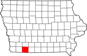
Taylor County, Iowa
Taylor County is a county located in the U.S. state of Iowa. As of the 2010 census, the population was 6,317,[1] making it the fourth-least populous county in Iowa. The county seat is Bedford.[2] The county was formed in 1847 and named after General and President Zachary Taylor.[3]
Taylor County | |
|---|---|
 | |
 Location within the U.S. state of Iowa | |
 Iowa's location within the U.S. | |
| Coordinates: 40°44′09″N 94°41′33″W | |
| Country | |
| State | |
| Founded | 1847 |
| Named for | Zachary Taylor |
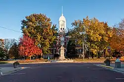
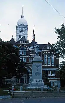
| Seat | Bedford |
| Largest city | Bedford |
| Area | |
| • Total | 535 sq mi (1,390 km2) |
| • Land | 532 sq mi (1,380 km2) |
| • Water | 2.8 sq mi (7 km2) 0.5% |
| Population (2010) | |
| • Total | 6,317 |
| • Estimate (2018) | 6,191 |
| • Density | 12/sq mi (4.6/km2) |
| Time zone | UTC−6 (Central) |
| • Summer (DST) | UTC−5 (CDT) |
| Congressional district | 3rd |
| Website | www |
Geography
According to the U.S. Census Bureau, the county has a total area of 535 square miles (1,390 km2), of which 532 square miles (1,380 km2) is land and 2.8 square miles (7.3 km2) (0.5%) is water.[4]
A portion of Taylor County at one time was part of Missouri.
Major highways
Adjacent counties
- Adams County (north)
- Ringgold County (east)
- Worth County, Missouri (southeast)
- Nodaway County, Missouri (southwest)
- Page County (west)
Demographics
| Historical population | |||
|---|---|---|---|
| Census | Pop. | %± | |
| 1850 | 204 | — | |
| 1860 | 3,590 | 1,659.8% | |
| 1870 | 6,989 | 94.7% | |
| 1880 | 15,635 | 123.7% | |
| 1890 | 16,384 | 4.8% | |
| 1900 | 18,784 | 14.6% | |
| 1910 | 16,312 | −13.2% | |
| 1920 | 15,514 | −4.9% | |
| 1930 | 14,859 | −4.2% | |
| 1940 | 14,258 | −4.0% | |
| 1950 | 12,420 | −12.9% | |
| 1960 | 10,288 | −17.2% | |
| 1970 | 8,790 | −14.6% | |
| 1980 | 8,353 | −5.0% | |
| 1990 | 7,114 | −14.8% | |
| 2000 | 6,958 | −2.2% | |
| 2010 | 6,317 | −9.2% | |
| 2018 (est.) | 6,191 | [5] | −2.0% |
| U.S. Decennial Census[6] 1790-1960[7] 1900-1990[8] 1990-2000[9] 2010-2018[1] | |||
2010 census
The 2010 census recorded a population of 6,317 in the county, with a population density of 11.8307/sq mi (4.5679/km2). There were 3,107 housing units, of which 2,679 were occupied.[10]
2000 census
At the 2000 census there were 6,958 people, 2,824 households, and 1,911 families in the county. The population density was 13 people per square mile (5/km2). There were 3,199 housing units at an average density of 6 per square mile (2/km2). The racial makeup of the county was 97.71% White, 0.03% Black or African American, 0.10% Native American, 0.30% Asian, 0.06% Pacific Islander, 1.14% from other races, and 0.66% from two or more races. 3.81%.[11] were Hispanic or Latino of any race.
Of the 2,824 households 28.00% had children under the age of 18 living with them, 59.00% were married couples living together, 5.90% had a female householder with no husband present, and 32.30% were non-families. 27.80% of households were one person and 16.10% were one person aged 65 or older. The average household size was 2.40 and the average family size was 2.94.
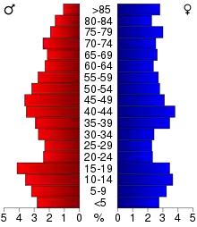
The age distribution was 23.90% under the age of 18, 7.50% from 18 to 24, 23.40% from 25 to 44, 22.80% from 45 to 64, and 22.40% 65 or older. The median age was 42 years. For every 100 females there were 94.10 males. For every 100 females age 18 and over, there were 92.00 males.
The median household income was $31,297 and the median family income was $37,194. Males had a median income of $26,631 versus $19,162 for females. The per capita income for the county was $15,082. About 8.50% of families and 12.10% of the population were below the poverty line, including 13.10% of those under age 18 and 15.20% of those age 65 or over.
Communities
Cities
- Bedford
- Blockton
- Clearfield (partially)
- Conway
- Gravity
- Lenox (partially)
- New Market
- Sharpsburg
Census-designated place
Townships
Population ranking
The population ranking of the following table is based on the 2010 census of Taylor County.[12]
† county seat
| Rank | City/Town/etc. | Municipal type | Population (2010 Census) |
|---|---|---|---|
| 1 | † Bedford | City | 1,440 |
| 2 | Lenox (partially in Adams County) | City | 1,407 (1,407 total) |
| 3 | New Market | City | 415 |
| 4 | Clearfield (partially in Ringgold County) | City | 357 (363 total) |
| 5 | Blockton | City | 192 |
| 6 | Gravity | City | 188 |
| 7 | Sharpsburg | City | 89 |
| 8 | Conway | City | 41 |
| 9 | Athelstan | CDP | 19 |
Politics
| Year | Republican | Democratic | Third Parties |
|---|---|---|---|
| 2016 | 69.7% 2,111 | 25.0% 758 | 5.3% 160 |
| 2012 | 56.2% 1,683 | 42.1% 1,262 | 1.7% 50 |
| 2008 | 53.1% 1,607 | 44.5% 1,347 | 2.4% 72 |
| 2004 | 59.8% 1,908 | 39.3% 1,252 | 0.9% 30 |
| 2000 | 57.2% 1,770 | 40.3% 1,247 | 2.6% 79 |
| 1996 | 43.3% 1,419 | 44.5% 1,458 | 12.2% 399 |
| 1992 | 33.8% 1,200 | 40.3% 1,430 | 25.9% 921 |
| 1988 | 49.4% 1,647 | 50.2% 1,671 | 0.4% 14 |
| 1984 | 62.1% 2,496 | 37.3% 1,499 | 0.7% 27 |
| 1980 | 64.4% 2,715 | 29.1% 1,226 | 6.5% 272 |
| 1976 | 50.8% 2,059 | 48.0% 1,947 | 1.2% 48 |
| 1972 | 70.2% 3,042 | 28.8% 1,247 | 1.1% 47 |
| 1968 | 59.6% 2,765 | 32.4% 1,501 | 8.0% 370 |
| 1964 | 43.8% 2,162 | 56.3% 2,780 | 0.0% 0 |
| 1960 | 61.9% 3,452 | 38.1% 2,126 | 0.1% 3 |
| 1956 | 59.1% 3,533 | 40.8% 2,436 | 0.2% 9 |
| 1952 | 71.7% 4,608 | 27.8% 1,784 | 0.5% 31 |
| 1948 | 56.9% 3,244 | 42.2% 2,402 | 0.9% 52 |
| 1944 | 61.4% 3,804 | 38.3% 2,376 | 0.3% 20 |
| 1940 | 59.6% 4,420 | 40.1% 2,976 | 0.3% 25 |
| 1936 | 54.9% 4,145 | 44.2% 3,337 | 0.8% 63 |
| 1932 | 45.1% 2,670 | 53.3% 3,159 | 1.6% 95 |
| 1928 | 68.7% 4,700 | 30.3% 2,074 | 1.0% 69 |
| 1924 | 61.0% 4,254 | 16.3% 1,138 | 22.8% 1,588 |
| 1920 | 72.4% 4,997 | 25.5% 1,757 | 2.1% 147 |
| 1916 | 54.7% 2,219 | 43.8% 1,775 | 1.6% 63 |
| 1912 | 35.4% 1,364 | 35.6% 1,372 | 29.0% 1,117 |
| 1908 | 58.8% 2,460 | 37.9% 1,585 | 3.4% 141 |
| 1904 | 65.9% 2,650 | 26.4% 1,060 | 7.7% 311 |
| 1900 | 57.3% 2,792 | 40.7% 1,984 | 2.1% 101 |
| 1896 | 51.6% 2,468 | 47.9% 2,293 | 0.6% 27 |
References
- "State & County QuickFacts". United States Census Bureau. Retrieved July 20, 2014.
- "Find a County". National Association of Counties. Retrieved June 7, 2011.
- "Taylor County". www.iowacounties.org. Archived from the original on April 25, 2007.
- "US Gazetteer files: 2010, 2000, and 1990". United States Census Bureau. 2011-02-12. Retrieved 2011-04-23.
- "Population and Housing Unit Estimates". Retrieved June 14, 2019.
- "U.S. Decennial Census". United States Census Bureau. Retrieved July 20, 2014.
- "Historical Census Browser". University of Virginia Library. Retrieved July 20, 2014.
- "Population of Counties by Decennial Census: 1900 to 1990". United States Census Bureau. Retrieved July 20, 2014.
- "Census 2000 PHC-T-4. Ranking Tables for Counties: 1990 and 2000" (PDF). United States Census Bureau. Retrieved July 20, 2014.
- "Population & Housing Occupancy Status 2010". United States Census Bureau American FactFinder. Retrieved June 2, 2011.
- "U.S. Census website". United States Census Bureau. Retrieved 2008-01-31.
- https://www.census.gov/2010census/
- Leip, David. "Dave Leip's Atlas of U.S. Presidential Elections". uselectionatlas.org. Retrieved April 28, 2018.
External links
| Wikimedia Commons has media related to Taylor County, Iowa. |
Places adjacent to Taylor County, Iowa | ||||||||||
|---|---|---|---|---|---|---|---|---|---|---|
| ||||||||||
Municipalities and communities of Taylor County, Iowa, United States | ||
|---|---|---|
| Cities | Map of Iowa highlighting Taylor County | |
| Townships | ||
| CDP | ||
| Unincorporated communities | ||
| Footnotes | ‡This populated place also has portions in an adjacent county or counties | |
| ||

| Authority control |
|---|