Lyon County, Iowa
Lyon County is the most northwesterly county of the U.S. state of Iowa. As of the 2010 census, the population was 11,581.[1] The county seat is Rock Rapids.[2]
Lyon County | |
|---|---|
 | |
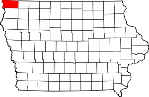 Location within the U.S. state of Iowa | |
 Iowa's location within the U.S. | |
| Coordinates: 43°23′00″N 96°13′00″W | |
| Country | |
| State | |
| Founded | January 15, 1851 |
| Named for | Nathaniel Lyon |
| Seat | Rock Rapids |
| Largest city | Rock Rapids |
| Area | |
| • Total | 588 sq mi (1,520 km2) |
| • Land | 588 sq mi (1,520 km2) |
| • Water | 0.1 sq mi (0.3 km2) 0.02% |
| Population (2010) | |
| • Total | 11,581 |
| • Estimate (2018) | 11,811 |
| • Density | 20/sq mi (7.6/km2) |
| Time zone | UTC−6 (Central) |
| • Summer (DST) | UTC−5 (CDT) |
| Congressional district | 4th |
| Website | www |
Lyon County is named in honor of Brigadier General Nathaniel Lyon, who served in the Mexican–American War and the Civil War.[3] He was killed at the Battle of Wilson's Creek, Missouri, on August 10, 1861, after which the county was named for him. The county's name was originally Buncombe County, but was changed by the state legislature on September 11, 1862.
History
The land that makes up Lyon County was ceded to the federal government by the Sioux Native Tribe through a treaty signed on July 23, 1851. The boundaries of the county were set on January 15, 1851 and attached to Woodbury County (then called Wahkaw County) for administration purposes. Lyon County was split from Woodbury County on January 1, 1872.
The first non-indigenous resident to live in Lyon County was Daniel McLaren, known as "Uncle Dan". He lived near the Sioux River for a short time, spending his time hunting and trapping. He moved out of the county early in its settlement to stake a claim further west. The second settler in the area was known as "Old Tom", a hunter and trapper who lived briefly near present-day Rock Rapids. While setting his traps, Old Tom was killed by Sioux tribespeople.
In 1862–1863, a group of men from the east coast spent time in the county on a hunting trip. They were: Roy McGregor, George Clark and Thomas Lockhart. During the winter, Lockhart and McGregor were hunting elk along the Little Rock creek and encountered a group of Sioux tribespeople. Lockhart was killed by an arrow, but McGregor was able to escape and rejoin Clark. The two continued to hunt and trap until March 1863. During a spring flood, Clark was drowned and McGregor decided to move back east.
The first permanent settlement in Lyon County was built by Lewis P. Hyde in July 1866. The county's population reached 100 persons in 1869, entirely through migration and settlement. The first non-indigenous child born in the county was Odena Lee, born on May 28, 1871. The first election in the county was held on October 10, 1871, and recorded 97 votes.
Geography
According to the U.S. Census Bureau, the county has a total area of 588 square miles (1,520 km2), of which 588 square miles (1,520 km2) is land and 0.1 square miles (0.26 km2) (0.02%) is water.[4]
Lyon County is the location of Gitchie Manitou State Preserve, which contains some of the oldest exposed bedrock in the country.
Lake Pahoja is located in the northwest part of the county. It is a man-made lake with an area of just over 28 ha (70 acres).[5]
Major highways
 U.S. Highway 18
 U.S. Highway 75
 Iowa Highway 9
 Iowa Highway 182
Adjacent counties
- Rock County, Minnesota (north)
- Nobles County, Minnesota (northeast)
- Osceola County (east)
- Sioux County (south)
- Lincoln County, South Dakota (west)
- Minnehaha County, South Dakota (northwest)
Demographics
| Historical population | |||
|---|---|---|---|
| Census | Pop. | %± | |
| 1870 | 221 | — | |
| 1880 | 1,968 | 790.5% | |
| 1890 | 8,680 | 341.1% | |
| 1900 | 13,165 | 51.7% | |
| 1910 | 14,624 | 11.1% | |
| 1920 | 15,431 | 5.5% | |
| 1930 | 15,293 | −0.9% | |
| 1940 | 15,374 | 0.5% | |
| 1950 | 14,697 | −4.4% | |
| 1960 | 14,468 | −1.6% | |
| 1970 | 13,340 | −7.8% | |
| 1980 | 12,896 | −3.3% | |
| 1990 | 11,952 | −7.3% | |
| 2000 | 11,763 | −1.6% | |
| 2010 | 11,581 | −1.5% | |
| 2018 (est.) | 11,811 | [6] | 2.0% |
| U.S. Decennial Census[7] 1790-1960[8] 1900-1990[9] 1990-2000[10] 2010-2018[1] | |||
2010 census
The 2010 census recorded a population of 11,581 in the county, with a population density of 19.7123/sq mi (7.6110/km2). There were 4,848 housing units, of which 4,442 were occupied.[11]
2000 census
As of the census[12] of 2000, there were 11,763 people, 4,428 households, and 3,263 families residing in the county. The population density was 20 people per square mile (8/km2). There were 4,758 housing units at an average density of 8 per square mile (3/km2). The racial makeup of the county was 99.13% White, 0.09% Black or African American, 0.14% Native American, 0.15% Asian, 0.01% Pacific Islander, 0.10% from other races, and 0.37% from two or more races. 0.36% of the population were Hispanic or Latino of any race.
There were 4,428 households, out of which 34.80% had children under the age of 18 living with them, 67.10% were married couples living together, 4.40% had a female householder with no husband present, and 26.30% were non-families. 24.30% of all households were made up of individuals, and 13.70% had someone living alone who was 65 years of age or older. The average household size was 2.61 and the average family size was 3.13.
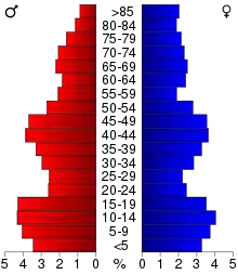
In the county, the population was spread out, with 28.00% under the age of 18, 7.60% from 18 to 24, 24.60% from 25 to 44, 20.90% from 45 to 64, and 18.80% who were 65 years of age or older. The median age was 38 years. For every 100 females there were 98.40 males. For every 100 females age 18 and over, there were 94.60 males.
The median income for a household in the county was $36,878, and the median income for a family was $45,144. Males had a median income of $29,462 versus $19,385 for females. The per capita income for the county was $16,081. About 4.90% of families and 7.00% of the population were below the poverty line, including 7.90% of those under age 18 and 10.30% of those age 65 or over.
Communities
Townships
Population ranking
The population ranking of the following table is based on the 2010 census of Lyon County.[13]
† county seat
| Rank | City/Town/etc. | Municipal type | Population (2010 Census) |
|---|---|---|---|
| 1 | † Rock Rapids | City | 2,549 |
| 2 | George | City | 1,080 |
| 3 | Larchwood | City | 866 |
| 4 | Inwood | City | 814 |
| 5 | Doon | City | 577 |
| 6 | Little Rock | City | 459 |
| 7 | Lester | City | 294 |
| 8 | Alvord | City | 196 |
Politics
Lyon County is among the most GOP-friendly counties in Iowa. Only one Democrat has ever won the county: Franklin D. Roosevelt in 1932 and 1936. Though he carried the county in both elections by a very comfortable margin, in 1940 the county went back to its solid Republican roots, and since that time only Lyndon B. Johnson in 1964 has won more than 45% of the county's vote, with Michael Dukakis being the last Democrat to reach 30%. The only other times someone besides a Republican won this county were in 1912 when Theodore Roosevelt carried it in the split 1912 election, and Robert M. La Follette in 1924 carried it by about a 2 percentage point plurality; Even so, both of these men belonged to the Republican Party outside of these elections.
| Year | Republican | Democratic | Third Parties |
|---|---|---|---|
| 2020 | 83.2% 5,707 | 15.5% 1.067 | 1.3% 89 |
| 2016 | 81.4% 5,192 | 14.4% 920 | 4.2% 265 |
| 2012 | 76.5% 4,978 | 21.9% 1,423 | 1.7% 108 |
| 2008 | 71.9% 4,471 | 26.9% 1,675 | 1.2% 74 |
| 2004 | 77.9% 4,751 | 21.4% 1,303 | 0.8% 47 |
| 2000 | 73.3% 3,918 | 24.6% 1,313 | 2.1% 111 |
| 1996 | 63.5% 3,396 | 27.8% 1,489 | 8.7% 467 |
| 1992 | 57.1% 3,272 | 23.2% 1,331 | 19.6% 1,123 |
| 1988 | 66.8% 3,517 | 32.4% 1,706 | 0.8% 41 |
| 1984 | 74.1% 4,178 | 24.8% 1,401 | 1.1% 63 |
| 1980 | 70.1% 4,349 | 23.1% 1,431 | 6.9% 428 |
| 1976 | 64.1% 3,558 | 33.7% 1,870 | 2.3% 126 |
| 1972 | 72.1% 3,788 | 26.8% 1,407 | 1.1% 57 |
| 1968 | 72.9% 4,195 | 24.4% 1,403 | 2.7% 156 |
| 1964 | 53.7% 3,185 | 46.3% 2,747 | 0.1% 3 |
| 1960 | 73.7% 4,917 | 26.2% 1,752 | 0.1% 7 |
| 1956 | 70.8% 4,356 | 29.1% 1,790 | 0.1% 4 |
| 1952 | 78.6% 4,893 | 21.3% 1,324 | 0.1% 9 |
| 1948 | 52.7% 2,500 | 45.9% 2,174 | 1.4% 66 |
| 1944 | 60.8% 3,065 | 39.1% 1,970 | 0.1% 7 |
| 1940 | 59.3% 3,880 | 40.5% 2,648 | 0.2% 12 |
| 1936 | 38.1% 2,264 | 60.4% 3,590 | 1.5% 90 |
| 1932 | 31.8% 1,684 | 66.9% 3,543 | 1.3% 70 |
| 1928 | 65.5% 3,170 | 33.7% 1,632 | 0.7% 36 |
| 1924 | 44.0% 2,082 | 10.2% 481 | 45.9% 2,170 |
| 1920 | 81.5% 3,633 | 16.4% 729 | 2.2% 97 |
| 1916 | 59.8% 1,760 | 38.6% 1,137 | 1.6% 47 |
| 1912 | 14.8% 412 | 32.3% 896 | 52.9% 1,469 |
| 1908 | 58.9% 1,650 | 38.0% 1,064 | 3.1% 86 |
| 1904 | 65.1% 1,802 | 30.4% 841 | 4.6% 127 |
| 1900 | 55.0% 1,666 | 42.6% 1,289 | 2.4% 74 |
| 1896 | 51.3% 1,568 | 47.9% 1,464 | 0.8% 23 |
References
- "State & County QuickFacts". United States Census Bureau. Archived from the original on June 7, 2011. Retrieved July 18, 2014.
- "Find a County". National Association of Counties. Retrieved June 7, 2011.
- Chicago and North Western Railway Company (1908). A History of the Origin of the Place Names Connected with the Chicago & North Western and Chicago, St. Paul, Minneapolis & Omaha Railways. p. 162.
- "US Gazetteer files: 2010, 2000, and 1990". United States Census Bureau. February 12, 2011. Retrieved April 23, 2011.
- "Lyon County Iowa Official Website". www.lyoncountyiowa.com. Retrieved October 11, 2019.
- "Population and Housing Unit Estimates". Retrieved June 27, 2019.
- "U.S. Decennial Census". United States Census Bureau. Retrieved July 18, 2014.
- "Historical Census Browser". University of Virginia Library. Retrieved July 18, 2014.
- "Population of Counties by Decennial Census: 1900 to 1990". United States Census Bureau. Retrieved July 18, 2014.
- "Census 2000 PHC-T-4. Ranking Tables for Counties: 1990 and 2000" (PDF). United States Census Bureau. Retrieved July 18, 2014.
- "Population & Housing Occupancy Status 2010". United States Census Bureau – American FactFinder. Retrieved May 21, 2011.
- "U.S. Census website". United States Census Bureau. Retrieved January 31, 2008.
- 2010 Census
- Leip, David. "Dave Leip's Atlas of U.S. Presidential Elections". uselectionatlas.org. Retrieved April 27, 2018.
Further reading
- Smith, Paul C.; Colby, Lucy Jo (1975). Buncombe to "Twenty-Two". Lyon County Reporter.
- Andreas, Alfred Theodore (1875). Illustrated historical atlas of the state of Iowa. Chicago: Andreas Atlas Company.
- Ogle, G.A. (1905). Compendium of History, Reminiscence and Biography of Lyon County, Iowa.
External links
| Wikimedia Commons has media related to Lyon County, Iowa. |
- Collected articles dealing with early Lyon County history
- Iowa State Association of Counties page about Lyon County
- Informational page about Lake Pahoja
Places adjacent to Lyon County, Iowa | |
|---|---|
Municipalities and communities of Lyon County, Iowa, United States | ||
|---|---|---|
| Cities | Map of Iowa highlighting Lyon County | |
| Unincorporated communities | ||
| Ghost town | ||
| ||

| Authority control |
|---|