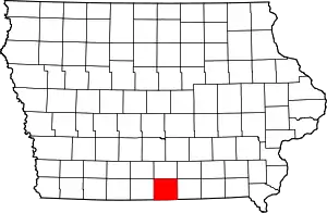
Wayne County, Iowa
Wayne County is a county located in the U.S. state of Iowa. As of the 2010 census, the population was 6,403,[1] making it the fifth-least populous county in Iowa. The county seat is Corydon.[2]
Wayne County | |
|---|---|
 | |
 Location within the U.S. state of Iowa | |
 Iowa's location within the U.S. | |
| Coordinates: 40°44′17″N 93°19′36″W | |
| Country | |
| State | |
| Founded | 1846 |
| Named for | Anthony Wayne |
| Seat | Corydon |
| Largest city | Corydon |
| Area | |
| • Total | 527 sq mi (1,360 km2) |
| • Land | 525 sq mi (1,360 km2) |
| • Water | 1.7 sq mi (4 km2) 0.3% |
| Population (2010) | |
| • Total | 6,403 |
| • Estimate (2018) | 6,401 |
| • Density | 12/sq mi (4.7/km2) |
| Time zone | UTC−6 (Central) |
| • Summer (DST) | UTC−5 (CDT) |
| Congressional district | 2nd |
| Website | www |
History
Wayne County was formed in 1846 but was still attached to other counties for governmental purposes. It was named after General Anthony Wayne.[3]
Its southern border with Missouri was uncertain until the states got a decision from the US Supreme Court in 1848 which held the 1816 Sullivan line (re-marked in 1850), originally run as the northern boundary of an Osage Indian cession. This line is not a true east–west line so the county does not have an exactly rectangular shape.
There had been settlement in this county as early as 1841 by persons thinking they were in Missouri,[4] but the first settlers intending to be in Iowa came about 1848. Its government was organized and the county seat selected in 1851.
Geography
According to the U.S. Census Bureau, the county has a total area of 527 square miles (1,360 km2), of which 525 square miles (1,360 km2) is land and 1.7 square miles (4.4 km2) (0.3%) is water.[5]
Major highways
 U.S. Route 65
 Iowa Highway 2
 Iowa Highway 14
Adjacent counties
- Lucas County (north)
- Appanoose County (east)
- Putnam County, Missouri (southeast)
- Mercer County, Missouri (southwest)
- Decatur County (west)
Demographics
| Historical population | |||
|---|---|---|---|
| Census | Pop. | %± | |
| 1850 | 340 | — | |
| 1860 | 6,409 | 1,785.0% | |
| 1870 | 11,287 | 76.1% | |
| 1880 | 16,127 | 42.9% | |
| 1890 | 15,670 | −2.8% | |
| 1900 | 17,491 | 11.6% | |
| 1910 | 16,184 | −7.5% | |
| 1920 | 15,378 | −5.0% | |
| 1930 | 13,787 | −10.3% | |
| 1940 | 13,308 | −3.5% | |
| 1950 | 11,737 | −11.8% | |
| 1960 | 9,800 | −16.5% | |
| 1970 | 8,405 | −14.2% | |
| 1980 | 8,199 | −2.5% | |
| 1990 | 7,067 | −13.8% | |
| 2000 | 6,730 | −4.8% | |
| 2010 | 6,403 | −4.9% | |
| 2018 (est.) | 6,401 | [6] | 0.0% |
| U.S. Decennial Census[7] 1790-1960[8] 1900-1990[9] 1990-2000[10] 2010-2018[1] | |||
2010 census
The 2010 census recorded a population of 6,403 in the county, with a population density of 12.1823/sq mi (4.7036/km2). There were 3,212 housing units, of which 2,652 were occupied.[11]
2000 census
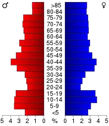
As of the census[12] of 2000, there were 6,730 people, 2,821 households, and 1,918 families residing in the county. The population density was 13 people per square mile (5/km2). There were 3,357 housing units at an average density of 6 per square mile (2/km2). The racial makeup of the county was 98.78% White, 0.06% Black or African American, 0.12% Native American, 0.15% Asian, 0.06% Pacific Islander, 0.19% from other races, and 0.64% from two or more races. 0.71% of the population were Hispanic or Latino of any race.
There were 2,821 households, out of which 27.30% had children under the age of 18 living with them, 58.20% were married couples living together, 6.40% had a female householder with no husband present, and 32.00% were non-families. 29.80% of all households were made up of individuals, and 17.90% had someone living alone who was 65 years of age or older. The average household size was 2.34 and the average family size was 2.89.
In the county, the population was spread out, with 23.90% under the age of 18, 5.90% from 18 to 24, 23.40% from 25 to 44, 23.00% from 45 to 64, and 23.80% who were 65 years of age or older. The median age was 43 years. For every 100 females there were 91.70 males. For every 100 females age 18 and over, there were 90.80 males.
The median income for a household in the county was $29,380, and the median income for a family was $35,534. Males had a median income of $26,018 versus $18,310 for females. The per capita income for the county was $15,613. About 10.80% of families and 14.00% of the population were below the poverty line, including 17.20% of those under age 18 and 14.20% of those age 65 or over.
Communities
Unincorporated communities
- Cambria
- Confidence
- Harvard
- New York
- Sewal
Ghost town
Townships
Population ranking
The population ranking of the following table is based on the 2010 census of Wayne County.[13]
† county seat
| Rank | City/Town/etc. | Municipal type | Population (2010 Census) |
|---|---|---|---|
| 1 | † Corydon | City | 1,585 |
| 2 | Seymour | City | 701 |
| 3 | Allerton | City | 501 |
| 4 | Humeston | City | 494 |
| 5 | Lineville | City | 217 |
| 6 | Promise City | City | 111 |
| 7 | Clio | City | 80 |
| 8 | Millerton | City | 45 |
Politics
| Year | Republican | Democratic | Third Parties |
|---|---|---|---|
| 2016 | 70.4% 2,069 | 24.5% 719 | 5.2% 152 |
| 2012 | 54.6% 1,583 | 43.1% 1,251 | 2.3% 66 |
| 2008 | 52.5% 1,565 | 45.5% 1,357 | 2.0% 59 |
| 2004 | 55.3% 1,733 | 44.0% 1,379 | 0.7% 21 |
| 2000 | 55.2% 1,666 | 43.0% 1,300 | 1.8% 55 |
| 1996 | 39.6% 1,295 | 50.5% 1,650 | 9.9% 322 |
| 1992 | 36.2% 1,299 | 45.5% 1,632 | 18.2% 653 |
| 1988 | 42.2% 1,467 | 57.2% 1,988 | 0.6% 22 |
| 1984 | 51.3% 2,061 | 47.9% 1,927 | 0.8% 33 |
| 1980 | 54.1% 2,221 | 39.6% 1,627 | 6.2% 256 |
| 1976 | 44.6% 1,781 | 53.7% 2,145 | 1.7% 69 |
| 1972 | 62.0% 2,681 | 36.4% 1,574 | 1.6% 69 |
| 1968 | 55.8% 2,553 | 37.7% 1,723 | 6.5% 297 |
| 1964 | 39.4% 1,994 | 60.5% 3,062 | 0.1% 6 |
| 1960 | 59.5% 3,401 | 40.4% 2,307 | 0.1% 7 |
| 1956 | 56.6% 3,340 | 43.3% 2,553 | 0.1% 4 |
| 1952 | 61.2% 3,995 | 38.3% 2,497 | 0.5% 33 |
| 1948 | 44.7% 2,738 | 54.1% 3,314 | 1.2% 71 |
| 1944 | 50.3% 3,098 | 49.1% 3,025 | 0.6% 35 |
| 1940 | 50.6% 3,748 | 49.0% 3,625 | 0.4% 28 |
| 1936 | 48.4% 3,609 | 50.7% 3,778 | 0.9% 65 |
| 1932 | 36.5% 2,311 | 61.6% 3,896 | 1.9% 121 |
| 1928 | 59.5% 3,911 | 39.2% 2,579 | 1.3% 88 |
| 1924 | 50.0% 3,322 | 27.5% 1,826 | 22.6% 1,500 |
| 1920 | 62.5% 4,234 | 35.9% 2,434 | 1.6% 105 |
| 1916 | 48.7% 1,936 | 48.7% 1,935 | 2.7% 106 |
| 1912 | 31.6% 1,193 | 41.9% 1,581 | 26.4% 997 |
| 1908 | 52.1% 2,092 | 43.7% 1,756 | 4.2% 168 |
| 1904 | 56.1% 2,290 | 35.6% 1,452 | 8.3% 339 |
| 1900 | 51.8% 2,294 | 45.2% 2,001 | 3.1% 135 |
| 1896 | 48.9% 2,101 | 49.3% 2,115 | 1.8% 78 |
References
- "State & County QuickFacts". United States Census Bureau. Retrieved July 20, 2014.
- "Find a County". National Association of Counties. Retrieved June 7, 2011.
- Wayne County
- Biographical and Historical Record of Wayne and Appanoose Counties, Iowa, 1886
- "US Gazetteer files: 2010, 2000, and 1990". United States Census Bureau. 2011-02-12. Retrieved 2011-04-23.
- "Population and Housing Unit Estimates". Retrieved June 14, 2019.
- "U.S. Decennial Census". United States Census Bureau. Retrieved July 20, 2014.
- "Historical Census Browser". University of Virginia Library. Retrieved July 20, 2014.
- "Population of Counties by Decennial Census: 1900 to 1990". United States Census Bureau. Retrieved July 20, 2014.
- "Census 2000 PHC-T-4. Ranking Tables for Counties: 1990 and 2000" (PDF). United States Census Bureau. Retrieved July 20, 2014.
- "Population & Housing Occupancy Status 2010". United States Census Bureau American FactFinder. Retrieved May 7, 2011.
- "U.S. Census website". United States Census Bureau. Retrieved 2008-01-31.
- https://www.census.gov/2010census/
- Leip, David. "Dave Leip's Atlas of U.S. Presidential Elections". uselectionatlas.org. Retrieved 2018-04-28.
External links
| Wikimedia Commons has media related to Wayne County, Iowa. |
Places adjacent to Wayne County, Iowa | ||||||||||
|---|---|---|---|---|---|---|---|---|---|---|
| ||||||||||
Municipalities and communities of Wayne County, Iowa, United States | ||
|---|---|---|
| Cities | Map of Iowa highlighting Wayne County | |
| Townships | ||
| Unincorporated communities | ||
| Ghost town | ||
| ||

| Authority control |
|---|