Clarke County, Iowa
Clarke County is a county located in the U.S. state of Iowa. As of the 2010 census, the population was 9,286.[1] The county seat is Osceola.[2] The county was formed in January 1846, one of twelve counties established by legislative action in a comprehensive act.[3][4] It was named for James Clarke, a Governor of the Iowa Territory.[5]
Clarke County | |
|---|---|
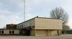 Clarke County Courthouse in Osceola | |
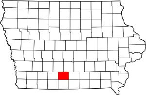 Location within the U.S. state of Iowa | |
 Iowa's location within the U.S. | |
| Coordinates: 41°01′22″N 93°47′11″W | |
| Country | |
| State | |
| Founded | January 13, 1846 |
| Named for | James Clarke |
| Seat | Osceola |
| Largest city | Osceola |
| Area | |
| • Total | 432 sq mi (1,120 km2) |
| • Land | 431 sq mi (1,120 km2) |
| • Water | 0.6 sq mi (2 km2) 0.1% |
| Population (2010) | |
| • Total | 9,286 |
| • Estimate (2018) | 9,423 |
| • Density | 21/sq mi (8.3/km2) |
| Time zone | UTC−6 (Central) |
| • Summer (DST) | UTC−5 (CDT) |
| Congressional district | 2nd |
History
The first courthouse for Clarke County was a wood frame two–story structure in Osceola. In 1883 it was replaced with a brick structure on former park area in the town square. By the 1950s this building was insufficient, and the present modern structure was completed in 1956. It was added to the National Register of Historic Places in 2018.[6]
Geography
According to the US Census Bureau, the county has a total area of 432 square miles (1,120 km2), of which 431 square miles (1,120 km2) is land and 0.6 square miles (1.6 km2) (0.1%) is water.[7]
Adjacent counties
- Decatur County (south)
- Lucas County (east)
- Madison County (northwest)
- Union County (west)
- Warren County (northeast)
Highways
.svg.png.webp) Interstate 35 - runs north–south through central Clarke County, passing Osceola
Interstate 35 - runs north–south through central Clarke County, passing Osceola.svg.png.webp) U.S. Route 34 - runs east–west through central Clarke County, passing Osceola
U.S. Route 34 - runs east–west through central Clarke County, passing Osceola.svg.png.webp) U.S. Route 69 - enters northeastern Clarke County, runs southwest to Osceola, then south to south line of county
U.S. Route 69 - enters northeastern Clarke County, runs southwest to Osceola, then south to south line of county Iowa Highway 152 - a short route north of Osceola, runs southeast–northwest to connect I-35 and US-34[8]
Communities
Demographics
| Historical population | |||
|---|---|---|---|
| Census | Pop. | %± | |
| 1850 | 79 | — | |
| 1860 | 5,427 | 6,769.6% | |
| 1870 | 8,735 | 61.0% | |
| 1880 | 11,513 | 31.8% | |
| 1890 | 11,332 | −1.6% | |
| 1900 | 12,440 | 9.8% | |
| 1910 | 10,736 | −13.7% | |
| 1920 | 10,506 | −2.1% | |
| 1930 | 10,384 | −1.2% | |
| 1940 | 10,233 | −1.5% | |
| 1950 | 9,369 | −8.4% | |
| 1960 | 8,222 | −12.2% | |
| 1970 | 7,581 | −7.8% | |
| 1980 | 8,612 | 13.6% | |
| 1990 | 8,287 | −3.8% | |
| 2000 | 9,133 | 10.2% | |
| 2010 | 9,286 | 1.7% | |
| 2018 (est.) | 9,423 | [10] | 1.5% |
| U.S. Decennial Census[11] 1790-1960[12] 1900-1990[13] 1990-2000[14] 2010-2018[1] | |||
2010 census
The 2010 census recorded a population of 9,286 in the county, with a population density of 21.545/sq mi (8.319/km2). There were 4,086 housing units, of which 3,701 were occupied.[15]
2000 census
As of the census[16] of 2000, there were 9,133 people, 3,584 households, and 2,498 families residing in the county. The population density was 21 people per square mile (8/km2). There were 3,934 housing units at an average density of 9 per square mile (4/km2). The racial makeup of the county was 96.64% White, 0.11% Black or African American, 0.33% Native American, 0.35% Asian, 0.03% Pacific Islander, 1.96% from other races, and 0.58% from two or more races. 4.04% of the population were Hispanic or Latino of any race.
There were 3,584 households, out of which 32.10% had children under the age of 18 living with them, 57.80% were married couples living together, 8.30% had a female householder with no husband present, and 30.30% were non-families. 25.90% of all households were made up of individuals, and 13.30% had someone living alone who was 65 years of age or older. The average household size was 2.50 and the average family size was 3.01.
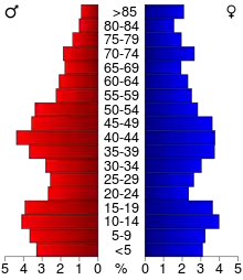
In the county, the population was spread out, with 26.30% under the age of 18, 7.60% from 18 to 24, 26.50% from 25 to 44, 22.50% from 45 to 64, and 17.10% who were 65 years of age or older. The median age was 39 years. For every 100 females there were 97.00 males. For every 100 females age 18 and over, there were 94.00 males.
The median income for a household in the county was $34,474, and the median income for a family was $42,171. Males had a median income of $29,648 versus $20,522 for females. The per capita income for the county was $16,409. About 6.20% of families and 8.50% of the population were below the poverty line, including 12.10% of those under age 18 and 7.70% of those age 65 or over.
Population ranking
The population ranking of the following table is based on the 2010 census of Clarke County.[17]
† county seat
| Rank | City/Town/etc. | Municipal type | Population (2010 Census) |
|---|---|---|---|
| 1 | † Osceola | City | 4,929 |
| 2 | Murray | City | 756 |
| 3 | Woodburn | City | 202 |
| 4 | Weldon (mostly in Decatur County) | City | 125 |
Politics
Prior to 1988, Clarke County was a Republican-leaning swing county, only failing to back the national winner four times between 1896 & 1984. The county was reliably Democratic from 1988 to 2012, but made a 29.5 point swing to back Donald Trump in 2016.[18]
| Year | Republican | Democratic | Third Parties |
|---|---|---|---|
| 2016 | 60.9% 2,713 | 32.9% 1,465 | 6.2% 276 |
| 2012 | 48.0% 2,124 | 49.4% 2,189 | 2.6% 117 |
| 2008 | 47.7% 2,118 | 49.9% 2,218 | 2.5% 109 |
| 2004 | 48.2% 2,200 | 50.9% 2,323 | 0.9% 43 |
| 2000 | 47.5% 1,984 | 49.8% 2,081 | 2.7% 111 |
| 1996 | 35.7% 1,401 | 52.3% 2,053 | 12.0% 469 |
| 1992 | 33.3% 1,417 | 45.1% 1,921 | 21.6% 922 |
| 1988 | 41.5% 1,631 | 57.5% 2,262 | 1.0% 41 |
| 1984 | 52.4% 2,262 | 47.0% 2,030 | 0.7% 29 |
| 1980 | 54.9% 2,417 | 36.7% 1,614 | 8.5% 373 |
| 1976 | 41.9% 1,737 | 56.2% 2,333 | 1.9% 79 |
| 1972 | 56.8% 2,214 | 40.8% 1,590 | 2.5% 97 |
| 1968 | 51.5% 2,059 | 41.4% 1,655 | 7.2% 286 |
| 1964 | 36.7% 1,546 | 63.1% 2,659 | 0.2% 7 |
| 1960 | 57.8% 2,631 | 41.9% 1,906 | 0.3% 13 |
| 1956 | 56.0% 2,462 | 43.9% 1,929 | 0.1% 6 |
| 1952 | 65.7% 3,215 | 33.8% 1,653 | 0.5% 26 |
| 1948 | 50.1% 2,195 | 48.0% 2,101 | 1.9% 83 |
| 1944 | 56.8% 2,603 | 42.5% 1,946 | 0.8% 35 |
| 1940 | 53.8% 2,962 | 45.6% 2,513 | 0.6% 35 |
| 1936 | 48.9% 2,571 | 49.7% 2,613 | 1.5% 79 |
| 1932 | 39.9% 1,608 | 58.1% 2,342 | 2.0% 80 |
| 1928 | 61.9% 2,780 | 36.6% 1,642 | 1.5% 68 |
| 1924 | 52.5% 2,554 | 15.3% 743 | 32.3% 1,570 |
| 1920 | 70.8% 3,150 | 28.3% 1,257 | 1.0% 43 |
| 1916 | 55.1% 1,507 | 43.0% 1,175 | 1.9% 53 |
| 1912 | 35.4% 882 | 36.6% 910 | 28.0% 697 |
| 1908 | 58.0% 1,624 | 40.5% 1,134 | 1.5% 42 |
| 1904 | 64.6% 1,799 | 32.2% 896 | 3.3% 91 |
| 1900 | 56.7% 1,800 | 41.6% 1,322 | 1.7% 53 |
| 1896 | 51.5% 1,646 | 47.5% 1,517 | 1.0% 31 |
References
- "State & County QuickFacts". United States Census Bureau. Archived from the original on July 8, 2011. Retrieved July 14, 2014.
- "Find a County". National Association of Counties. Archived from the original on May 31, 2011. Retrieved June 7, 2011.
- Pratt, LeRoy G. (1977). The Counties and Courthouses of Iowa. Mason City, Iowa: Klipto Printing and Office Supply Co.
- The other Iowa counties established on January 13, 1843 are Boone, Dallas, Decatur, Jasper, Lucas, Madison, Marshall, Polk, Story, Warren, and Wayne.
- Clarke County Archived July 3, 2007, at Archive.today
- "Downtown Osceola added to National Register of Historic Places". Osceola Sentinel-Tribune. Osceola. February 15, 2018. Retrieved August 15, 2018.
- "US Gazetteer files: 2010, 2000, and 1990". US Census Bureau. February 12, 2011. Retrieved April 23, 2011.
- IA-34 Google Maps (accessed August 18, 2018)
- Clarke County IA Google Maps (accessed August 15, 2018)
- "Population and Housing Unit Estimates". Retrieved June 24, 2019.
- "U.S. Decennial Census". United States Census Bureau. Retrieved August 1, 2013.
- "Historical Census Browser". University of Virginia Library. Retrieved July 20, 2014.
- "Population of Counties by Decennial Census: 1900 to 1990". United States Census Bureau. Retrieved July 20, 2014.
- "Census 2000 PHC-T-4. Ranking Tables for Counties: 1990 and 2000" (PDF). United States Census Bureau. Retrieved July 20, 2014.
- "Population and Housing Occupancy Status: 2010 - State -- County". US Census Bureau – American FactFinder. Retrieved March 9, 2011.
- "U.S. Census website". US Census Bureau. Retrieved January 31, 2008.
- "Archived copy". Retrieved February 10, 2013.
- "Here's a map of the US counties that flipped to Trump from Democrats". www.cnbc.com. Retrieved September 7, 2019.
- Leip, David. "Dave Leip's Atlas of U.S. Presidential Elections". uselectionatlas.org. Retrieved April 25, 2018.
| Wikimedia Commons has media related to Clarke County, Iowa. |
Places adjacent to Clarke County, Iowa | ||||||||||
|---|---|---|---|---|---|---|---|---|---|---|
| ||||||||||
Municipalities and communities of Clarke County, Iowa, United States | ||
|---|---|---|
| Cities | Map of Iowa highlighting Clarke County | |
| Townships | ||
| Unincorporated communities | ||
| ||

| Authority control |
|---|