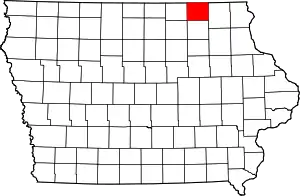
Howard County, Iowa
Howard County is a county located in the US state of Iowa. As of the 2010 census, the population was 9,566.[1] The county seat is Cresco.[2] The county was founded in 1851; it was named for General Tilghman Ashurst Howard, a Representative of Indiana.[3][4]
Howard County | |
|---|---|
 | |
 Location within the U.S. state of Iowa | |
 Iowa's location within the U.S. | |
| Coordinates: 43°21′27″N 92°18′56″W | |
| Country | |
| State | |
| Founded | 1851 |
| Named for | Tilghman Howard |
| Seat | Cresco |
| Largest city | Cresco |
| Area | |
| • Total | 474 sq mi (1,230 km2) |
| • Land | 473 sq mi (1,230 km2) |
| • Water | 0.4 sq mi (1 km2) 0.08% |
| Population (2010) | |
| • Total | 9,566 |
| • Estimate (2018) | 9,187 |
| • Density | 20/sq mi (7.8/km2) |
| Time zone | UTC−6 (Central) |
| • Summer (DST) | UTC−5 (CDT) |
| Congressional district | 1st |
| Website | www |
Geography
According to the U.S. Census Bureau, the county has a total area of 474 square miles (1,230 km2), of which 473 square miles (1,230 km2) is land and 0.4 square miles (1.0 km2) (0.08%) is water.[5]
Major highways
Adjacent counties
- Mower County, Minnesota (northwest)
- Fillmore County, Minnesota (north)
- Winnesheik County (east)
- Chickasaw County (south)
- Mitchell County (west)
- Floyd County (southwest)
Demographics
| Historical population | |||
|---|---|---|---|
| Census | Pop. | %± | |
| 1860 | 3,168 | — | |
| 1870 | 6,282 | 98.3% | |
| 1880 | 10,837 | 72.5% | |
| 1890 | 11,182 | 3.2% | |
| 1900 | 14,512 | 29.8% | |
| 1910 | 12,920 | −11.0% | |
| 1920 | 13,705 | 6.1% | |
| 1930 | 13,082 | −4.5% | |
| 1940 | 13,531 | 3.4% | |
| 1950 | 13,105 | −3.1% | |
| 1960 | 12,734 | −2.8% | |
| 1970 | 11,442 | −10.1% | |
| 1980 | 11,114 | −2.9% | |
| 1990 | 9,809 | −11.7% | |
| 2000 | 9,932 | 1.3% | |
| 2010 | 9,566 | −3.7% | |
| 2018 (est.) | 9,187 | [6] | −4.0% |
| U.S. Decennial Census[7] 1790-1960[8] 1900-1990[9] 1990-2000[10] 2010-2018[1] | |||
2010 census
The 2010 census recorded a population of 9,566 in the county, with a population density of 20.207/sq mi (7.8020/km2). There were 4,367 housing units, of which 3,944 were occupied.[11]
2000 census
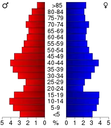
At the 2000 census,[12] there were 9,932 people, 3,974 households and 2,650 families residing in the county. The population density was 21 per square mile (8/km2). There were 4,327 housing units at an average density of 9 per square mile (4/km2). The racial makeup of the county was 99.06% White, 0.11% Black or African American, 0.15% Native American, 0.17% Asian, 0.08% from other races, and 0.42% from two or more races. 0.55% of the population were Hispanic or Latino of any race.
There were 3,974 households, of which 31.1% had children under the age of 18 living with them, 56.8% were married couples living together, 6.6% had a female householder with no husband present, and 33.3% were non-families. 29.5% of all households were made up of individuals, and 15.6% had someone living alone who was 65 years of age or older. The average household size was 2.43 and the average family size was 3.03.
26.30% of the population were under the age of 18, 6.8% from 18 to 24, 25.4% from 25 to 44, 21.3% from 45 to 64, and 20.1% who were 65 years of age or older. The median age was 40 years. For every 100 females there were 97.0 males. For every 100 females age 18 and over, there were 96.3 males.
The median household income was $34,641 and the median family income was $43,284. Males had a median income of $28,856 compared $21,367 for females. The per capita income for the county was $17,842. About 5.6% of families and 9.3% of the population were below the poverty line, including 8.7% of those under age 18 and 8.8% of those age 65 or over.
Events
The Mighty Howard County Fair is held annually in Cresco, in the last full week of June. This celebration originated in 1858, and three fairs were celebrated before being interrupted by the American Civil War. They resumed from 1866 through 1899, and were resumed in 1923 under aegis of the present directorship.[13]
Communities
Unincorporated communities
- Bonaire
- Florenceville
- Schley
Townships
Population ranking
The population ranking of the following table is based on the 2010 census of Howard County.[14]
† county seat
| Rank | City/Town/etc. | Municipal type | Population (2010 Census) |
|---|---|---|---|
| 1 | † Cresco | City | 3,868 |
| 2 | Riceville (partially in Mitchell County) | City | 785 |
| 3 | Elma | City | 546 |
| 4 | Lime Springs | City | 505 |
| 5 | Protivin (partially in Chickasaw County) | City | 283 |
| 6 | Chester | City | 127 |
Notable people
- Norman Borlaug (1914–2009) - Nobel Peace Prize winner who was raised and went to school in the county.
Politics
Howard County is the only county in the nation to vote for Obama by more than 20 points in 2012 and then Trump by more than 20 points in 2016. Because of this, it is sometimes incorrectly noted as the county with the biggest swing from Democrat to Republican between 2012 and 2016, swinging by 41 percentage points. However, there were other counties with higher swings, such as Elliott County, Kentucky, which swung 23.6% towards the Republicans (A percentage change of 46.3).
| Year | Republican | Democratic | Third Parties |
|---|---|---|---|
| 2020 | 63.1% 3,127 | 35.8% 1,772 | 1.1% 53 |
| 2016 | 57.3% 2,611 | 36.8% 1,677 | 5.9% 271 |
| 2012 | 38.6% 1,795 | 59.6% 2,768 | 1.8% 82 |
| 2008 | 36.4% 1,722 | 62.2% 2,941 | 1.4% 66 |
| 2004 | 43.2% 2,028 | 55.7% 2,614 | 1.2% 55 |
| 2000 | 42.8% 1,922 | 54.0% 2,426 | 3.2% 143 |
| 1996 | 34.7% 1,528 | 52.3% 2,303 | 13.0% 574 |
| 1992 | 31.2% 1,516 | 43.2% 2,099 | 25.7% 1,247 |
| 1988 | 45.6% 1,970 | 53.9% 2,330 | 0.6% 25 |
| 1984 | 55.5% 2,718 | 43.6% 2,135 | 0.9% 45 |
| 1980 | 53.4% 2,975 | 39.7% 2,214 | 6.9% 387 |
| 1976 | 46.6% 2,618 | 51.9% 2,917 | 1.4% 81 |
| 1972 | 54.4% 2,980 | 44.5% 2,439 | 1.1% 62 |
| 1968 | 53.9% 3,141 | 41.5% 2,420 | 4.6% 266 |
| 1964 | 38.0% 2,360 | 61.8% 3,841 | 0.2% 10 |
| 1960 | 49.8% 3,378 | 50.2% 3,406 | 0.0% 0 |
| 1956 | 52.9% 3,491 | 47.0% 3,106 | 0.1% 8 |
| 1952 | 62.6% 4,305 | 37.3% 2,564 | 0.2% 12 |
| 1948 | 43.2% 2,630 | 55.5% 3,378 | 1.4% 82 |
| 1944 | 48.4% 2,961 | 51.2% 3,132 | 0.3% 21 |
| 1940 | 50.2% 3,714 | 49.6% 3,675 | 0.2% 16 |
| 1936 | 41.5% 2,947 | 54.4% 3,861 | 4.1% 290 |
| 1932 | 36.4% 2,426 | 62.7% 4,176 | 0.8% 56 |
| 1928 | 51.2% 3,375 | 48.4% 3,193 | 0.4% 26 |
| 1924 | 47.7% 2,850 | 26.8% 1,604 | 25.5% 1,525 |
| 1920 | 66.5% 3,601 | 31.7% 1,717 | 1.9% 100 |
| 1916 | 48.9% 1,562 | 48.8% 1,560 | 2.3% 75 |
| 1912 | 23.9% 750 | 45.2% 1,416 | 30.9% 969 |
| 1908 | 50.1% 1,530 | 46.1% 1,408 | 3.8% 116 |
| 1904 | 59.9% 1,823 | 36.0% 1,096 | 4.0% 123 |
| 1900 | 56.3% 1,944 | 41.1% 1,420 | 2.6% 89 |
| 1896 | 55.2% 1,929 | 43.2% 1,507 | 1.6% 56 |
References
- "State & County QuickFacts". United States Census Bureau. Archived from the original on June 7, 2011. Retrieved July 17, 2014.
- "Find a County". National Association of Counties. Archived from the original on May 31, 2011. Retrieved June 7, 2011.
- "Howard County, Iowa - History". Howard County, Iowa. Retrieved March 6, 2014.
- Gannett, Henry (1905). The Origin of Certain Place Names in the United States. Govt. Print. Off. p. 162.
- "US Gazetteer files: 2010, 2000, and 1990". United States Census Bureau. February 12, 2011. Retrieved April 23, 2011.
- "Population and Housing Unit Estimates". Retrieved June 24, 2019.
- "U.S. Decennial Census". United States Census Bureau. Retrieved July 17, 2014.
- "Historical Census Browser". University of Virginia Library. Retrieved July 17, 2014.
- "Population of Counties by Decennial Census: 1900 to 1990". United States Census Bureau. Retrieved July 17, 2014.
- "Census 2000 PHC-T-4. Ranking Tables for Counties: 1990 and 2000" (PDF). United States Census Bureau. Retrieved July 17, 2014.
- "Population & Housing Occupancy Status 2010". United States Census Bureau – American FactFinder. Retrieved May 17, 2011.
- "U.S. Census website". United States Census Bureau. Retrieved January 31, 2008.
- About the Society
- "2010 U.S. Census website". United States Census Bureau. Retrieved September 17, 2016.
- Leip, David. "Dave Leip's Atlas of U.S. Presidential Elections". uselectionatlas.org. Retrieved April 26, 2018.
- "2020 Iowa President Election Results". desmoinesregister.com. Retrieved February 3, 2021.
External links
| Wikimedia Commons has media related to Howard County, Iowa. |
Places adjacent to Howard County, Iowa | |
|---|---|
Municipalities and communities of Howard County, Iowa, United States | ||
|---|---|---|
| Cities | Map of Iowa highlighting Howard County | |
| Unincorporated community | ||
| Footnotes | ‡This populated place also has portions in an adjacent county or counties | |
| ||

| Authority control |
|---|