Washington County, Iowa
Washington County is a county located in the U.S. state of Iowa. As of the 2010 census, the population was 21,704.[1] The county seat is Washington.[2]
Washington County | |
|---|---|
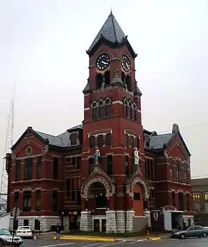 Washington County Courthouse | |
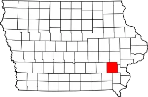 Location within the U.S. state of Iowa | |
 Iowa's location within the U.S. | |
| Coordinates: 41°20′05″N 91°43′11″W | |
| Country | |
| State | |
| Founded | January 18, 1838 |
| Named for | George Washington |
| Seat | Washington |
| Largest city | Washington |
| Area | |
| • Total | 571 sq mi (1,480 km2) |
| • Land | 569 sq mi (1,470 km2) |
| • Water | 2.1 sq mi (5 km2) 0.4% |
| Population (2010) | |
| • Total | 21,704 |
| • Estimate (2018) | 22,141 |
| • Density | 38/sq mi (15/km2) |
| Time zone | UTC−6 (Central) |
| • Summer (DST) | UTC−5 (CDT) |
| Congressional district | 2nd |
Washington County is included in the Iowa City Metropolitan Statistical Area.[3]
History
Washington County was originally formed in 1838 as Slaughter County in honor of William B. Slaughter, the secretary of Wisconsin Territory.[4] The county, still named Slaughter County, became part of Iowa Territory on July 4, 1838 when it was organized. To honor George Washington, the county opted to change its name on January 25, 1839.[5][6] The first settlers arrived in Washington County in 1835. The homesteads did not start until 1836. A town, Astoria, was built in the present township of Oregon; it became the first county seat and housed the first court house. The county seat was moved to the city of Washington in 1839.[7]
The first religious society, organized by Reverend J.L. Kirkpatrick, a Methodist minister was created in 1839.[7] The first newspaper was established in 1853; it was published for two years. In 1856 another newspaper started up; it has continued to the present.[8] The major waterways through Washington County are the Skunk and English Rivers, and Crooked Creek. Timber is found in abundance around these waterways, which has allowed a timber industry to grow up.[7] In 1855 Washington hosted the county's first bank. The county population swelled after 1858, when a railway line belonging to the Mississippi and Missouri Railroad was laid there.[8]
Geography
According to the U.S. Census Bureau, the county has a total area of 571 square miles (1,480 km2), of which 569 square miles (1,470 km2) is land and 2.1 square miles (5.4 km2) (0.4%) is water.[9]
Major highways
.svg.png.webp) U.S. Highway 218
U.S. Highway 218 Iowa Highway 1
 Iowa Highway 22
 Iowa Highway 27
 Iowa Highway 78
 Iowa Highway 92
Adjacent counties
- Iowa County (northwest)
- Johnson County (northeast)
- Louisa County (east)
- Henry County (southeast)
- Jefferson County (southwest)
- Keokuk County (west)
Demographics
| Historical population | |||
|---|---|---|---|
| Census | Pop. | %± | |
| 1850 | 4,957 | — | |
| 1860 | 14,235 | 187.2% | |
| 1870 | 18,952 | 33.1% | |
| 1880 | 20,374 | 7.5% | |
| 1890 | 18,468 | −9.4% | |
| 1900 | 20,718 | 12.2% | |
| 1910 | 19,925 | −3.8% | |
| 1920 | 20,421 | 2.5% | |
| 1930 | 19,822 | −2.9% | |
| 1940 | 20,055 | 1.2% | |
| 1950 | 19,557 | −2.5% | |
| 1960 | 19,406 | −0.8% | |
| 1970 | 18,967 | −2.3% | |
| 1980 | 20,141 | 6.2% | |
| 1990 | 19,612 | −2.6% | |
| 2000 | 20,670 | 5.4% | |
| 2010 | 21,704 | 5.0% | |
| 2018 (est.) | 22,141 | [10] | 2.0% |
| U.S. Decennial Census[11] 1790-1960[12] 1900-1990[13] 1990-2000[14] 2010-2018[1] | |||
2010 census
The 2010 census recorded a population of 21,704 in the county, with a population density of 38.1636/sq mi (14.7350/km2). There were 9,516 housing units, of which 8,741 were occupied.[15]
2000 census
As of the census[16] of 2000, there were 20,670 people, 8,056 households, and 5,631 families residing in the county. The population density was 36 inhabitants per square mile (14/km2). There were 8,543 housing units at an average density of 15 per square mile (5.8/km2). The racial makeup of the county was 97.04% White, 0.29% Black or African American, 0.19% Native American, 0.25% Asian, 0.03% Pacific Islander, 1.51% from other races, and 0.68% from two or more races. 2.73% of the population were Hispanic or Latino of any race.
There were 8,056 households, out of which 31.40% had children under the age of 18 living with them, 60.30% were married couples living together, 6.70% had a female householder with no husband present, and 30.10% were non-families. 26.40% of all households were made up of individuals, and 12.50% had someone living alone who was 65 years of age or older. The average household size was 2.50 and the average family size was 3.04.
In the county, the population was spread out, with 26.10% under the age of 18, 7.00% from 18 to 24, 26.80% from 25 to 44, 22.30% from 45 to 64, and 17.90% who were 65 years of age or older. The median age was 39 years. For every 100 females, there were 93.00 males. For every 100 females age 18 and over, there were 90.10 males.
The median income for a household in the county was $39,103, and the median income for a family was $45,636. Males had a median income of $29,592 versus $22,818 for females. The per capita income for the county was $18,221. About 5.10% of families and 7.60% of the population were below the poverty line, including 10.30% of those under age 18 and 7.30% of those age 65 or over.
Education
The county is served by 3 school districts[17]
- Highland Community School District
- Mid-Prairie Community School District
- Washington Community School District.
Highland Community School District includes:[18]
- Highland Elementary School
- Highland Middle School
- Highland High School
Communities
Townships
Population ranking
The population ranking of the following table is based on the 2010 census of Washington County.[19]
† county seat
| Rank | City/Town/etc. | Municipal type | Population (2010 Census) |
|---|---|---|---|
| 1 | † Washington | City | 7,266 |
| 2 | Kalona | City | 2,363 |
| 3 | Wellman | City | 1,408 |
| 4 | Riverside | City | 993 |
| 5 | Brighton | City | 652 |
| 6 | Ainsworth | City | 567 |
| 7 | Crawfordsville | City | 264 |
| 8 | West Chester | City | 146 |
| 9 | Coppock (partially in Henry and Jefferson Counties) | City | 47 |
Politics
| Year | Republican | Democratic | Third Parties |
|---|---|---|---|
| 2016 | 56.5% 6,173 | 36.1% 3,943 | 7.4% 813 |
| 2012 | 50.6% 5,562 | 46.5% 5,115 | 3.0% 327 |
| 2008 | 49.4% 5,247 | 48.6% 5,170 | 2.0% 212 |
| 2004 | 55.9% 5,977 | 43.0% 4,595 | 1.1% 116 |
| 2000 | 53.1% 4,827 | 43.2% 3,932 | 3.7% 335 |
| 1996 | 44.1% 3,600 | 46.8% 3,828 | 9.1% 745 |
| 1992 | 39.7% 3,576 | 37.5% 3,384 | 22.8% 2,058 |
| 1988 | 49.1% 3,741 | 49.6% 3,776 | 1.3% 99 |
| 1984 | 59.4% 4,613 | 39.6% 3,079 | 1.0% 78 |
| 1980 | 52.0% 3,967 | 37.7% 2,877 | 10.3% 783 |
| 1976 | 54.0% 4,218 | 44.2% 3,448 | 1.8% 141 |
| 1972 | 64.1% 5,187 | 34.4% 2,784 | 1.5% 118 |
| 1968 | 61.7% 4,899 | 33.7% 2,679 | 4.6% 365 |
| 1964 | 41.9% 3,315 | 57.9% 4,587 | 0.2% 17 |
| 1960 | 64.5% 5,861 | 35.5% 3,222 | 0.1% 6 |
| 1956 | 65.8% 5,844 | 34.1% 3,022 | 0.1% 10 |
| 1952 | 72.5% 6,946 | 27.2% 2,604 | 0.4% 35 |
| 1948 | 56.8% 4,680 | 42.3% 3,485 | 1.0% 80 |
| 1944 | 60.6% 5,308 | 39.1% 3,423 | 0.4% 32 |
| 1940 | 58.1% 5,649 | 41.5% 4,030 | 0.4% 42 |
| 1936 | 50.7% 4,619 | 48.0% 4,379 | 1.3% 120 |
| 1932 | 45.3% 3,889 | 53.0% 4,554 | 1.8% 152 |
| 1928 | 68.0% 5,948 | 31.5% 2,754 | 0.5% 40 |
| 1924 | 60.3% 5,053 | 22.3% 1,868 | 17.4% 1,457 |
| 1920 | 71.1% 5,813 | 27.6% 2,257 | 1.3% 107 |
| 1916 | 55.3% 2,745 | 43.1% 2,139 | 1.6% 79 |
| 1912 | 26.4% 1,264 | 41.8% 2,003 | 31.9% 1,530 |
| 1908 | 53.8% 2,631 | 43.3% 2,119 | 2.8% 139 |
| 1904 | 59.2% 2,875 | 36.5% 1,772 | 4.2% 206 |
| 1900 | 54.3% 2,844 | 42.6% 2,234 | 3.1% 163 |
| 1896 | 54.4% 2,882 | 43.3% 2,292 | 2.3% 122 |
See also
- Washington County Courthouse
- National Register of Historic Places listings in Washington County, Iowa
- Bontrager Family Singers
References
- "State & County QuickFacts". United States Census Bureau. Retrieved July 20, 2014.
- "Find a County". National Association of Counties. Retrieved June 7, 2011.
- United States Office of Management and Budget. "Update of Statistical Area Definitions and Guidance on Their Uses" (PDF). pp. 5, 36. Archived from the original (PDF) on May 14, 2006. Retrieved July 21, 2006.
- http://files.usgwarchives.org/ia/defunct/history/1903slau.txt
- "Washington County, Iowa Genealogy Genealogy - FamilySearch Wiki". familysearch.org. Retrieved September 28, 2016.
- Washington County – History
- "Washington County, Iowa". Past 2 Present. Archived from the original on March 6, 2012. Retrieved December 15, 2017.
- An illustrated history of the state of Iowa, being a complete civil, political, and military history of the state, from its first exploration down to 1875. Archive.org. Retrieved September 5, 2013.
- "US Gazetteer files: 2010, 2000, and 1990". United States Census Bureau. February 12, 2011. Retrieved April 23, 2011.
- "Population and Housing Unit Estimates". Retrieved June 20, 2019.
- "U.S. Decennial Census". United States Census Bureau. Retrieved July 20, 2014.
- "Historical Census Browser". University of Virginia Library. Retrieved July 20, 2014.
- "Population of Counties by Decennial Census: 1900 to 1990". United States Census Bureau. Retrieved July 20, 2014.
- "Census 2000 PHC-T-4. Ranking Tables for Counties: 1990 and 2000" (PDF). United States Census Bureau. Retrieved July 20, 2014.
- "Population & Housing Occupancy Status 2010". United States Census Bureau – American FactFinder. Retrieved June 18, 2011.
- "U.S. Census website". United States Census Bureau. Retrieved January 31, 2008.
- Education, Iowa Department of (September 2008). "Web Report Engine - Address". Retrieved May 29, 2009.
- "Highland Community School District". Highland Community School District. Retrieved May 30, 2018.
- 2010 Census
- Leip, David. "Dave Leip's Atlas of U.S. Presidential Elections". uselectionatlas.org. Retrieved April 28, 2018.
External links
| Wikimedia Commons has media related to Washington County, Iowa. |
Places adjacent to Washington County, Iowa | ||||||||||
|---|---|---|---|---|---|---|---|---|---|---|
| ||||||||||
Municipalities and communities of Washington County, Iowa, United States | ||
|---|---|---|
| Cities | Map of Iowa highlighting Washington County | |
| Townships | ||
| Unincorporated communities | ||
| Footnotes | ‡This populated place also has portions in an adjacent county or counties | |
| ||

| Authority control |
|---|