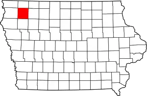
O'Brien County, Iowa
O'Brien County is a county in the U.S. state of Iowa. As of the 2010 United States Census, the population was 14,398.[2] The county seat is Primghar.[3]
O'Brien County | |
|---|---|
 | |
 Location within the U.S. state of Iowa | |
 Iowa's location within the U.S. | |
| Coordinates: 43°04′53″N 95°37′34″W | |
| Country | |
| State | |
| Founded | 15 January 1851[1] |
| Named for | William Smith O'Brien |
| Seat | Primghar |
| Largest city | Sheldon |
| Area | |
| • Total | 573 sq mi (1,480 km2) |
| • Land | 573 sq mi (1,480 km2) |
| • Water | 0.2 sq mi (0.5 km2) 0.03% |
| Population (2010) | |
| • Total | 14,398 |
| • Estimate (2018) | 13,840 |
| • Density | 25/sq mi (9.7/km2) |
| Time zone | UTC−6 (Central) |
| • Summer (DST) | UTC−5 (CDT) |
| Congressional district | 4th |
| Website | www |
History
By the time Iowa attained statehood (28 December 1848), its Territorial Legislature had created 44 counties. On 15 January 1851 the new State Legislature created another 49 counties, defining them by lines of survey. O'Brien was among the 49 units thus created.[1] It consists of four survey townships, each formed by 36 square miles arranged in a 6x6 layout, for a nominal 576 square miles total area. The county was named for William Smith O'Brien, a leader for Irish independence in 1848.[4]
The new county's first settler arrived in 1856; Hannibal H. Waterman brought his wife and a daughter to the southeast portion (present Waterman Township). His homestead formed the nucleus of the county's first community, and a small building was erected there to function as a courthouse.
By 1872 the county comprised several small communities, and residents of those groups felt the county's business should be conducted in a more central location. An election was held, the outcome of which was to create a new county seat at its midpoint. A 40-acre (16.2 hectare) tract at the center of the county was surveyed and platted; its name (Primghar) was created from the initials of eight persons involved with the platting. The previous courthouse building was transported to this new location.[5]
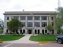
In 1874 a 35-foot square building was erected on the present location at a cost of $2,000, to replace the first structure. It was replaced in 1887 by a larger structure. The County Board of Supervisors authorized its construction, at a cost not to exceed $5,000 (the maximum amount the County was authorized to commit). To keep within this limit, members of the new community agreed to haul the building materials without charge from railroad stops at Sanbor and Paullina. The present courthouse was completed in 1917,[6] and is listed on the National Register of Historic Places.
Geography
According to the United States Census Bureau, the county has a total area of 573 square miles (1,480 km2), of which 573 square miles (1,480 km2) is land and 0.2 square miles (0.52 km2) (0.03%) is water.[7]
Major highways
Adjacent counties
- Osceola County - north
- Clay County - east
- Cherokee County - south
- Sioux County - west
Demographics
| Historical population | |||
|---|---|---|---|
| Census | Pop. | %± | |
| 1860 | 383 | — | |
| 1870 | 715 | 86.7% | |
| 1880 | 4,155 | 481.1% | |
| 1890 | 13,060 | 214.3% | |
| 1900 | 16,985 | 30.1% | |
| 1910 | 17,262 | 1.6% | |
| 1920 | 19,051 | 10.4% | |
| 1930 | 18,409 | −3.4% | |
| 1940 | 19,293 | 4.8% | |
| 1950 | 18,970 | −1.7% | |
| 1960 | 18,840 | −0.7% | |
| 1970 | 17,522 | −7.0% | |
| 1980 | 16,972 | −3.1% | |
| 1990 | 15,444 | −9.0% | |
| 2000 | 15,102 | −2.2% | |
| 2010 | 14,398 | −4.7% | |
| 2018 (est.) | 13,840 | [8] | −3.9% |
| US Decennial Census[9] 1790-1960[10] 1900-1990[11] 1990-2000[12] 2010-2018[2] | |||
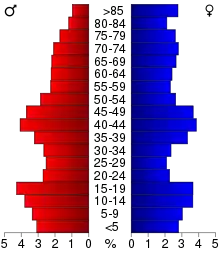
As of the 2010 United States Census,[13] there were 14,398 people, 6,069 households, and 3,927 families in the county. The population density was 25.1239/sq mi (9.7004/km2). There were 6,649 housing units at an average density of 11 per square mile (4/km2). The racial makeup of the county was 96.0% White, 0.5% Black or African American, 0.1% American Indian, 0.6% Asian, 2.0% from other races, and 0.8% from two or more races. The county has a 3.8% Hispanic or Latino background.
There were 6,069 households, out of which 26.0% had children under the age of 18 living with them, 55.1% were married couples living together, 6.1% had a female householder with no husband present, 3.5% had a male householder with no wife present, and 35.3% were non-families. 31.5% of all households were made up of individuals living alone, and 33.1% had someone living alone who was 65 years of age or older. The average household size was 2.31 and the average family size was 2.89.
The county population contained 25.7% under the age of 20, 4.6% from 20 to 24, 21.3% from 25 to 44, 28.1% from 45 to 64, and 20.4% who were 65 years of age or older. The median age was 43.6 years. For every 100 females there were 95.80 males. For every 100 females, there were 99.1 males.
The median income for a household in the county was $44,018, and the median income for a family was $58,127. The per capita income for the county was $24,771. About 6.3% of families and 11.0% of the population were below the poverty line, including 15.7% of those under age 18 and 8.3% of those age 65 or over.[14]
Communities
Unincorporated communities
Townships
Population ranking
The population ranking of the following table is based on the 2010 census of O'Brien County.[15]
† county seat
| Rank | City/Town/etc. | Municipal type | Population (2010 Census) |
|---|---|---|---|
| 1 | Sheldon (partially in Sioux County) | City | 5,017 (5,188 total) |
| 2 | Hartley | City | 1,672 |
| 3 | Sanborn | City | 1,404 |
| 4 | Paullina | City | 1,056 |
| 5 | † Primghar | City | 909 |
| 6 | Sutherland | City | 649 |
| 7 | Calumet | City | 170 |
| 8 | Archer | City | 131 |
Politics
| Year | Republican | Democratic | Third Parties |
|---|---|---|---|
| 2016 | 77.7% 5,752 | 17.8% 1,315 | 4.6% 339 |
| 2012 | 71.7% 5,266 | 26.8% 1,969 | 1.4% 106 |
| 2008 | 66.7% 4,894 | 31.9% 2,338 | 1.4% 101 |
| 2004 | 68.9% 5,328 | 30.1% 2,330 | 0.9% 73 |
| 2000 | 66.4% 4,674 | 30.8% 2,170 | 2.8% 200 |
| 1996 | 57.6% 3,877 | 33.2% 2,236 | 9.2% 622 |
| 1992 | 51.1% 3,869 | 28.0% 2,122 | 21.0% 1,587 |
| 1988 | 60.0% 4,241 | 39.1% 2,768 | 0.9% 63 |
| 1984 | 66.2% 5,008 | 32.8% 2,479 | 1.1% 82 |
| 1980 | 63.6% 4,937 | 28.5% 2,210 | 7.9% 614 |
| 1976 | 61.9% 4,643 | 36.4% 2,732 | 1.8% 131 |
| 1972 | 68.9% 5,159 | 29.7% 2,224 | 1.4% 108 |
| 1968 | 69.3% 5,594 | 26.6% 2,146 | 4.1% 328 |
| 1964 | 50.2% 4,336 | 49.7% 4,295 | 0.1% 6 |
| 1960 | 68.7% 6,509 | 31.3% 2,967 | 0.0% 4 |
| 1956 | 67.3% 6,138 | 32.6% 2,970 | 0.1% 10 |
| 1952 | 76.2% 7,130 | 23.4% 2,192 | 0.4% 38 |
| 1948 | 50.5% 3,697 | 46.7% 3,421 | 2.8% 208 |
| 1944 | 56.0% 4,033 | 43.6% 3,138 | 0.4% 30 |
| 1940 | 53.3% 4,760 | 46.3% 4,133 | 0.4% 38 |
| 1936 | 38.9% 3,350 | 59.7% 5,139 | 1.4% 123 |
| 1932 | 40.9% 3,213 | 57.4% 4,503 | 1.7% 132 |
| 1928 | 66.4% 4,845 | 32.8% 2,397 | 0.8% 56 |
| 1924 | 58.5% 4,172 | 10.6% 756 | 30.9% 2,207 |
| 1920 | 76.5% 5,137 | 21.9% 1,468 | 1.6% 109 |
| 1916 | 52.5% 2,021 | 46.5% 1,787 | 1.0% 39 |
| 1912 | 16.0% 620 | 38.9% 1,506 | 45.1% 1,744 |
| 1908 | 57.7% 1,912 | 40.0% 1,326 | 2.3% 76 |
| 1904 | 68.9% 2,279 | 26.8% 885 | 4.3% 142 |
| 1900 | 61.2% 2,386 | 37.5% 1,461 | 1.4% 54 |
| 1896 | 60.1% 2,421 | 38.8% 1,562 | 1.1% 45 |
See also
References
- Columbia-Lippincott Gazetteer, (New York:Columbia University Press, 1952), p. 1363
- "State & County QuickFacts". US Census Bureau. Archived from the original on June 7, 2011. Retrieved July 20, 2014.
- "Find a County". National Association of Counties. Retrieved June 7, 2011.
- Chicago and North Western Railway Company (1908). A History of the Origin of the Place Names Connected with the Chicago & North Western and Chicago, St. Paul, Minneapolis & Omaha Railways. p. 162.
- About O'Brien County (O'Brien County website; accessed 1 June 2020)
- "O'Brien County Courthouse". Iowa Judicial Branch. Archived from the original on 1 April 2012. Retrieved 7 March 2011.
- "US Gazetteer files". US Census Bureau. 12 February 2011. Retrieved 23 April 2011.
- "Population and Housing Unit Estimates". Retrieved 27 June 2019.
- "US Decennial Census". US Census Bureau. Retrieved July 20, 2014.
- "Historical Census Browser". University of Virginia Library. Retrieved July 20, 2014.
- "Population of Counties by Decennial Census: 1900 to 1990". US Census Bureau. Retrieved July 20, 2014.
- "Census 2000 PHC-T-4. Ranking Tables for Counties: 1990 and 2000" (PDF). US Census Bureau. Retrieved July 20, 2014.
- "US Census website". US Census Bureau. Retrieved January 31, 2008.
- "Population and Housing Occupancy Status: 2010 - State -- County". US Census Bureau/American FactFinder. Retrieved March 26, 2011.
- 2010 Census
- Leip, David. "Atlas of US Presidential Elections". uselectionatlas.org. Retrieved April 27, 2018.
External links
| Wikimedia Commons has media related to O'Brien County, Iowa. |
- O'Brien County Portal style website, Government, Business, Tourism and more
- IaGenWeb O'Brien county history, Biographies, and more
- City-Data Comprehensive Statistical Data and more about O'Brien County
Places adjacent to O'Brien County, Iowa | ||||||||||
|---|---|---|---|---|---|---|---|---|---|---|
| ||||||||||
Municipalities and communities of O'Brien County, Iowa, United States | ||
|---|---|---|
| Cities | Map of Iowa highlighting O'Brien County | |
| Townships | ||
| Other unincorporated communities | ||
| Footnotes | ‡This populated place also has portions in an adjacent county or counties | |
| ||

| Authority control |
|---|