Apremont, Ain
Apremont is a commune in the department of Ain in the Auvergne-Rhône-Alpes region of eastern France.
Apremont | |
|---|---|
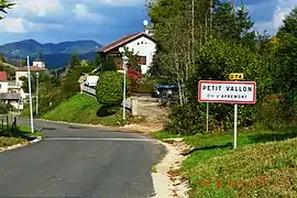 The road into Petit Vallon in Apremont | |
Location of Apremont 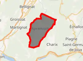
| |
 Apremont  Apremont | |
| Coordinates: 46°12′28″N 5°39′26″E | |
| Country | France |
| Region | Auvergne-Rhône-Alpes |
| Department | Ain |
| Arrondissement | Nantua |
| Canton | Nantua |
| Intercommunality | Haut-Bugey Agglomération |
| Government | |
| • Mayor (2020–2026) | Claude Doche |
| Area 1 | 14.57 km2 (5.63 sq mi) |
| Population (2017-01-01)[1] | 376 |
| • Density | 26/km2 (67/sq mi) |
| Time zone | UTC+01:00 (CET) |
| • Summer (DST) | UTC+02:00 (CEST) |
| INSEE/Postal code | 01011 /01100 |
| Elevation | 658–1,042 m (2,159–3,419 ft) (avg. 850 m or 2,790 ft) |
| 1 French Land Register data, which excludes lakes, ponds, glaciers > 1 km2 (0.386 sq mi or 247 acres) and river estuaries. | |
The inhabitants of the commune are known as Marranes[2]
Geography
Apremont is located halfway between Nantua and Oyonnax some 20 km north-west of Bellegarde-sur-Valserine and 40 km east of Bourg-en-Bresse. The commune has an area of 1456 hectares and is bounded by the communes of Bellignat, Oyonnax, Charix, Nantua, Montreal-la-Cluse, Martignat, and Groissiat. The commune is composed of several villages including:
- Petit Vallon
- Grand Vallon
- La Gotette
- Ablatrix
There are also a few isolated farms such as Les Éterres, le Cree, and Molet.
The commune can be accessed by road D74 from Oyonnax in the north passing through the heart of the commune and the village and continuing to Nantua in the south. There is also access via the D95 from Charix in the south-west to the town. There are also several small roads in the commune. The commune consists of forest and mountain landscape.
The Lange river rises in the town and flows north to Oyonnax before turning south and joining the Oignin at Le Mollard.[3]
Neighbouring communes and villages[3] | ||||||||||
|---|---|---|---|---|---|---|---|---|---|---|
| ||||||||||
Administration

List of Successive Mayors of Apremont[4]
| From | To | Name | Party | Position |
|---|---|---|---|---|
| 1995 | 2001 | Jean-Pierre Girard | ||
| 2001 | 2008 | Charles Sonthonnax | ||
| 2008 | 2020 | Jean-Pierre Girard | ||
| 2020 | Present | Claude Doche |
(Not all data is known)
Population
| Year | Pop. | ±% |
|---|---|---|
| 2006 | 333 | — |
| 2007 | 333 | +0.0% |
| 2008 | 339 | +1.8% |
| 2009 | 352 | +3.8% |
| 2010 | 363 | +3.1% |
| 2011 | 374 | +3.0% |
| 2012 | 385 | +2.9% |
| 2013 | 394 | +2.3% |
| 2014 | 397 | +0.8% |
| 2015 | 390 | −1.8% |
| 2016 | 383 | −1.8% |
Sites and monuments
- Ruins of a castle built in the 13th century
See also
External links
- Apremont on Lion1906
- Apremont on Géoportail, National Geographic Institute (IGN) website (in French)
- Apremont on the 1750 Cassini Map
References
- "Populations légales 2017". INSEE. Retrieved 6 January 2020.
- Inhabitants of Ain (in French)
- Google Maps
- List of Mayors of France (in French)
| Wikimedia Commons has media related to Apremont (Ain). |
| Authority control |
|---|