Sandrans
Sandrans is a commune in the Ain department in eastern France.
Sandrans | |
|---|---|
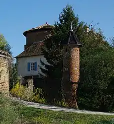 The chateau in Sandrans | |
.svg.png.webp) Coat of arms | |
Location of Sandrans 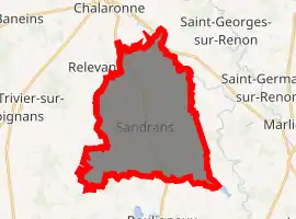
| |
 Sandrans  Sandrans | |
| Coordinates: 46°04′00″N 4°59′00″E | |
| Country | France |
| Region | Auvergne-Rhône-Alpes |
| Department | Ain |
| Arrondissement | Bourg-en-Bresse |
| Canton | Châtillon-sur-Chalaronne |
| Intercommunality | Dombes |
| Government | |
| • Mayor (2020–2026) | Bernard Taponat |
| Area 1 | 29.03 km2 (11.21 sq mi) |
| Population (2017-01-01)[1] | 530 |
| • Density | 18/km2 (47/sq mi) |
| Time zone | UTC+01:00 (CET) |
| • Summer (DST) | UTC+02:00 (CEST) |
| INSEE/Postal code | 01000 /01100 |
| Elevation | 235–291 m (771–955 ft) (avg. 280 m or 920 ft) |
| 1 French Land Register data, which excludes lakes, ponds, glaciers > 1 km2 (0.386 sq mi or 247 acres) and river estuaries. | |
Geography
The Chalaronne forms parts of the commune's northeastern border.[2]
Population
|
|
See also
References
- "Populations légales 2017". INSEE. Retrieved 6 January 2020.
- "Map of Sandrans - Michelin Sandrans map". ViaMichelin. Retrieved 17 January 2019.
| Wikimedia Commons has media related to Sandrans. |
This article is issued from Wikipedia. The text is licensed under Creative Commons - Attribution - Sharealike. Additional terms may apply for the media files.