Argis
Argis is a commune in the Ain department in the Auvergne-Rhône-Alpes region of eastern France.
Argis | |
|---|---|
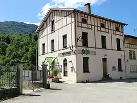 Argis Town Hall | |
.svg.png.webp) Coat of arms | |
Location of Argis 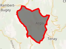
| |
 Argis  Argis | |
| Coordinates: 45°56′05″N 5°29′30″E | |
| Country | France |
| Region | Auvergne-Rhône-Alpes |
| Department | Ain |
| Arrondissement | Belley |
| Canton | Ambérieu-en-Bugey |
| Intercommunality | La Plaine de l'Ain |
| Government | |
| • Mayor (2014-2020) | Marcel Chevé |
| Area 1 | 7.84 km2 (3.03 sq mi) |
| Population (2017-01-01)[1] | 442 |
| • Density | 56/km2 (150/sq mi) |
| Time zone | UTC+01:00 (CET) |
| • Summer (DST) | UTC+02:00 (CEST) |
| INSEE/Postal code | 01017 /01230 |
| Elevation | 300–819 m (984–2,687 ft) (avg. 320 m or 1,050 ft) |
| 1 French Land Register data, which excludes lakes, ponds, glaciers > 1 km2 (0.386 sq mi or 247 acres) and river estuaries. | |
The inhabitants of the commune are known as Argissiens or Argissiennes.[2]
Geography
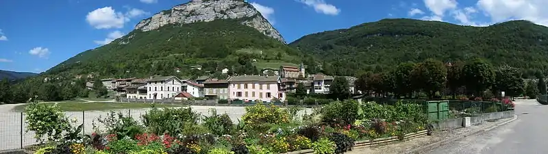
Argis is in the mountains of the southern Jura in the mountains of Bugey in the valley of the Albarine between Tenay and Saint-Rambert-en-Bugey. Altitude varies from 315 metres in the valley to 800 metres on the slopes of the valley.
The commune is some 10 km east of Amberieu-en-Bugey and 10 km south-west of Hauteville-Lompnes. It can be accessed on the D1504 road from Saint-Rambert-en-Bugey in the north-west passing through the northern border of the commune then south to the village and continuing south to Tenay. The D104 road also goes from the village over a tortuous mountain route to Arandas in the south-west. There are also many small mountain roads in the commune. The railway line from Saint-Rambert-en-Bugey to Tenay also passes through the commune parallel to the D1504 road. There is no station in the commune with the nearest station being the one near Tenay. In addition to the village there is the small hamlet of Plomb in the south. The commune is mountainous and heavily forested.[3]
The Albarine river passes through the commune from south to north parallel with the railway and the D1504 continuing west to join the Ain near Chez le Bret. A number of streams flow into the river including the Ruisseau de la Gorge, the Ruisseau de la Tine, the Biez Molet, the Biez Michel, and the Biez Gallet.[3]
Neighbouring communes and villages[3] | ||||||||||
|---|---|---|---|---|---|---|---|---|---|---|
| ||||||||||
History
There was a lordship and a castle in the Middle Ages.
Toponymy
Over the centuries, Argis has been called:[4]
- Argil (1242)
- De Argillo (1385)
- Argit (1650)
- Argy (1734)
Heraldry
Arms of Argis |
The status of the official emblem has yet to be determined.
Blazon: |
Administration
List of mayors of Argis[6]
| From | To | Name | Party | Position |
|---|---|---|---|---|
| 1944 | 1959 | Louis Dillenschneider | ||
| 1959 | 1974 | Louis Ronchall | ||
| 1974 | 1974 | Jean Reverdy | ||
| 1974 | 1999 (resigned) | André Ollier | ||
| 1999 | 2001 | Jean-Claude Marquis | ||
| 2001 | Present | Marcel Chevé |
(Not all data is known)
Population
| Year | Pop. | ±% |
|---|---|---|
| 2006 | 424 | — |
| 2007 | 421 | −0.7% |
| 2008 | 421 | +0.0% |
| 2009 | 421 | +0.0% |
| 2010 | 421 | +0.0% |
| 2011 | 421 | +0.0% |
| 2012 | 424 | +0.7% |
| 2013 | 422 | −0.5% |
| 2014 | 427 | +1.2% |
| 2015 | 433 | +1.4% |
| 2016 | 438 | +1.2% |
Sites and monuments
- Waterfalls de la Côte and de la Pissoire.
Photo gallery
 The School
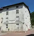 The old Post Office
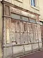 The old cobbler's shop
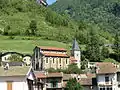 View of Argis and the church
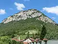 View of Argis
Notable people
- Antoine-Gaspard Boucher d'Argis was born in the commune on 3 April 1708.
See also
Notes and references
- "Populations légales 2017". INSEE. Retrieved 6 January 2020.
- Inhabitants of Ain (in French)
- Google Maps
- Regional Terms and placenames of French Switzerland and surroundings (in French).
- See in French: Argis Archived 2016-03-04 at the Wayback Machine on OLDJP - the Blazon Bank Archived 2013-07-10 at the Wayback Machine
- List of Mayors of France (in French)
External links
- Argis on Lion1906
- Argis on Géoportail, National Geographic Institute (IGN) website (in French)
- Argil on the 1750 Cassini Map
| Wikimedia Commons has media related to Argis. |