Tenay
Tenay is a commune in the Ain department in eastern France.
Tenay | |
|---|---|
_-_Pont_sur_l'Albarine.JPG.webp) The Albarine | |
.svg.png.webp) Coat of arms | |
Location of Tenay 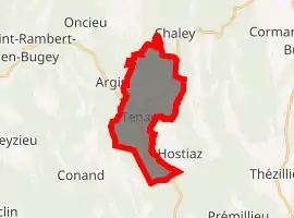
| |
 Tenay  Tenay | |
| Coordinates: 45°55′00″N 5°30′00″E | |
| Country | France |
| Region | Auvergne-Rhône-Alpes |
| Department | Ain |
| Arrondissement | Belley |
| Canton | Hauteville-Lompnes |
| Government | |
| • Mayor (2008–2014) | Perrot Marc |
| Area 1 | 13.12 km2 (5.07 sq mi) |
| Population | 1,035 |
| • Density | 79/km2 (200/sq mi) |
| Demonym(s) | Tenaysiens |
| Time zone | UTC+01:00 (CET) |
| • Summer (DST) | UTC+02:00 (CEST) |
| INSEE/Postal code | 01416 /01230 |
| Elevation | 320–1,020 m (1,050–3,350 ft) (avg. 327 m or 1,073 ft) |
| 1 French Land Register data, which excludes lakes, ponds, glaciers > 1 km2 (0.386 sq mi or 247 acres) and river estuaries. | |
Geography
The river Albarine flows southwest through the commune's eastern part, crosses the village, then flows northwest.
Population
|
|
See also
References
- "Populations légales 2017". INSEE. Retrieved 6 January 2020.
| Wikimedia Commons has media related to Tenay. |
This article is issued from Wikipedia. The text is licensed under Creative Commons - Attribution - Sharealike. Additional terms may apply for the media files.